Everything You Need to Know About Wandrer, the Newest Cycling Exploration App
There really is an app for everything these days—and the same goes for cycling and all its related aspects. You can track your rides, nutrition, and recovery; plan and explore routes; calculate gear ratios; follow training plans, and much, much more. Now, one of the latest cycling apps on the market encourages riders to get out and explore: Wandrer.
Wandrer is a cycling exploration game that encourages you to seek out and ride roads unridden, rewarding you with points when you do so, and tracking and mapping out your progress as you go. Even the pros are getting in on it, with Ronan McLaughlin including it in his top 10 recommended products for 2020 and Ted King currently ranking number 13 on the overall leaderboard.
Here, we explain how to use Wandrer, and help you get your explorer on.
What is Wandrer?
Wandrer is a web app and can be accessed via an internet browser. Craig Durkin, Wandrer’s developer, told Bicycling that he is working on a phone app version for the future, though.
“Wandrer launched in 2018 as a kind of art project called ‘All of ITP,’” Durkin explained. “Here in Atlanta, we have a highway called Interstate 285, also known as the ‘Perimeter.’ It’s an informal boundary to the city, so you’re either ITP (inside the perimeter) or OTP. This turned into an informal competition over who could complete the most roads and it seemed like folks liked it pretty well, so I renamed it Wandrer and expanded to the rest of the world a few months later.”
Wandrer currently boasts about 45,000 users, according to Durkin.
The app works in part by importing your ride data from Strava and pulling map data from OpenStreetMap. It keeps track of every road you’ve ridden and where, plus your mileage. Riding new roads will earn you one point per mile. So if you want more points, you’ll have to get out and do a little wandering.
“There are many places out there worth seeing for their own sake,” the website explains. “To find new parks, to see how your neighbors live, to eat at new restaurants, and to be some place new and unfamiliar in your own city.”
While the app is popular with cyclists, you can also get separate points for exploring on foot.
“I have many new features planned. Just this past week I added support for runs, walks, and hikes, so you can explore your neighborhood and city on foot now, too,” Durkin said. “I also have many fun routing features planned to help users create routes that maximize their new roads, rather than just direct you from point A to point B.”
How do you use Wandrer?
You can sign up for free and create an account on wandrer.earth; you’ll also need a Strava account. While creating your Wandrer account, you’ll be asked to sync it with your Strava account. You’ll be prompted to set different Strava permissions, when you want to receive notifications, and if you’d like to appear in public Wandrer leaderboards.
With a free Wandrer account, you’ll be able to import your 50 most recent Strava rides. If you’d like to import all of your rides, you can sign up for the $30 per year subscription. The subscription also includes some other perks, like a Google Chrome extension to help you plan routes and the option to download maps to your Garmin or Wahoo GPS bike computer to easily view unridden roads while on the bike.
The Dashboard
Your profile’s Dashboard is your main page in the app. You can view your ten most recent rides, your total points (click on “Details” for a breakdown of your stats!), an overview of your monthly progress, total new miles for the year, and a list of your areas ridden with shortcuts to those leaderboards.
The Big Map
Click on the “Big Map” tab at the top to see every road you’ve ridden, everywhere, highlighted for you. You can use this map to help plan routes that cover roads you’ve yet to ride, or simply relish in seeing your progress.
There’s an option to toggle between different views: map or satellite; and progress on bike, progress on foot, untraveled roads, or achievements. You can also download a map of the area—compatible with Garmin, Wahoo, and KML file programs—and report map errors.
Pick Your Challenge (If You Want)
When it comes to doing fun cycling challenges, Wandrer is great for that. It’s the perfect tool for cyclists who are aiming to ride every single road in their town or beyond. (Like this Minnesota cyclist who rode every road in his county.)
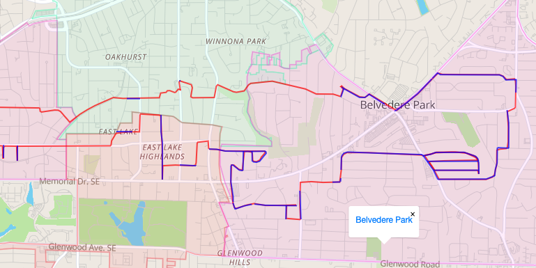
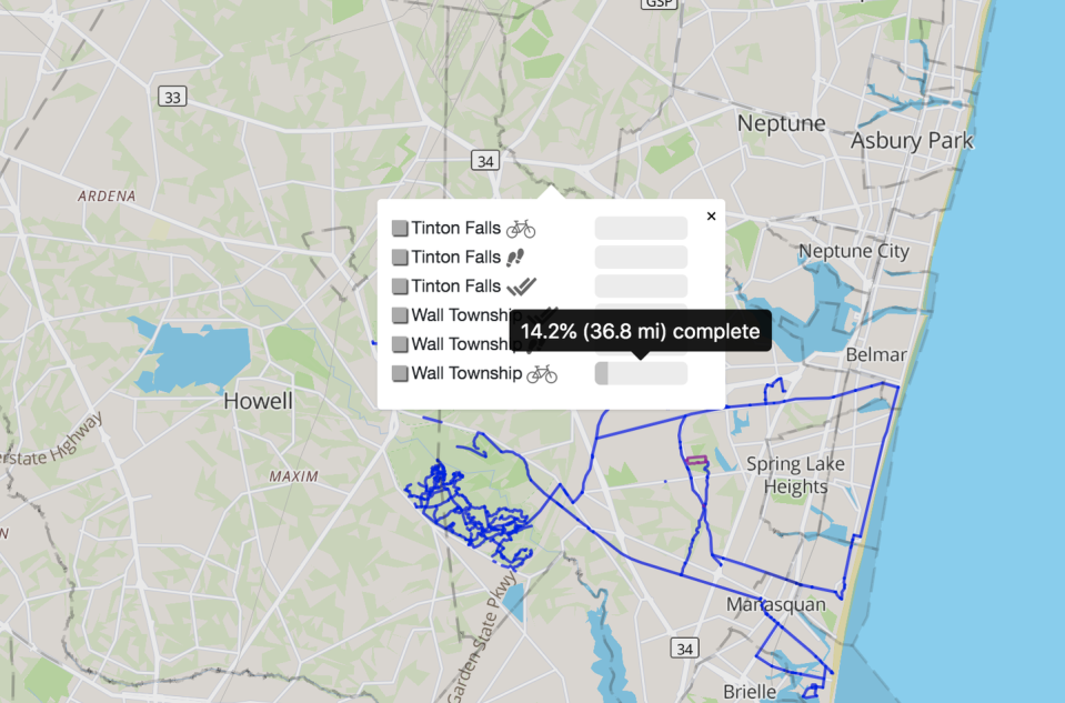
The Big Map automatically has city and township limits outlined and lets you know what percentage you’ve ridden of each: zoom in until gray-dotted lines appear, click the outline of your area of interest, then hover your mouse over the completion bars to view your stats. (See image below.)
There are also monthly challenges with major bonus points awarded to those who’ve ridden the most new miles on Earth, their continental region, their country, their state, and their county or locality—but that feature is only available to subscribers. And if you really want to aim high, there’s a leaderboard for most new miles ridden ever. Since Wandrer is an international app, you’ll have plenty of competition.
What if you have problems with Wandrer?
When you first sign up and try syncing your Strava rides, it may take some time for them to carry over. (This happened to me.) Try reloading your Dashboard or Activities page until the rides all sync and become viewable. Also make sure your Strava permissions in Wandrer are set correctly (click on “Change your Strava permissions” in Settings), and try re-authorizing Wandrer to access your Strava data. Remember, only your 50 most recent rides will sync if you have the free version of Wandrer.
You may also notice gaps in your Wandrer-mapped rides—this can sometimes be caused by imperfect GPS data. These gaps tend to be pretty minor on road rides, but may be substantial on some trail rides. I found that some trail systems could be recorded in their entirety, while others weren’t detected at all. This can be caused by poor GPS data, but it’s more likely because the trails are not yet included in OpenStreetMap data or they’re tagged by OpenStreetMap as a “footway” and considered inaccessible by bike, like in the image below. (Though I admit to doing a fair bit of hike-a-biking, so it evens out!)

“I do a fair amount of data filtering to prevent roads/paths that can’t be biked/walked from appearing in Wandrer,” Durkin explained. “So your local interstate won’t show up as valid roads, the roads on a nearby military base won’t appear as valid roads, and something like the Appalachian Trail will show up for hikers but not cyclists.”
Which is great, because you don’t want non-bikeable roads like major highways and those inaccessible to the public to throw off your percentages and stats.
“Of course, there are also shortcomings on my end too: GPS data can be noisy, and my algorithms aren’t perfect,” Durkin said. “But both of these are improving over time as well.”
You Might Also Like

