Nearly everywinter, the rest of the continental United States is surprised by headlines announcing that snow has graced the summits of Hawaii’s tallest peaks. But this week, something especially remarkable happened.
As a winter storm collided with the Aloha State over the weekend, a rare snowfall turned the much lower Polipoli Spring State Park on Maui into a wintry wonderland.
Melissa Dye, a meteorologist at the National Weather Service in Honolulu, told HuffPost that Haleakala’s summit, located 3,800 feet higher than Polipoli, saw 4-foot drifts of snow, though park rangers were unable to measure it due to strong winds.
“It’s just real light like ice now, so it’s just blowing around and drifting,” she said of the summit.
The National Weather Service doesn’t typically measure snowfall at Polipoli.
Dye also said that the temperatures at Polipoli must have been at least 32 degrees Fahrenheit, the freezing point, though the National Weather Service doesn’t have a temperature sensor there.
Snow covered Polipoli as a part of a storm that battered the islands over the weekend with strong winds, powerful surf and relatively low temperatures for the subtropical state.
As bad weather continues, the National Weather Service on Tuesday issued a winter storm watch for the summits of Haleakala on Maui and Mauna Kea and Mauna Loa on the Big Island, noting that there will be periods of “freezing rain and snow possible.”
“Very cold air aloft will once again move over the islands beginning tonight and continuing into Friday,” officials said in a notice.
Dye told HuffPost that snow in Hawaii “is not unheard of.” The peaks of Mauna Kea and Mauna Loa, which reach higher than 13,000 feet, receive snow every winter, while the summit of Haleakala volcano sees snow at elevations above 9,000 feet every three to four years.
However, snowfall at Polipoli State Park, at 6,200 feet, is out of the ordinary, Dye added.
In a Facebook post, the state’s Department of Land and Natural Resources said that this may be the first snow recorded there.
The DLNR’s State Parks office “reports that perhaps for the first time ever, snow has fallen in a Hawai‘i State Park,” officials said on Facebook. “Polipoli State Park on Maui is blanketed with snow.”
Dye said she couldn’t confirm whether it was the first time snow had ever fallen at the state park, but she did note that it was uncommon.
For local residents, the white-dusted mountain was a sight to behold.
The National Weather Service in Honolulu described the storm battering Hawaii over the weekend as a “historic low pressure system” in a tweet on Sunday.
Winds of up to 191 miles per hour whipped at Mauna Kea’s peak on Sunday, while a maelstrom of waves up to 60 feet churned on Oahu’s north shore.
This story was updated with a clarification from Dye that the 4-foot drifts occurred at Haleakala’s summit.
Also on HuffPost
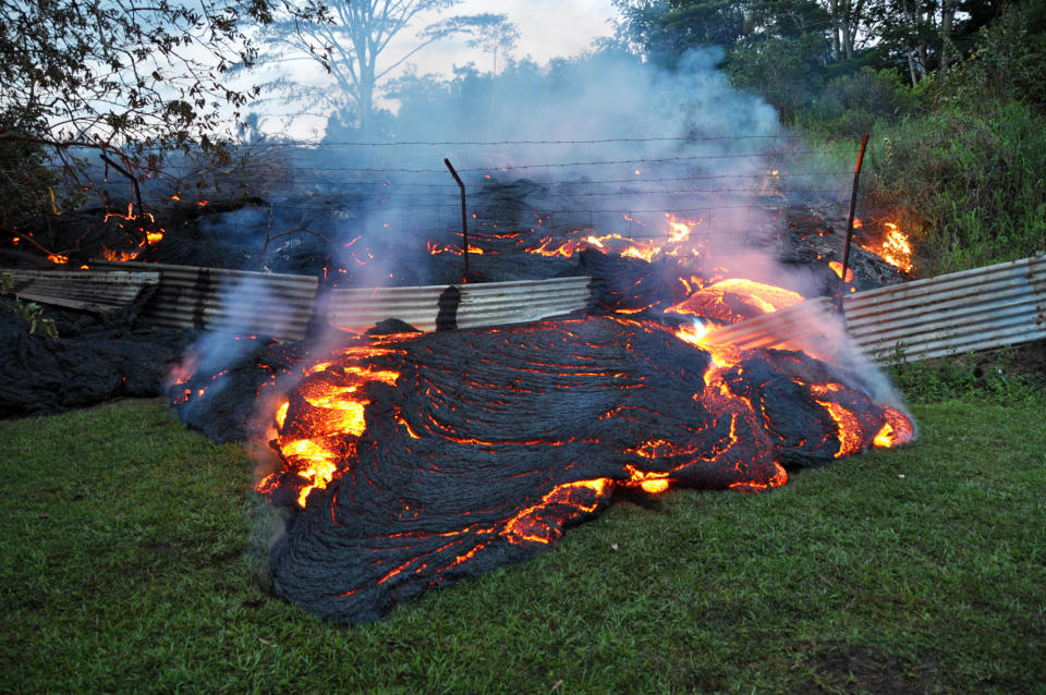
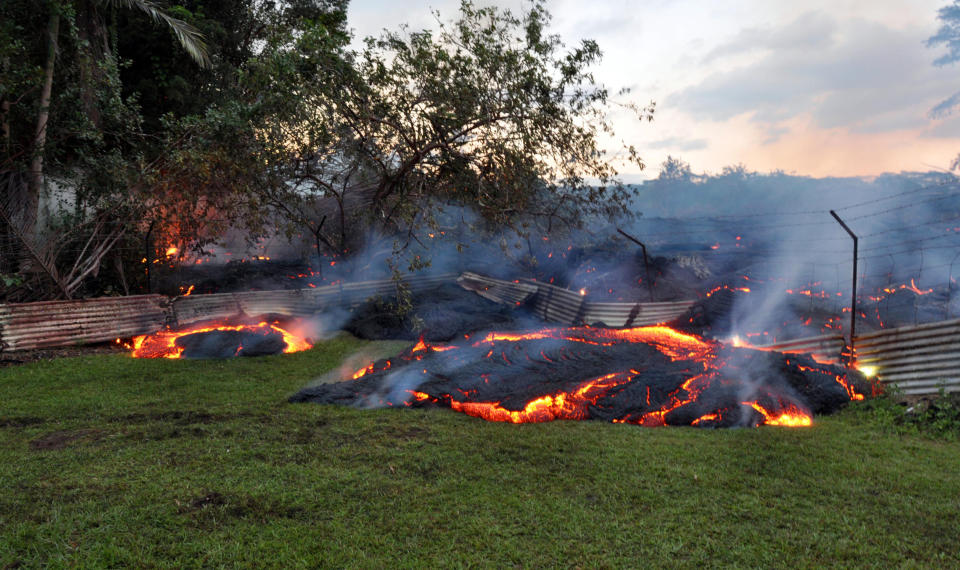
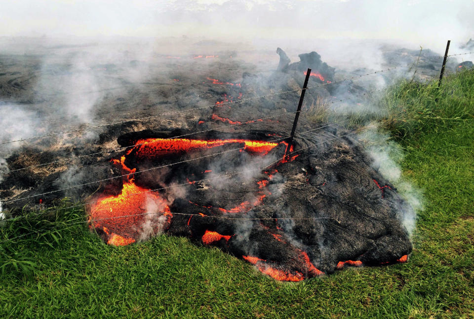
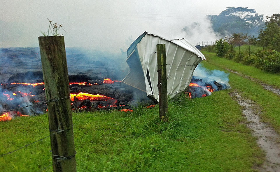
This Tuesday, Oct. 28, 2014 photo provided by the U.S. Geological Survey shows lava that has pushed through a fence marking a property boundary above the town of Pahoa on the Big Island of Hawaii. After weeks of slow, stop-and-go movement, a river of asphalt-black lava was less than the length of a football field from homes in the Big Island community Tuesday. The lava flow easily burned down an empty shed at about 7:30 a.m., several hours after entering a residential property in Pahoa Village, said Hawaii County Civil Defense Director Darryl Oliveira. A branch of the molten stream was less than 100 yards (90 meters) from a two-story house. It could hit the home later Tuesday if it continues on its current path, Oliveira estimated. Residents of Pahoa Village, the commercial center of the island's rural Puna district south of Hilo, have had weeks to prepare for what's been described as a slow-motion disaster. Most have either already left or are prepared to go. (AP Photo/U.S. Geological Survey)
This Tuesday, Oct. 28, 2014 photo provided by the U.S. Geological Survey shows lava that has pushed through a fence marking a property boundary above the town of Pahoa on the Big Island of Hawaii. After weeks of slow, stop-and-go movement, a river of asphalt-black lava was less than the length of a football field from homes in the Big Island community Tuesday. The lava flow easily burned down an empty shed at about 7:30 a.m., several hours after entering a residential property in Pahoa Village, said Hawaii County Civil Defense Director Darryl Oliveira. A branch of the molten stream was less than 100 yards (90 meters) from a two-story house. It could hit the home later Tuesday if it continues on its current path, Oliveira estimated. Residents of Pahoa Village, the commercial center of the island's rural Puna district south of Hilo, have had weeks to prepare for what's been described as a slow-motion disaster. Most have either already left or are prepared to go. (AP Photo/U.S. Geological Survey)
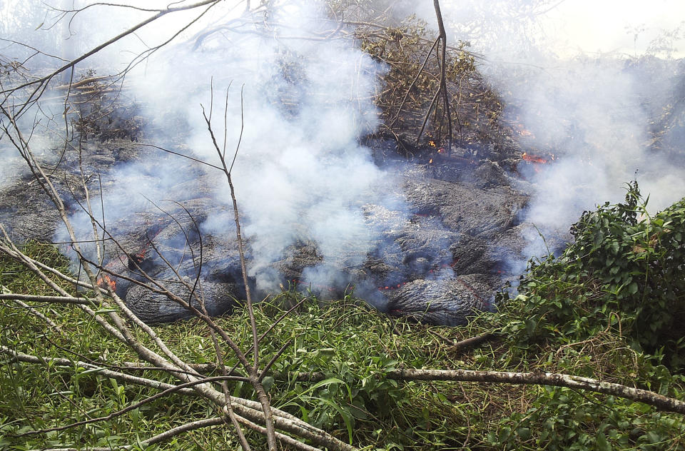
In this Oct. 27, 2014 photo provided by the U.S. Geological Survey, lava flow from Kilauea Volcano that began on June 27 burns through thick vegetation below the pasture downslope of the Pahoa cemetery near the town of Pahoa on the Big Island of Hawaii. Residents of the small town have had weeks to prepare for what's been described as a slow-motion disaster. County officials are making arrangements for those living in the lava's path to be able to watch the lava destroy their homes as a means of closure. (AP Photo/U.S. Geological Survey)
This Tuesday, Oct. 28, 2014 photo provided by the U.S. Geological Survey shows lava burning vegetation as it approaches a property boundary above the town of Pahoa on the Big Island of Hawaii. After weeks of slow, stop-and-go movement, a river of asphalt-black lava was less than the length of a football field from homes in the Big Island community Tuesday. The lava flow easily burned down an empty shed at about 7:30 a.m., several hours after entering a residential property in Pahoa Village, said Hawaii County Civil Defense Director Darryl Oliveira. A branch of the molten stream was less than 100 yards (90 meters) from a two-story house. It could hit the home later Tuesday if it continues on its current path, Oliveira estimated. Residents of Pahoa Village, the commercial center of the island's rural Puna district south of Hilo, have had weeks to prepare for what's been described as a slow-motion disaster. Most have either already left or are prepared to go. (AP Photo/U.S. Geological Survey)
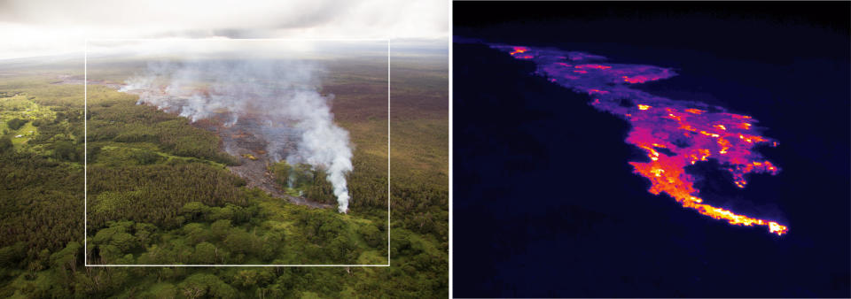
This pair of images released Oct. 22, 2014 by the U.S. Geological Survey shows a comparison of a normal photograph of the lava flow front, left, with a thermal image of the flow that is threatening the town of Pahoa on the Big Island of Hawaii. The white box shows the approximate extent of the thermal image. The thermal image shows that active breakouts (white and yellow areas) are focused along the narrow lobe at the leading edge of the flow, but are also scattered for about 2 km (1.2 miles) behind the flow front. Authorities on Sunday, Oct. 26, 2014 said lava had advanced about 250 yards since Saturday morning and was moving at the rate of about 10 to 15 yards an hour, consistent with its advancement in recent days. The flow front passed through a predominantly Buddhist cemetery, covering grave sites in the mostly rural region of Puna, and was roughly a half-mile from Pahoa Village Road, the main street of Pahoa. (AP Photo/U.S. Geological Survey)
This Oct. 25, 2014 photo provided by the U.S. Geological Survey shows lava flow advancing across the pasture between the Pahoa cemetery and Apaa Street, engulfing a barbed wire fence, near the town of Pahoa on the Big Island of Hawaii. Dozens of residents in this rural area of Hawaii were placed on alert as flowing lava continued to advance. Authorities on Sunday, Oct. 26, 2014 said lava had advanced about 250 yards since Saturday morning and was moving at the rate of about 10 to 15 yards an hour, consistent with its advancement in recent days. The flow front passed through a predominantly Buddhist cemetery, covering grave sites in the mostly rural region of Puna, and was roughly a half-mile from Pahoa Village Road, the main street of Pahoa. (AP Photo/U.S. Geological Survey)
This Oct. 26, 2014 photo provided by the U.S. Geological Survey shows the lava flow front of from an eruption that began the June 27, as the front remains active and continues to advance towards the northeast threatening the town of Pahoa on the Big Island of Hawaii. Dozens of residents in this rural area of Hawaii were placed on alert as flowing lava continued to advance. Authorities on Sunday, Oct. 26, 2014 said lava had advanced about 250 yards since Saturday morning and was moving at the rate of about 10 to 15 yards an hour, consistent with its advancement in recent days. The flow front passed through a predominantly Buddhist cemetery, covering grave sites in the mostly rural region of Puna, and was roughly a half-mile from Pahoa Village Road, the main street of Pahoa. (AP Photo/U.S. Geological Survey)
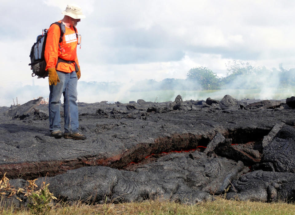
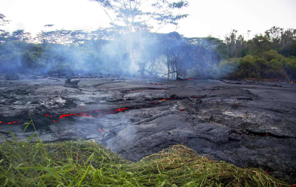
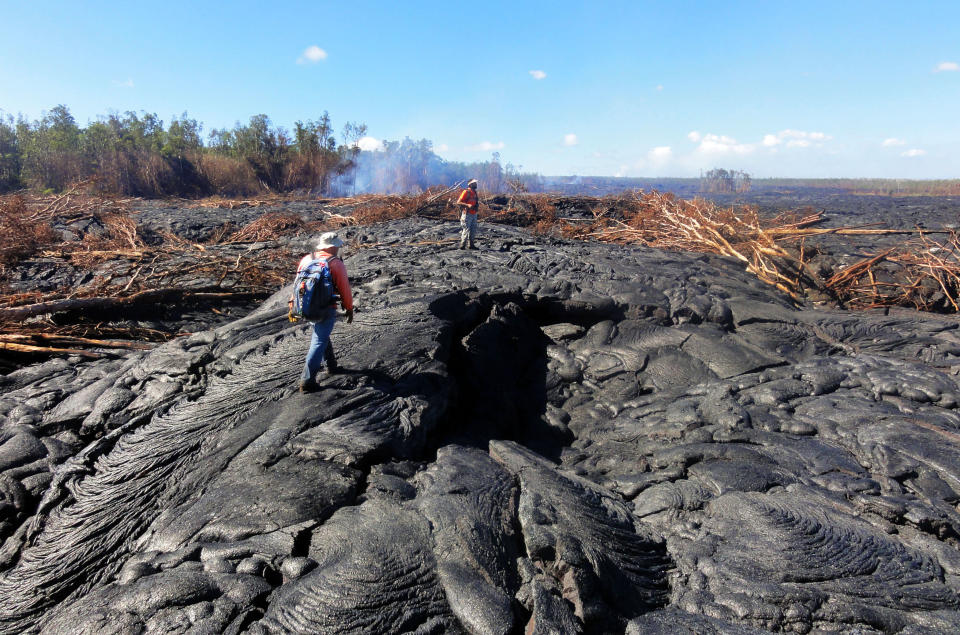
This Oct. 25, 2014 photo provided by the U.S. Geological Survey shows a Hawaii Volcano Observatory geologist standing on a partly cooled section of lava flow near the town of Pahoa on the Big Island of Hawaii. Note the thin red horizontal line of molten lava visible along the bottom third of the photo. The flow here is about one meter (three feet) thick, but slightly farther upslope where the lava has had more time to inflate the thickness was closer to two meters. Dozens of residents in this rural area of Hawaii were placed on alert as flowing lava continued to advance. Authorities on Sunday, Oct. 26, 2014 said lava had advanced about 250 yards since Saturday morning and was moving at the rate of about 10 to 15 yards an hour, consistent with its advancement in recent days. The flow front passed through a predominantly Buddhist cemetery, covering grave sites in the mostly rural region of Puna, and was roughly a half-mile from Pahoa Village Road, the main street of Pahoa. (AP Photo/U.S. Geological Survey)
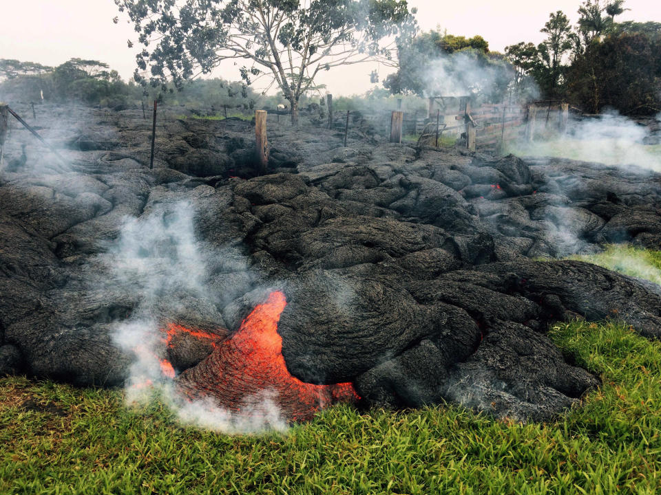
This Oct. 25, 2014 photo provided by the U.S. Geological Survey shows a small shed being consumed by lava in a pasture between the Pahoa cemetery and Apa?a Street near the town of Pahoa on the Big Island of Hawaii. Dozens of residents in this rural area of Hawaii were placed on alert as flowing lava continued to advance. Authorities on Sunday, Oct. 26, 2014 said lava had advanced about 250 yards since Saturday morning and was moving at the rate of about 10 to 15 yards an hour, consistent with its advancement in recent days. The flow front passed through a predominantly Buddhist cemetery, covering grave sites in the mostly rural region of Puna, and was roughly a half-mile from Pahoa Village Road, the main street of Pahoa. (AP Photo/U.S. Geological Survey)
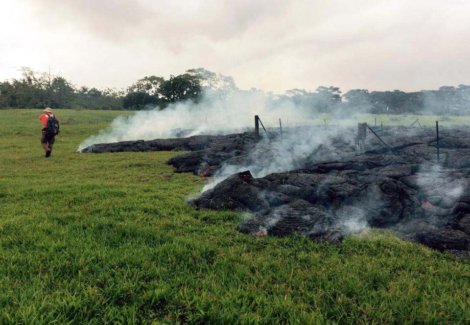
This Oct. 26, 2014 photo provided by the U.S. Geological Survey a Hawaii Volcano Observatory geologist mapping the margin of the June 27 lava flow in the open field below Cemetery Road near the town of Pahoa on the Big Island of Hawaii. Dozens of residents in this rural area of Hawaii were placed on alert as flowing lava continued to advance. Authorities on Sunday, Oct. 26, 2014 said lava had advanced about 250 yards since Saturday morning and was moving at the rate of about 10 to 15 yards an hour, consistent with its advancement in recent days. The flow front passed through a predominantly Buddhist cemetery, covering grave sites in the mostly rural region of Puna, and was roughly a half-mile from Pahoa Village Road, the main street of Pahoa. (AP Photo/U.S. Geological Survey)
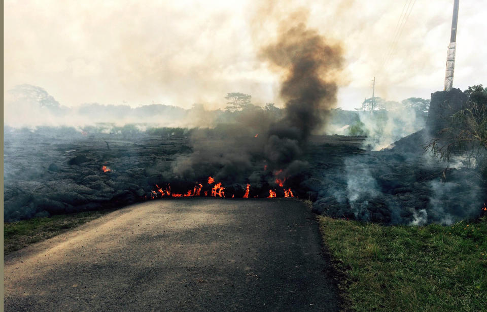
In this Oct. 24, 2014 photo from the U.S. Geological Survey, the lava flow from Kilauea Volcano that began June 27 is seen as it crossed Apa?a Street near Cemetery Road near the town of Pahoa on the Big Island of Hawaii. Hawaii authorities on Saturday told several dozen residents near the active lava flow to prepare for a possible evacuation in the next three to five days as molten rock oozed across the country road and edged closer to homes. The USGS says the flow is currently about 160 to 230 feet (50 to 70 meters) wide and moving northeast at about 10 yards (nine meters) per hour. It's currently about six-tenths of a mile (one kilometer) from Pahoa Village Road, the town's main street. (AP Photo/U.S. Geological Survey)
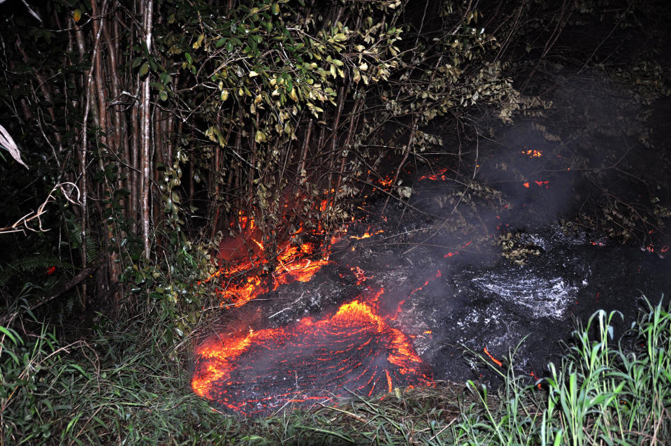
This Oct. 22, 2014 photo provided by the United States Geological Survey shows lava flow slowly moving through thick vegetation and creating thick plumes of smoke as it advances on the town of Pahoa on the Big Island of Hawaii. Frequent methane explosions occur, resulting from cooked vegetation releasing methane which then ignites. The explosions can range from small puffs to loud cannon-like blasts, and are an additional hazard in the immediate area of the flow margin. (AP Photo/U.S. Geological Survey)
In this Oct. 22, 2014 photo provided by the United States Geological Survey, Hawaii Volcano Observatory geologists walk over the surface of the flow to track surface breakouts along a portion of the flow margin, about a kilometer (0.6 miles) upslope of the flow front, as the lava advances on the town of Pahoa on the Big Island of hawaii. Scorched and burned trees are seena t rear. The growing stream of lava threatening homes is expanding and speeding up as it heads toward the small rural town. Officials say the lava advanced nearly 460 yards from Thursday morning to Friday, Oct. 24, 2014. (AP Photo/U.S. Geological Survey)
Affluent Americans may want to double-check how much of their bank deposits are protected by government-backed insurance. The rules governing trust accounts just changed.
Former NBA guard Darius Morris has died at the age of 33. He played for five teams during his four NBA seasons. Morris played college basketball at Michigan.
Teams have made their big splashes in free agency and made their draft picks, it's time for you to do the same. It's fantasy football mock draft time. Some call this time of year best ball season, others know it's an opportunity to get a leg up on your competition for when you have to draft in August. The staff at Yahoo Fantasy did their first mock draft of the 2024 season to help you with the latter. Matt Harmon and Andy Behrens are here to break it all down by each round and crush some staff members in the process.
With free agency and the draft behind us, what 32 teams look like today will likely be what they look like Week 1 and beyond for the 2024 season. Matt Harmon and Scott Pianowski reveal the post-draft fantasy power rankings. The duo break down the rankings in six tiers: Elite offensive ecosystems, teams on the cusp of being complete mixed bag ecosystems, offensive ecosystems with something to prove, offenses that could go either way, and offenses that are best to stay away from in fantasy.
It’s key to note that we’re not saying the “best team” or “best roster.” Instead, we’re talking about the best confluence of factors that can outline a path for survival and then success.
In the most anticlimactic way possible, Nintendo on Tuesday confirmed years of rumors: The Nintendo Switch 2 console is on the way. "We will make an announcement about the successor to Nintendo Switch within this fiscal year," wrote Shuntaro Furukawa, the president of Nintendo, on X. Rather, Furukawa wanted to warn users not to expect the actual announcement in next month's Nintendo Direct livestream.
An annual government report offered a glimmer of good news for Social Security and a jolt of good news for Medicare even as both programs continue to be on pace to run dry next decade.
The 2023-024 NBA season isn't yet over. A number of teams are still dreaming of championship glory. But for those that have been bounced from the playoffs, it's time to reassess and re-evaluate for next season.