Advertisement

Tornadoes rip through South: Forecast and what to expect

Thirty million Americans are on alert for severe weather as tornadoes slam the South on Wednesday.

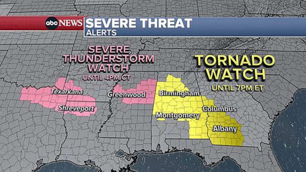
A tornado watch is in effect for Georgia and Alabama, where two tornadoes have already been reported, and severe thunderstorm watches have been issued for much of central Mississippi.

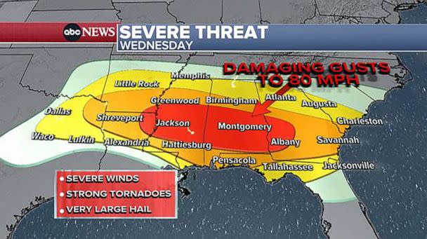
Wind gusts up to 90 mph and huge hail are also in the forecast.

PHOTO: A tornado is seen in a still from video in Abbeville, Alabama on June 14, 2023. (Bradley Bedwell)
PHOTO: Damage to home in Abbeville, Alabama, June 14, 2023. (Bradley Bedwell)

MORE: Air quality concerns in US will continue through summer due to Canada's wildfires

The bull's-eye will be from Jackson, Mississippi, to Montgomery, Alabama, to Albany, Georgia.

But the severe weather could stretch as far west as Dallas and as far east as Savannah, Georgia.

PHOTO: Severe weather outbreak expected tonight with intense wind gusts the main threat from Texas to Georgia. Some strong tornadoes are also possible. (ABC News)
PHOTO: A severe threat level 4 out of 5 is issued from Louisiana to Georgia, with cities such as Jackson, Montgomery, Dothan, Columbus, and Albany in the crosshairs of the worst of the storms – including the severe winds to 80mph and strong tornadoes. (ABC News)

On Thursday, the threat for hail and winds will be in two pockets: one in Kansas and Oklahoma, and another along the Gulf Coast from Alabama to Florida.

PHOTO: Tomorrow there will be two pockets for the potential of severe weather from the central and southern Plains to the Gulf Coast – including Wichita, OKC, Dallas, Mobile, and Tallahassee. (ABC News)

The South is also facing dangerous heat.

ADVERTISEMENT

On Tuesday, McAllen, Texas, hit a record high of 103 degrees.

On Wednesday afternoon the heat index -- what temperature it feels like with humidity -- could soar to 104 degrees in San Antonio, 105 in Houston and a scorching 114 in Corpus Christi, Texas.

PHOTO: In the meantime, we are also tracking the developing pro-longed heat wave in Texas. Heat Advisories and Excessive Heat Warnings are in effect today and the heat index will soar over 110-115+ degrees! (ABC News)

MORE: Extreme heat safety tips: What to know about heat stroke vs. heat exhaustion

By Saturday, the heat index is forecast to climb to a dangerous 108 degrees in Dallas and 111 degrees in San Antonio and Houston.

Click here for tips on how to stay safe in the heat.

Tornadoes rip through South: Forecast and what to expect originally appeared on abcnews.go.com