Winter Storm Watch issued: Nor'easter could bring 18 inches of snow, knock out power
The National Weather Service has issued a Winter Storm Watch for a storm Friday into Saturday that could bring more than a foot of snow, 60-mph winds and coastal flooding.
"A powerful coastal storm remains in the forecast Saturday and Saturday night, which will likely impact at least a portion of the region with heavy snow, strong winds, coastal flooding and dangerous seas," the Weather Service says.
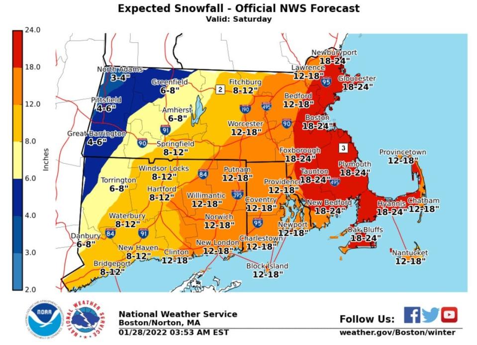
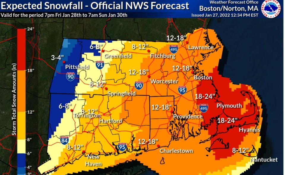
An updated National Weather Service map issued at 12:34 p.m. Thursday shows Rhode Island getting 12 to 18 inches, Cape Cod and Plymouth, Massachusetts, getting 18 to 24 inches. A previous Weather Service map, issued around 4 a.m., had shown most of Rhode Island getting 8 to 12 inches.
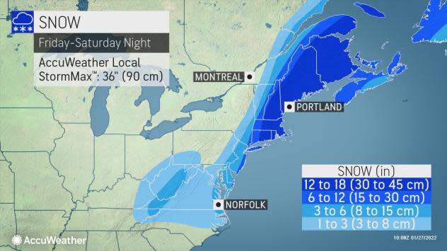
Questions remain about the exact track of the storm, but on Thursday morning, an AccuWeather map was showing Rhode Island, southeastern Massachusetts and eastern Connecticut in the hardest-hit zone, getting 12 to 18 inches of snow.
More: Can you guess how much snow Providence got on its snowiest day? Here's a look at history
"A still-developing winter storm is set to become a major nor’easter that will bombard New England with heavy snow and blizzard conditions this weekend," AccuWeather said.
With snowfall rates of 1 to 3 inches per hour and "extensive blowing and drifting," the storm will probably snarl travel, force flight cancellations and could strand people in their cars, AccuWeather said.
The storm's high winds could knock out power and astronomical high tides will contribute to coastal flooding, according to forecasters.
More: Does your town have a parking ban? Here's where to leave your car during a snowstorm in RI
For now at least, the National Weather Service expects the most significant snowfall will be over "southeast Massachusetts, diminishing to the northwest."
Computer models on Wednesday showed the storm moving to the east but on Thursday "ticked back west; a windshield-wiper effect we often see in computer models leading up to these events and why you don't want to hang your hat on one deterministic model run," the Weather Service said.
A significant shift to the west would put the heavier snow further inland, while a strong shift to the east could leave the worst of it out over the ocean.
More: Wanna have a snowball fight? Watch out — it's illegal in 8 cities and towns in Rhode Island
"This remains a decidedly chaotic forecast with decent run-to-run consistency in some models/ensembles, but large model-to-model discrepancies," the Weather Service said.
While they still have questions about the track, forecasters agree that the storm is likely to strengthen rapidly as it moves up the coast "likely undergoing bombogenesis, meaning its central pressure drops at least 24 (millibars) in 24 hours," the National Weather Service says. "This will bring the threat of significant snow, potentially damaging winds and coastal flooding."
The strongest winds are expected over Cape Cod and the islands, according to the National Weather Service.
"Coastal flooding is the final threat we`re concerned about," the Weather Service said. "This would be during both high tide cycles on Saturday, but more so in the evening."
The storm should generate 20- to 25-foot seas, and the evening high tide surge should be more than 3 feet, leading to minor and moderate coastal flooding, according to the Weather Service.
jperry@providencejournal.com
(401) 277-7614
On Twitter: @jgregoryperry
Be the first to know.
Sign up for our breaking news alerts
This article originally appeared on The Providence Journal: Winter storm update: Rhode Island is in the 12- to 18-inch snow zone

