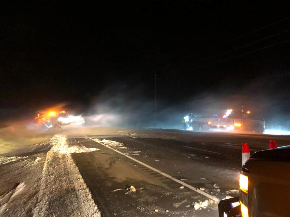
Whiteout conditions, drifting snow in outlying areas near Tri-Cities. Drivers stranded
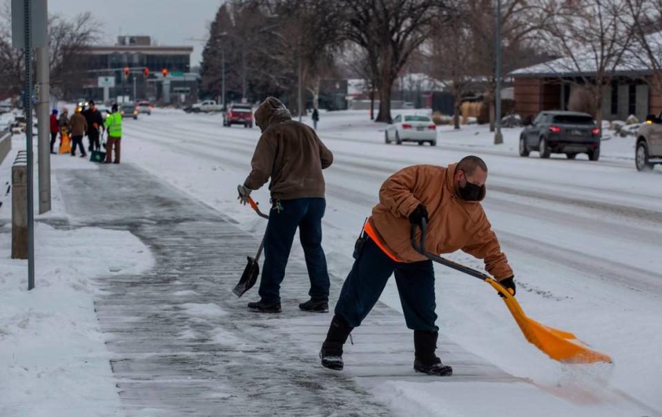
A winter weather advisory was issued as more snow fell in the Tri-Cities on Monday morning and the National Weather Service forecast a wintery mix of snow and freezing rain.
During the advisory through 3 p.m. Monday some areas of the lower Columbia Basin were expected to get up to two inches of snow and ice accumulations of a tenth of an inch.
In the Tri-Cities less than an inch of snow and less than a tenth of an inch of ice were forecast.
The storm system also brought high winds and whiteout conditions to surrounding areas.
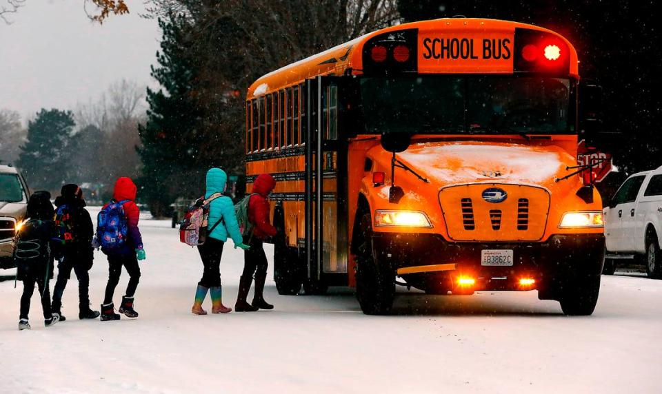
While Tri-Cities schools opened on time Monday after the holiday break, but many schools in outlying area were closed due to the hazardous road conditions.
Students in the Prescott, Waitsburg, Grandview and Sunnyside school districts were among those who got an extra day off Monday.
The Mid-Columbia Libraries closed all branches at 1 p.m. Monday.
Franklin County closed county offices, including the courthouse, at noon due to road conditions after freezing rain began to fall in parts of the county mid morning.
The Benton County courthouse remained open.
The Hanford site started sending environmental cleanup workers home, both from Richland and the nuclear reservation, early on a staggered schedule that began at 2 p.m. Monday. Swing and graveyard shifts were canceled for workers not essential to safety and security.
West Richland announced plans to close city offices at 3 p.m. and the Benton Franklin Health District closed at 3:30 p.m.
No Benton County roads were closed Monday morning, but Benton County officials were advising people to avoid the Horse Heaven Hills, as crashes were reported on icy roads.
Neither Benton nor Franklin county coroners have reported any deaths due to the arctic cold over the last week.
The Umatilla County Sheriff’s Office reported the body of Gary H. Russell, 76, was discovered Monday morning after the body lay in a Hermiston driveway near a vehicle for an extended period of time.
No cause of death has been released. There were no signs of foul play, the sheriff’s office said.
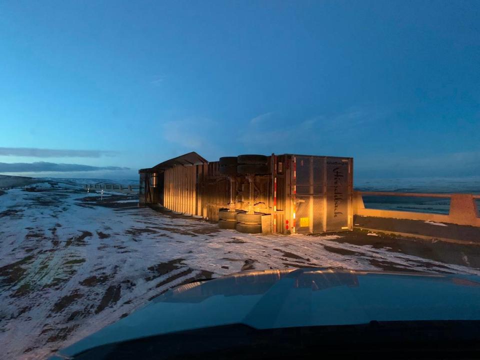
Travelers to and from the Tri-Cities across the Cascade and Blue mountains were having a tough time on Monday.
Mid-Columbia School Delays & Closures
About 70 miles of Interstate 90 from North Bend to Ellensburg closed before 2 a.m. Monday due to blowing snow, zero visibility and avalanche concerns, according to the Washington state Department of Transportation.
Officials did not plan to reopen the interstate until 8 p.m. Monday. They warned that power outages had reduced the number of traffic cameras in use.
White Pass on Highway 12 was closed Monday due to snow slides.
East of the Tri-Cities westbound and eastbound lanes closed about 5:30 a.m. from six miles east of Pendleton to Baker City after also being closed for part of Sunday.
Westbound trucks were being stopped at Ontario, Ore.
The interstate reopened about 2:30 p.m., but other roads in Eastern Washington remained closed.
The Oregon Department of Transportation was advising no travel in Umatilla County across the state line from Benton County due to high winds, whiteout conditions and numerous snow drifts across roadways.
“Conditions are so extreme that snow plow drivers cannot see the road well enough to effectively plow snow,” the Oregon Department of Transportation said. “Plowing operations may be postponed on some closed state routes in Umatilla County.”
Highway 11 in Oregon from Walla Walla to Pendleton was closed Monday, along with Highway 204, the Tollgate Highway.
Road closures could remain in place for several days on some routes as more snow and high winds were expected Monday, it said.
However, some drivers were ignoring road closures and becoming stranded, said the Oregon Department of Transportation.
It warned that drivers who get stuck on closed roadways or in snowdrifts may not be rescued until weather conditions improved, which might take days.
“Don’t put emergency responders and others in danger by driving in severe weather,” it said.
If you do drive in Eastern Oregon, plan for long delays and pack extra food, water and blankets, it said.
In Walla Walla County the sheriff’s office asked that people stay home except in an emergency just before midnight Sunday.
Snow drifts, coupled with ice and compacted snow, were making county roads impassable and some cars were stuck in deep drifts, it posted on social media.
Monday afternoon the county released a list of roads with all or some portions that were impassable. They included Buroker, Clodius, Cottonwood, the end of Powerline, Hart, Hood, Lewis Peak, Lewiston, Londagin, Luckenbill, McCown, Mud Creek, Seaman, Smith, Waggoner and Walker.
Tri-Cities forecast
More rain, freezing rain and snow is possible this week, making more hazardous road conditions likely, with some of the worst forecast for Thursday.
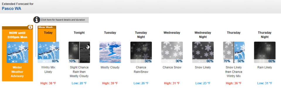
After Monday, snow, more snow also is likely Wednesday, with chances increased from 30% after 4 p.m. to 60% after 10 p.m.
New snow measuring 1 to 2 inches is possible Wednesday night, according to the weather service.
Snow could continue on Thursday, changing to a wintery mix of snow and freezing rain Thursday night .
Friday rain is expected, with a chance of rain and snow Friday night, before the weather clears for the weekend. Saturday could be the warmest day of the week with a high of 40, according to the weather service forecast.
Rain was forecast Friday, followed by a dry weekend.
The worst of the cold snap created by Arctic air is behind the Tri-Cities.
Highs should be above freezing each day this week, except for a high of 31 forecast for Wednesday.
Lows will increase to the 20s through Wednesday night and could be as warm as 30 on Thursday night and 32 on Friday night.
Travel forecast
Travelers across the Cascade Mountains in Washington will need to pick their travel window carefully this week, or consider staying home or flying.
Four to 8 inches of new snow were forecast Monday on I-90 at Snoqualmie Pass, with another 3 to 5 inches possible overnight.
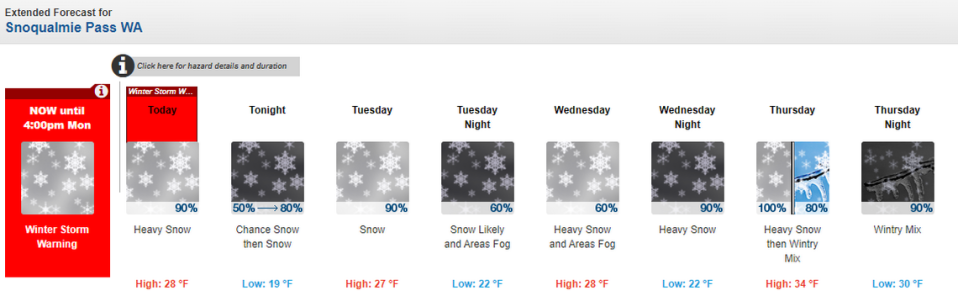
Tuesday 3 to 7 inches were forecast for the daytime, followed by 3 to 5 inches Monday night.
Wednesday just 2 to 4 inches were forecast during the day, but the pass was forecast to be wallowed with 12 to 18 inches of new snow that night.
Another 9 to 13 inches could fall on Thursday.
On Friday a wintery mix of snow and freezing rain could make driving difficult in the morning.
A snowy week also is forecast for I-84 east of the Tri-Cities through Oregon, with a winter storm warning issued through at least 4 p.m. Tuesday.
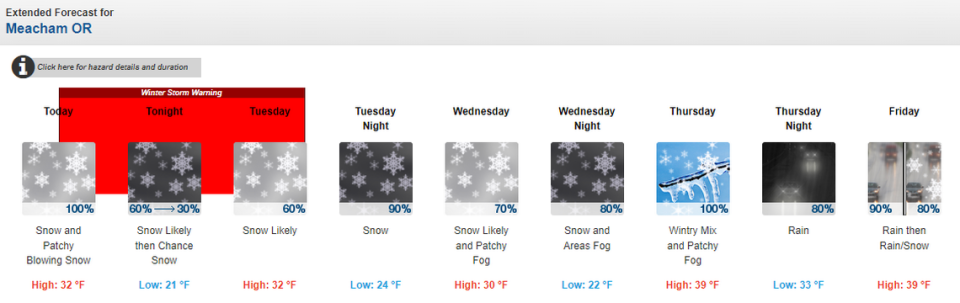
Monday 2 to 4 inches of fresh snow were forecast with another 1 to 3 inches both Monday night and again Tuesday at Meacham about 30 miles east of Pendleton.
Tuesday night could see some of the heaviest snow of the week with 3 to 7 inches of snow possible.
Wednesday and Wednesday night snowfall could total 3 to 7 inches.
Thursday morning could be particularly hazardous for drivers with a wintery mix of snow and freezing rain forecast along with fog.
Snow and freezing rain also were forecast for Friday night.
This report will be updated as weather conditions change and any additional closures are announced.

