Tropical Storm Ian: What can Jacksonville expect and prepare for ahead of the storm?
- Oops!Something went wrong.Please try again later.
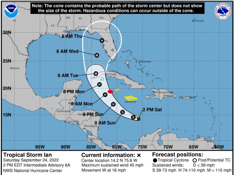
Tropical Storm Ian continued to develop Saturday in the Southern Caribbean Sea and intensify into "a major hurricane" over the weekend as it comes into the Southeast Gulf of Mexico toward a potential landfall on Florida's West Coast.
Gov. Ron DeSantis extended a state of emergency Saturday afternoon for all 67 Florida counties in preparation for Ian, the Palm Beach Post reported.
“The threat posed by Tropical Storm Ian requires that timely precautions are taken to protect the communities, critical infrastructure, and general welfare of Florida,” the governor said in his amended executive order issued Saturday afternoon, according to the newspaper.
It's still too soon to pinpoint Ian's path or predict with any certainty where it's likely to make landfall, according to meteorologists at the National Weather Service in Jacksonville.
But it is predicted to be at least a Category 3 or higher storm as it tracks northward very close to the Florida Gulf Coast Region, NWS meteorologist Angie Enyedi, told the Times-Union.
Ian intensifying: With Ian incoming, Florida may see its most serious hurricane threat in years | WeatherTiger forecast
Jacksonville's message is clear: 'Don't be complacent' in preparing for another busy hurricane season
A long time coming: Jacksonville Beach Pier reopens after 3 years of hurricane damage repairs
The Weather Service and emergency management authorities in Jacksonville as well as neighboring Northeast Florida counties are monitoring the storm closely.
"It could be here as early as Tuesday night but more likely on Wednesday," she said.
Enyedi said it's time to prepare, "not freak out and panic."
Residents should keep tabs on Ian via the National Hurricane Center and local Emergency Management authorities, she said.
If they haven't already done it, people should assemble their hurricane kits, know their evacuation zones and already have decided whether they will evacuate or shelter in place.
The American Red Cross recommends the following preparations
Gather food, water, and medicine. Organize supplies into a Go-Kit and a Stay-at-Home Kit.
Go-Kit: 3 days of supplies that you can carry with you. Include backup batteries and chargers for your devices (cell phone, CPAP, wheelchair, etc.)
Stay-at-Home Kit: 2 weeks of supplies. Stores and pharmacies might be closed.
Have a 1-month supply of medication in a child-proof container.
Keep personal, financial, and medical records safe.
People should be prepared for potential flooding, power outages lasting several days, and high winds downing trees.
"Ian is one to prepare for… yes the worst will be on the west coast of Florida, but we have the potential of an Irma Type event here … late Wednesday- Friday," tweeted Tim Deegan. meteorologist with Times-Union news partner First Coast News.
AnneMarie Jefferson came out with two gallons of bottled water, toilet paper and snacks and a bag of apples in her cart Saturday morning at Walmart on San Jose Boulevard.
"It's just in case. I already had most of my hurricane stuff already like batteries and canned goods, but I'd rather have too much cause you never know what's going to happen," Jefferson said.
Enyed said it's too soon to say with any specificity how strong the winds will be or how much rain will fall on Jacksonville and the rest of Northeast Florida.
The National Hurricane Center showed the storm "trending a little bit west" with each forecast cycle every six hours.
Enyedi said as Ian enters the Gulf, coastal conditions will deteriorate even over adjacent Atlantic waters and beaches — especially Tuesday night, Wednesday and Thursday. That will result in hazards including frequent rip currents, large surf, gusting winds and possible rain bands coming ashore.
As Ian continues on the northward track across the Eastern Gulf, it would put Jacksonville and Northeast Florida counties on the eastern — very wet side — of the storm, she said.
"The potential for some very heavy rainfall, flooding rainfall could be there," Enyedi said.
This article originally appeared on Florida Times-Union: Tropical Storm Ian: Jacksonville urged to prepare ahead of hurricane

