Tornado warnings replaced with tornado watch for several North Florida counties
Severe thunderstorms moving east at 40 mph
11:14 a.m.: A severe thunderstorm warning is in effect for portions of Wakulla, Jefferson, Taylor, Leon, Franklin and Madison counties until 12:15 p.m.
At 11:13 a.m. ET, severe thunderstorms were located along a line extending from 11 miles northeast of Woodville to 6 miles southeast of Carrabelle, moving east at 40 mph.
Hazards include 60-mph wind gusts, which could damage roofs, siding and trees.
In the dark:Extremely dangerous' tornado slams Texas; storms sweep across Florida
Tornado watch extended until noon for 5 counties
10:22 a.m.: A tornado watch previously in effect until 11 a.m. has been extended until noon for Franklin, Jefferson, Leon, Liberty and Wakulla counties.
Radar confirms tornado near Florida A and M
Two Tornado Warnings (bright red) are in effect for the Tallahassee, Florida area, both with radar-confirmed tornadoes. Residents should take cover. pic.twitter.com/F0tLlh08uB
— Breaking Weather by AccuWeather (@breakingweather) January 25, 2023
10:31 a.m.: A tornado-producing storm was located near Florida A and M, or 7 miles southwest of Tallahassee, moving northeast at 35 mph. Radar confirmed a tornado.
This tornadic storm will be near Florida A and M, Florida State University and Doak Campbell Stadium around 10:40 a.m. ET and Tallahassee around 10:45 a.m.
Other locations impacted by this tornadic thunderstorm include: Ralford Greenway, Macon Community Park, Gaither Community Center, Lake Munson, Tallahassee Memorial Hosp, Killearn Estates, Lake Ella, Tallahassee Mall, State Capital Complex and Governors Square Mall.
Tornado warning issued for Leon, Jefferson counties

10:27 a.m.: A tornado warning has been issued for west central Jefferson County and southeastern Leon County until 11 a.m.
At 10:24 a.m., a severe thunderstorm capable of producing a tornado was located 8 miles north of Crawfordville, moving east at 35 mph. Radar indicated rotation.
The National Weather Service Tallahassee is reporting a confirmed tornado near Belair and Four Points, moving northeast. It's expected to be near Tallahassee at 10:48 a.m. FSU and FAMU campuses are in the path. Residents are advised to take shelter immediately.
Other locations impacted by this tornadic thunderstorm include: Apalachee Regional Park, Cody, Chaires, Leon Sinks, Southwood, Chaires Crossroads, Lutterloh, Eight Mile Pond and Capitola.
Fast-moving storms bringing damaging winds, risk for tornadoes
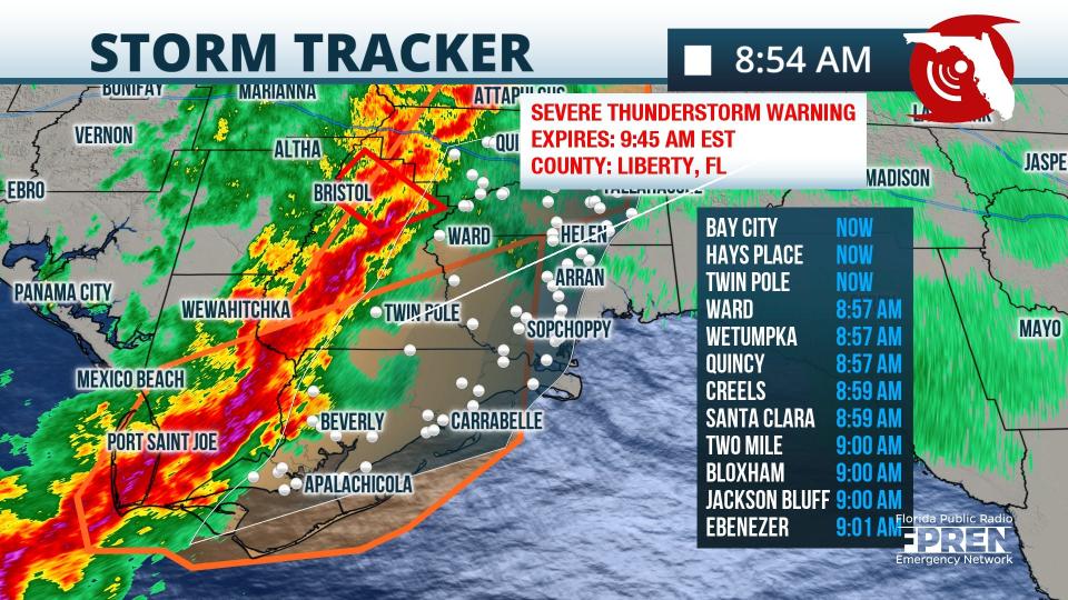
8:54 a.m.: Strong and severe storms continue to move through the central Panhandle from Chattahoochee down to Port Saint Joe. Storms are moving very fast with damaging wind and isolated tornado risks.
A tornado watch has been issued for Gadsden, Jefferson, Leon and Wakulla counties until 11 a.m. ET.
Tornado warning issued for three Florida cities
8:52 a.m.: A tornado warning has been issued for Bristol, Hosford and Telogia until 9 a.m. ET.
Severe storms moving toward Tallahassee
7:45AM ET: Severe storms are continuing to move east. The damaging wind threat continues to exist throughout the line with the brief spin-up tornado threat continuing for the FL Panhandle where instability is greatest. Continue to stay weather aware! #flwx #alwx #gawx pic.twitter.com/vN3qqnjM9y
— NWS Tallahassee (@NWSTallahassee) January 25, 2023
7:45 a.m.: Severe storms continue to move east across the Panhandle. The National Weather Service Tallahassee warning "the damaging wind threat continues to exist throughout the line, with the brief spin-up tornado threat continuing."
Tornado warning issued for Gulf, Bay counties
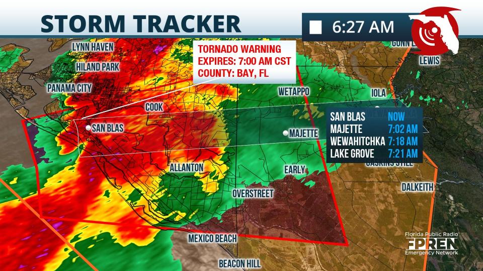
7:22 a.m.: A tornado warning has been issued until 8 a.m. ET for northwestern Gulf County and southeastern Bay County.
At 7:22 a.m., a severe thunderstorm capable of producing a tornado was located near Tyndall Air Force Base, or near Callaway, moving northeast at 40 mph.
Radar has indicated rotation.
This tornadic thunderstorm is forecast to remain over mainly rural areas of northwestern Gulf and southeastern Bay Counties, including the following locations: Overstreet, Beacon Beach, Wetappo, Davis Beach, Allanton and Parker.
Tornado warning issued for Bay, Calhoun, Washington counties
6:45 a.m.: A tornado warning has been issued for Northeastern Bay County, west central Calhoun County andsoutheastern Washington County. The warning is in effect until 6:15 a.m. CT.
At 5:42 a.m., a severe thunderstorm capable of producing a tornado was located 11 miles northwest of Lynn Haven, moving northeast at 50 mph. Radar indicated rotation.
Tornado warning issued for portions of Bay, Walton, Washington counties
6:21 a.m.: Another tornado warning has been issued for Northwest Bay, Southeast Walton and Southwest Washington counties. The warning is in effect until 5:45 a.m. CT.
At 5:18 a.m., a confirmed tornado was located 14 miles east of Santa Rosa Beach, moving northeast at 55 mph.
Locations impacted include: Ebro, Bruce, Red Head, Inlet Beach, Pine Log and Seminole Hills.
Tornado warning issued for SE Walton County
6:05 a.m.: A tornado has been confirmed on the ground near Santa Rosa Beach, moving northeast at 40 mph.
A tornado warning is in effect until 5:30 a.m. CT for southeastern Walton County.
Locations impacted include: Santa Rosa Beach, Eglin Air Force Base, Freeport, Port Washington, Bunker, Grayton Beach, Blue Mountain Beach, Seagrove Beach, Seaside, Rock Hill and Bruce.
Forecasters urge residents to take immediate cover. Move to an interior room or lowest floor of a sturdy building and avoid windows. Tornadoes are extremely difficult to see and confirm at night. Do not wait to see or hear the tornado.
Torrential rainfall also is occurring with this storm, and may lead to flash flooding.
High wind warning issued
4:31 a.m.: A high wind warning is in effect until 6 a.m. CT, with winds of to 30 mph and gusts up to 45 mph expected. Florida counties included in the warning area include: Escambia County, Santa Rosa County and Okaloosa County.
Damaging winds could blow down trees and power lines. Widespread power outages are expected. Travel will bedifficult, especially for high-profile vehicles.
Potential for tornadoes: Escambia, Santa Rosa cancel after-school activities ahead of severe storms
Expect 'particularly windy' conditions: Strong storms with 'particularly windy' conditions possible Wednesday in Tallahassee
Cold front following severe storms
Forecasters warned residents Tuesday powerful thunderstorms were forecast to arrive Tuesday night and into this morning. The storms could bring damaging winds and tornadoes.
Tuesday night's storm will likely bring 70 mph winds and potential EF-2 tornadoes, according to meteorologist Jonathan Howell.
School districts in both Escambia and Santa Rosa counties canceled after-school activities Tuesday night due to the threat of severe weather.
After the line of storms moves through the area, cool, dry air will move into place for the end of the week. Highs by Thursday and Friday will fall into the 50s across the Panhandle, with lows likely to fall near freezing through the start of the weekend.
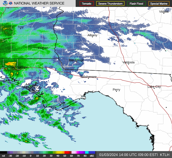
Weather radar for Tallahassee
Follow the National Weather Service Tallahassee on Twitter
Weather radar for Pensacola

Follow National Weather Service Mobile on Twitter
This article originally appeared on Tallahassee Democrat: Tornado warnings, watches issued as storms move across North Florida

