Thanksgiving weather: Cool front brings 20-degree temperature drop Tuesday. How long will it last?
South Florida's warm, muggy and rain-filled days of the past week are over – and just in time for Thanksgiving.
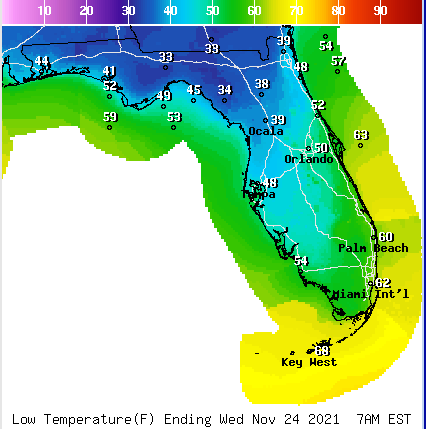
Palm Beach County residents can offer thanks to a cold front that moves in late Monday night, clearing the way for lows in the upper 50s and low 60s and afternoon highs only in the mid-70s. The drop overnight will be close to a 25-degree dip – from Monday's high of 82 to Tuesday's 59-degree temperature around dawn.
The thermometer will struggle to reach 75 on Tuesday.
Black Friday 2021: Our mall dining guide shows you where the good bites are
Did you see the eclipse?: Photos of the partial lunar eclipse captured over Fort Myers Beach
More: Does anyone remember the last cold winter in Palm Beach County?
"This cold front is going to bring a drier and cooler air mass of Canadian air," said Anthony Reynes, a meteorologist with the National Weather Service in Miami. "And of course for Floridians, anything below 70 is considered cold, but this front will bring some of the coolest consistent temperatures for the week."

Reynes said the coldest air will be overnight Tuesday into Wednesday morning with temperatures in the mid- to upper 50s as a low. On Wednesday, the high will again be in the low 70s. Things will slightly warm up on Thanksgiving to the mid-70s.
If you're planning a Thanksgiving dinner outdoors, the weather should cooperate, Reynes said, with only a 10 percent chance of rain – a quick stray shower here and there, if that.
Monday's cold front passing through is actually the second of successive cold fronts that are hitting the area.
"There is a huge mass of high pressure right behind the cold front and that will sit over most of the eastern portion of the U.S. for the week," Reynes said.
Tuesday
High: 73, Low 60
Wednesday
High: 73, Low 65
Thursday
High 76, Low 65
By the end of the week, another weaker front is expected to move through the area, but it will not bring heavy rains, Reynes said.
"The models are showing a weaker front Friday into Saturday that is basically reinforcing the cooler temperatures," he said. "It's what we call a dry front. That will drag some more cool air here. It's cold front season in South Florida."
Climate change: Palm Beach wants more than half a million dollars from state for climate change mitigation
Mystery at sea solved: Beachgoers see odd giant structure float by Palm Beach County's coast
As far as the rest of the 47 states in the continental U.S., some storms along the Atlantic coast will fire up, thanks to the front that is slowly moving across the country. Lower clouds and high winds could create some delays at key airports, including Hartsfield-Jackson Atlanta International, Charlotte Douglas International and any of the New York airports – LaGuardia, JFK or Newark Liberty.
Those high winds, including gusts up to 40 mph, will continue Tuesday and Wednesday across the Atlantic states.
Temperatures will be below average for most of the East Coast this week, with a possibility of hitting the freezing mark in Central Park, according to the New York National Weather Service.
jcoleman@pbpost.com
This article originally appeared on Palm Beach Post: Thanksgiving forecast: Cool front brings lower temperatures to Florida

