State Of Emergency: Flash Flood, Severe Thunderstorm Warnings Issued For Much Of L.A.; Gusts To 70 MPH Expected; More Rain On The Way – Latest
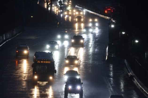
UPDATED 7:30 PM WEDNESDAY: Phones in the L.A. area have exploded with yet another flash flood warning from the National Weather Service. The advisory called it a dangerous and life-threatening situation, and warned residents not to travel unless fleeing a flood area. It extends to 2 a.m.
The National Weather Service also issued a Severe Thunderstorm Warning for the region stretching from Thousand Oaks to Glendale (west to east) and from Santa Clarita to Inglewood (north to south) until 8:45 p.m. “This storm will contain wind gusts to 70 MPH!” reads the NWS statement. It also warns of the potential for pea-sized hail.
More from Deadline
Severe Thunderstorm Warning including Glendale CA, Santa Clarita CA and Thousand Oaks CA until 8:45 PM PST. This storm will contain wind gusts to 70 MPH! pic.twitter.com/q2OmnjftkU
— NWS Los Angeles (@NWSLosAngeles) February 8, 2024
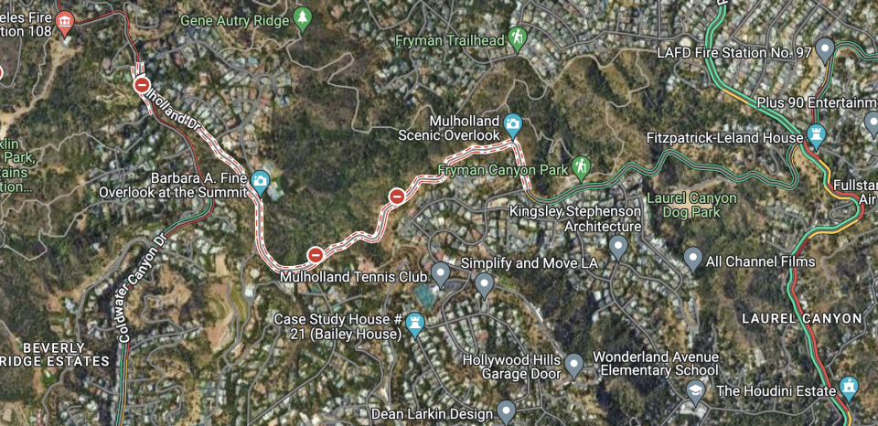
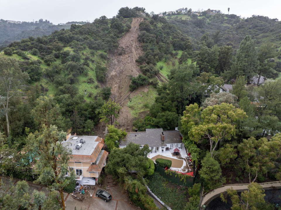
UPDATED with latest: A series of mudslides hit Mulholland Drive today roughly between Coldwater and Laurel Canyons, covering the road with debris and undermining stretches, making it unsafe for vehicles.
The slides severed the major east-west artery in the Hollywood Hills. Commuters and residents are likely looking at an extensive closure of the popular canyon road.
The slides were reported around midday Wednesday, prompting a closure of Mulholland between Skyline and Bowmont drives. Southbound Coldwater Canyon Drive was closed at Mulholland.
Images from the scene showed mud covering several portions of Mulholland, along with sections where the land beneath the roadway had collapsed.
Crumbing hillsides close a stretch of Mulholland Drive. https://t.co/mM6CLMkqa6
— NBC Los Angeles (@NBCLA) February 7, 2024
There were no reports of any injuries.
Numerous big-ticket homes are perched on the hills above the slide area, but it was unclear if any of them were in immediate danger of structural damage.
City Councilwoman Nithya Raman wrote in a statement that the city is responding to “multiple reports (of debris flows) along residential and arterial streets near Laurel Canyon, Coldwater Canyon, Benedict Canyon and Beverly Glen.”
The highest likelihood of mud and debris flows is on hillsides and canyons which can lead to impassable roads,” Raman wrote. “Drivers are advised to avoid these areas which are at heightened risk of mudslides and sudden closures.”
Indeed, city officials said Wednesday that there had been 520 reports of mudslides during the storm event of the past few days.
🌧️ STORM UPDATE 🌧️
Our office is working diligently with LADOT to clear debris and address street closures. In the meantime, please refer to these updates. @LADOTofficial @LADWP @metrolaalerts #LARain pic.twitter.com/JzZ306mQ0a— Councilmember Nithya Raman (@cd4losangeles) February 7, 2024
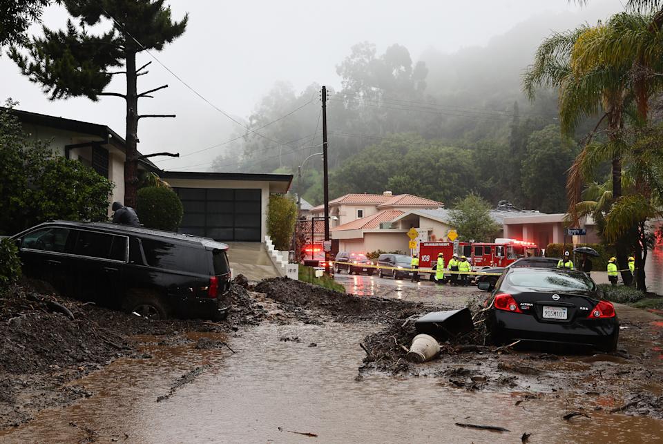
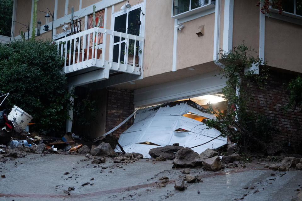
The Mulholland closure is just over the ridge from a major mudslide that occurred during the peak of the storm on Sunday into Monday. It severely damaged six homes and threatened a seventh along Beverly Drive in Beverly Crest. Los Angeles Fire Department crews escorted 15 residents out of the area, including nine children, but no injuries were reported.
Just the other side of Mullholland in Studio City, two homes sustained significant damage when mud and debris plowed down a hillside along Lockridge Road. Fire crews evacuated residents from nine homes on the stretch.
In the Tarzana/Encino area, three homes were impacted by a debris flow along Boris Drive, prompting some
evacuations.
More rain is expected tonight. While nowhere near the deluge that L.A. has seen in the past few days, the quick-moving storm is forecast to deliver “periods of moderate to heavy rain” that will deliver between a quarter and an inch of rain, according to the National Weather Service.
“The rain amounts and intensities with this system wouldn’t normally cause much concern, and for most urban areas issues should be minimal and confined to just standard minor road flooding,” a statement from the NWS read. “However, in areas near hillsides the additional rain could quickly trigger additional slides.”
As a result, a flood watch will be in effect from 6 p.m. Wednesday through late Wednesday night in most parts of northern and central Los Angeles counties including the valleys.
A little heavier rain beginning to fall in San Luis Obispo Co as seen on this radar loop. Expecting this latest system to push through to LA County from about 6pm to midnight. #CAwx pic.twitter.com/UKsJ5BWVPG
— NWS Los Angeles (@NWSLosAngeles) February 7, 2024
PREVIOUSLY, 5:45 p.m. TUESDAY: The National Weather Service just updated its forecast for Los Angeles and the takeaway is that the next 48 hours won’t be nearly as bad, but it’s not over yet.
Sharing the latest radar animation which shows plenty of rain still out there, NWS LA said in a statement, “Moderate to heavy showers are expanding over Ventura and Los Angeles County. Small hail has been observed. Expect roadway flooding and strong flows in creeks.”
Moderate to heavy showers are expanding over Ventura and Los Angeles County. Small hail has been observed. Expect roadway flooding and strong flows in creeks. Slow down on the roads. #cawx #larain pic.twitter.com/P7jCu7vLQ4
— NWS Los Angeles (@NWSLosAngeles) February 7, 2024
As for what’s next, “An end is in sight,” according to the NWS, “but not until Thu. or Fri. Do not let the break Wednesday morning misguide you – more rain and mountain snow coming Wednesday afternoon and night.”
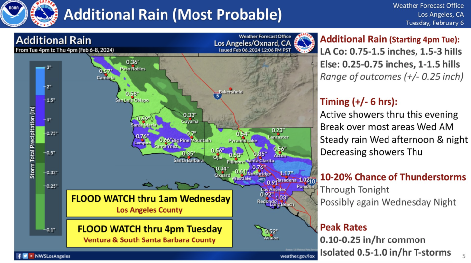
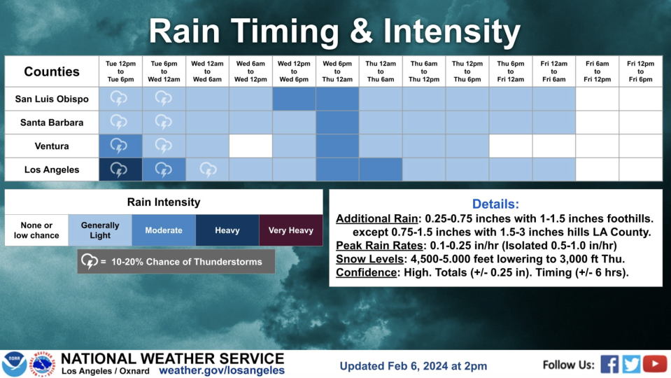
A graphic shared by the NWS shows a predicted .75-1.5 inches of additional rainfall in L.A. County between 4 p.m. Tuesday and Thursday at 4 p.m. Downtown L.A. is expected to see just under an inch, while Pasadena should see another 1.17 inches. Bear in mind that the highest storm total this morning was tallied at the Cogswell Dam, in the mountains above Pasadena. NWS monitors at that site recorded 13.15 inches over the past three days.
The local forecast discussion this afternoon indicated “showers and isolated thunderstorms into the evening hours [tonight]…should end rather quickly by around midnight as the flow turns west to northwesterly. This means Los Angeles and Ventura Counties are in line for a break from the rain during the day on Wednesday.”
Projections see a trough of low pressure “zipping down the west coast and through Southern California on Thursday. This system will be able to interact with the lingering moisture from our current storm to bring one last band of organized precipitation Wednesday afternoon and night. All areas should see about a 3 hour period of steady rain and mountain snow.”
Additionally, “Gusty west to northwest winds will form Wednesday and continue into Thursday. Show levels will lower each day with mountain snow issues increasing. Saturday through at least Tuesday will be dry and warmer.”
There could also be some lingering pockets of precipitation through early Friday. See chart below.
Evacuation warnings and orders were slowly lifted today as rain from the multiple-day storm slowly began to ease, but residents were still urged to remain prepared in case the threats of mudslides, flooding and/or debris flows return.
Residents in the La Tuna Canyon area had been under an evacuation order since the storm began, but the order was lifted late Tuesday afternoon.
Evacuation orders that had been issued for the Agua Fire burn area along Soledad Canyon Road east of Agua Dulce Canyon Road and the Owen Fire burn area, on Santa Maria Road north of Topanga Canyon in the Topanga area, were both reduced Tuesday afternoon to evacuation warnings, although residents were still urged to be prepared to leave if needed.
Culver City on Monday issued evacuation warnings for various streets in the Upper Crest area due to concerns about possible mud or debris flows. City officials said the warnings will be in effect until 11:59 p.m. Tuesday.
In the Hollywood Hills, which has been hardest hit, cleanup, assessment and warnings remain. A mudslide severely damaged six homes and threatened a seventh along Beverly Drive in the Beverly Crest area. Los Angeles Fire Department crews escorted 15 residents out of the area, including nine children, but no injuries were reported. City Building and Safety crews are assessing the extent of damage to the homes.
The L.A. City Storm Impacts site showed the area should still be approached with caution, and roads through Benedict and Brown Canyons remain closed. A section of Mulholland near Fryman Canyon Park was also closed.

L.A. will finally get a substantial break thereafter, though the NWS notes, “Extended projections continue to show a chance for another storm system for the end of next week with a wide range of outcomes.” Stay tuned.
PREVIOUSLY, 9:45 AM: The state of emergency continues in Los Angeles as nearly a foot of rain has fallen in some areas during the past two days. And the relentless atmospheric river event is not over yet.
“This has truly been a historic storm for Los Angeles,” Dr. Ariel Cohen of the National Weather Service said during a news conference this morning. “We’re talking about the third-wettest two day stretch since records started in the 1870s, and we’ve endured this and come through with no fatalities.”
The only higher two-day rain totals in L.A. were in 1934 and 1956.
He added: “We still have light to moderate rain ongoing across the Greater L.A. area, and because the soils are so saturated — supersaturated, in fact… it will take very little additional to increase already-flooded areas with more flooding, landslides, mudslides and other debris flows. Everyone needs to be at a high state of readiness.”
Cohen also said more rain is headed to L.A.
“Over the next several hours we’ll have waves of this activity continue all the way through the mid- to late-afternoon hours. Could have some even heavier downpours come through this after … that could really bring about an increased risk for flash flooding and additional landslides. Do not let your guard down.”
Los Angeles Fire Department Chief Kristin Crowley said that, as of Monday afternoon, the LAFD had responded to 307 reports of mudslides related to the storm.
Pacific Coast Highway at the Los Angeles County and Ventura County border was closed on the northbound side because of flooding.
Falling trees also have menaced the region. A large eucalyptus tree fell onto a house and some power lines in the ritzy Brentwood area early Tuesday, resulting in an outage. Several power poles were damaged, but no injuries were reported.
The Los Angeles Department of Water and Power reported about 7,000 customers were without power as of 9 a.m. Tuesday, with the most impacted areas including Koreatown, Mid-Wilshire, Pacific Palisades and, as mentioned, Brentwood.
There was no immediate estimate on when all power would be restored. DWP officials said additional crews came aboard at 6:30 a.m. to relieve others who have “been working up to 16-hour shifts.”
NWS updated its rainfall totals at noon on Tuesday, and there are some eye-popping numbers. The tony enclave on Bel-Air, home to so many celebrities and wealthy Angelenos, topped a foot of rain, clocking in at 12.32 inches. Many of the most-drenched areas are in the San Fernando Valley:
Sepulveda Canyon at Mulholland: 12.01
Topanga Fire Station: 11.95
Woodland Hills: 11.70
The highest total came at the Cogswell Dam above Pasadena. NWS monitors at that site recorded 13.15 inches of rain in the past 72 hours.
A little farther south, Beverly Hills has seen 8.61 inches of rainfall, Culver City 7.71 inches and Downtown L.A. to the east has endured 8.13 inches.
That means that in just three days, downtown Los Angeles has received more than half of its 30-year average seasonal rainfall, which is 14.25 inches.
Evacuation warnings were issued overnight for areas of Culver City adjacent to significant slopes. The warning applies to areas in the Upper Crest in the hills just east of Overland Avenue, north of the Westfield Culver City mall and about two miles south from the Sony Pictures lot. Officials are warning of possible debris or mudflows there.
“The City is asking residents who live above, below, or adjacent to a hillside in or below the Upper Crest neighborhood” to “prepare to leave your home and the area, gather your family, pets, basic needs and important paperwork and listen for instructions from local officials,” according to an official statement, which also gives a list of streets impacted.
Per Culver City’s Twitter/X account, “Mud flows have been reported behind 2 homes along Cranks Road and 1 along Flaxton Street.”
It still was raining in Culver City at 10:15 a.m.
In the Hollywood Hills, a mudslide severely damaged six homes and threatened a seventh along Beverly Drive in the Beverly Crest area. Los Angeles Fire Department crews escorted 15 residents out of the area, including nine children, but no injuries were reported. City Building and Safety crews were assessing the extent of damage to the homes.
Elsewhere, flash-flood warnings warnings were extended Tuesday for a swath running from Glendale to Santa Clarita to Calabasas and another wide, narrow band along slopes from Newbury Park, through Malibu and Topanga to Bel-Air and West Hollywood.
Flash Flood Warning continues for Santa Monica CA, West Hollywood CA and Beverly Hills CA until 10:00 AM PST pic.twitter.com/mTKOaG49qE
— NWS Los Angeles (@NWSLosAngeles) February 6, 2024
As of 10 a.m., the warnings extended east to Norwalk and Whittier.
Flash Flood Warning continues for Norwalk CA, Whittier CA and South Whittier CA until 12:30 PM PST pic.twitter.com/sCGlBCEoAP
— NWS Los Angeles (@NWSLosAngeles) February 6, 2024
Flash Flood Warning continues for Topanga CA, Lake Sherwood CA and Glenview CA until 9:00 PM PST pic.twitter.com/yrM8LKKBaU
— NWS Los Angeles (@NWSLosAngeles) February 5, 2024
Once the main storm system passes by later tonight, forecasters said a roughly 20% to 40% chance of rain will linger through Friday, although most of that precipitation is expected to be light.
Six Flags Magic Mountain remains closed today due to the storm. Knott’s Berry Farm is also closed, along with the Getty Center and Getty Villa. The Los Angeles Zoo remains closed, as well. Disneyland and Disney California Adventure will both be open until 8 p.m.
On Monday, the Los Angeles Fire Department swift-water rescue made a dramatic save. A man had jumped into the Los Angeles River after his dog fell in. The dog safely swam to shore, but the man had to be plucked from the torrent by a rescuer suspended from a helicopter.
Great work by @LAFD rescuing a man who jumped into the water to rescue his dog, and also safely locating the dog down river.pic.twitter.com/RPpHRuk3DA
— LAPD HQ (@LAPDHQ) February 6, 2024
Farther south in Orange County, Santa Ana City Hall and the Santa Ana Main Library were closed due to a power outage.
PREVIOUSLY, 1:20 PM Monday: The National Weather Service in Los Angeles has extended a flash-flood warning for West Central Los Angeles County and Southeastern Ventura County until 9 p.m. as several local counties remain under a state of emergency. The warning had been set to expire at 6 p.m.
“Doppler radar indicated moderate to heavy rainfall moving into much of the warned area,” read a statement from the NWS. “This additional rain will likely cause additional flash flooding as well as rock and mudslide activity. Recent burn areas could also see debris flow.”
Los Angeles Mayor Karen Bass today signed a declaration of a local emergency that is intended to help the city’s response to the storm and ensure resources for the recovery period. It follows state and county emergency declarations.
“With unprecedented rain came unprecedented preparation, and now comes unprecedented response,” Bass said during a news conference Monday.
Among the late developments is that Disneyland is closing two hours early tonight, at 8 p.m. The resort closed down an hour early on Sunday night — at 10 p.m. rather than 11.
Flash Flood Warning including Glendale CA, Santa Clarita CA and Pasadena CA until 6:00 PM PST pic.twitter.com/PInhQDsdGg
— NWS Los Angeles (@NWSLosAngeles) February 5, 2024
PREVIOUSLY at 12:28 p.m.: Sunday marked one of the wettest days in the recorded history of Los Angeles, according to Mayor Karen Bass, and downtown L.A. set a record for the date, with over 4 inches of rain.
Los Angeles officials urged residents to stay home and off the roads Monday. Gov. Gavin Newsom declared a state of emergency in eight California counties, including Los Angeles and Orange counties. Los Angeles County later declared its own state of emergency.
Local surfer “evacuates” down Sycamore Canyon Creek. #StormWatch #SantaBarbara Video Credit: @surferjock805 pic.twitter.com/N1uoiYSnas
— Ryder Christ (@RyderChristNews) February 5, 2024
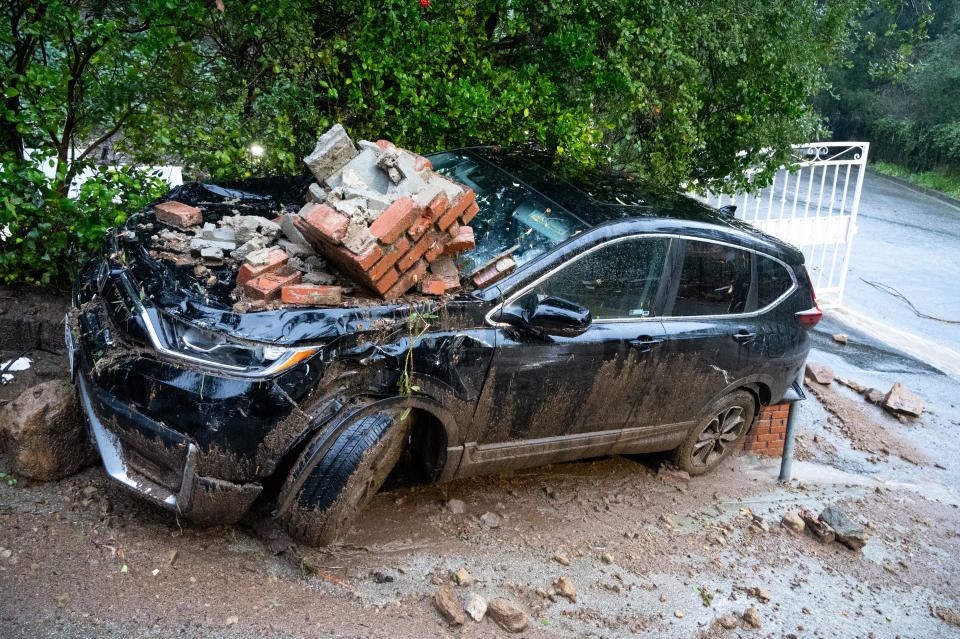
Rocks and boulders fell on parts of Malibu Canyon Road overnight, prompting a closure along that street that later was lifted. LAFD reported that Benedict Canyon and Beverly Glen Canyon roads were closed because of flooding and rock slides.
Video posted online by KNX News reporter Jon Baird shows an SUV buried in mud up to the windows on North Beverly Drive in Beverly Crest.
Another #DebrisFlow in #LosAngeles. This time in #BeverlyCrest. On North Beverly Drive. It looks like one or two cars were practically buried. Authorities say 5 homes sustained significant damage. Firefighters helped people evacuate. 10 people have been displaced. @knxnews pic.twitter.com/2livCNC5Zy
— Jon Baird (@KNXBaird) February 5, 2024
Another post from KCAL’s John Schreiber seemed to show a Beverly Crest-area house that slid off its foundation and down Caribou Lane.
You can see where this house USED to sit before getting knocked completely off its foundation and pushed down Caribou Ln in the #BeverlyCrest neighborhood of Los Angeles. Other homes and at least 3 cars also damaged. @kcalnews #LARain #CAwx pic.twitter.com/9cEjpIlhhe
— John Schreiber (@johnschreiber) February 5, 2024
Topanga was hit even harder, with very close to 11 inches of rain (10.8, per the NWS) falling in the past two days. According to a news conference hosted by L.A. Mayor Karen Bass this morning, a portion of Topanga Canyon Road was closed. Last night, evacuation orders were put in place for a portion of Topanga.

Immediate threat to life. This is a lawful order to leave now. The area is lawfully closed to public access.https://t.co/kLvybm39S8
EVACUATION ORDER ISSUED DUE TO POSSIBLE MUD/DEBRIS FLOWS IN THE AREA OF SANTA MARIA RD. N/O TOPANGA CYN. IN EFFECT THROUGH 6:00PM 2/6/24. pic.twitter.com/4PtY5BuqBy— LASD Lost Hills Stn. (@LHSLASD) February 4, 2024
Another major north-south artery in the Santa Monica Mountains, Malibu Canyon, was shut down at Mullholland and large boulders rained down onto the road.
Drone footage of flooded Malibu Canyon and a bridge to community flooded over on north side of Malibu #atmosphericriver pic.twitter.com/tznytAzXi6
— Reed Timmer, PhD (@ReedTimmerAccu) February 5, 2024
Stretches of nearby Piuma Road were also closed due to flooding and debris flows, with sheriff’s officials reporting several vehicles completely submerged on Piuma.
The Santa Monica-Malibu Unified School District schools were closed Monday.
On piuma about half a mile from the Malibu canyon light/intersections. Around 9 a.m. Monday morning. Take precaution while driving on the canyon. Follow @LHSLASD @CityMalibu @NWSLosAngeles @CaltransDist7 for updates on weather conditions and road closures. Contributed video 🎥 pic.twitter.com/0Hj0EwYQd1
— The Malibu Times (@TheMalibuTimes) February 5, 2024
Two homes sustained significant damage in Studio City when mud and debris slid down a hillside along Lockridge Road. Fire crews evacuated residents from nine homes on the stretch. In the Tarzana/Encino area, three homes were impacted by a debris flow along Boris Drive, prompting the evacuation of 16 residents and nine homes.
Several homes on Lockridge Road in Studio City damaged after part of the hillside came down. Look at the boulders that made their way down the hill to Fryman. @foxla pic.twitter.com/PF92aG1mau
— Gigi Graciette (@GigiGraciette) February 5, 2024
This is just one of a number of places in #LosAngeles where the #storm has caused significant damage. Here, trouble on Lockridge Road thanks to a #debrisFlow in #StudioCity in the #HollywoodHills. @knxnews pic.twitter.com/DGL2UYWs36
— Jon Baird (@KNXBaird) February 5, 2024
With rain expected to continue falling throughout the day and into Tuesday, a flash flood warning was issued until 3 p.m. for the Santa Monica Mountains and the Hollywood Hills.
Flash Flood Warning including Topanga CA, Lake Sherwood CA and Glenview CA until 3:00 PM PST pic.twitter.com/5RcDyzVxY3
— NWS Los Angeles (@NWSLosAngeles) February 5, 2024
“The intensity of the rain will resume,” an official announced at Mayor Bass’ news conference. “Conditions will deteriorate as the afternoon unfolds.”
A flood advisory was issued for the rest of L.A. County through 3 p.m. as rain continued falling. Videos posted online show the region’s waterways – including the L.A. River near Disney and Radford Studios and Ballona Creek near Playa Vista – very close to overtopping bridges and their concrete banks.
#BREAKING #WATCH The #LosAngeles River is very close to overflowing its banks by Coldwater Canyon. #CAwx #AtmosphericRiver #LArain #weather #Flood #Californiastorm #californiaweather #californiaflooding #California #USA
V.C- unstableair pic.twitter.com/CBYlMiM0r3— Elite Theory (@Elite_Theory) February 5, 2024
LA River at Centinela in Playa Vista 😳 pic.twitter.com/Nhsn3qrSex
— Maria Bruggere (@MariaBruggere) February 5, 2024
Roads leading to and through the perennially-flooded Sepulveda Basin were closed, including Burbank Boulevard between the 405 and Balboa Boulevard and Woodley Avenue between Burbank and Victory boulevards.
Residents in the La Tuna Canyon Road area north of Hollywood Burbank Airport were ordered to evacuate until Tuesday due to the high risk of debris flow triggered by the heavy rain.
The affected area borders Horse Haven Street to the north, Martindale Avenue to the east, Penrose Street to the south, and Ledge Avenue to the west, according to the Los Angeles Fire Department.
Eastbound La Tuna Canyon Road was closed to all but residents in the evacuation area at Ledge Avenue, at Sunland Boulevard, at Honolulu Avenue and the westbound lanes are closed at the 210 Freeway with only freeway access allowed.
Six Flags Magic Mountain and Knott’s Berry Farm are closed today. The Getty Center and Villa and The Los Angeles Zoo announced they would also be closed.
“Additional rainfall amounts through Tuesday are generally expected to range from 1 to 2 inches for most coastal and valley areas, with 2 to 4 inches in the foothills and mountains. However, L.A. County will likely see higher amounts through Tuesday with an additional 1.50 to 3 inches for coastal/valley areas, and 3 to 5 inches for foothills and mountains. Rain rates between 0.10 and 0.25 inches per hour will be common through Tuesday, however local rates between 0.50 and 1 inches per hour will occur in heavier showers and thunderstorms.”
According to the National Weather Service, 4.10 inches of rain fell in downtown Los Angeles Sunday, breaking the daily rainfall total for Feb. 4 of 2.55 inches set in 1927. It was the third wettest February day and the 12th wettest day for anytime during the year since 1877, when rainfall totals first started being recorded. The wettest day on record for downtown Los Angeles was 5.88 inches set on March 21, 1938, the year of the city’s great flood.
City News Service contributed to this report.
Best of Deadline
Hollywood & Media Deaths In 2024: Photo Gallery & Obituaries
2024 Premiere Dates For New & Returning Series On Broadcast, Cable & Streaming
'The White Lotus' Season 3: Everything We Know About The Cast, Premiere Date & More
Sign up for Deadline's Newsletter. For the latest news, follow us on Facebook, Twitter, and Instagram.

