Smoke from Western Wildfires Sends Haze Over East Coast as Clouds from Fires Create Own Weather
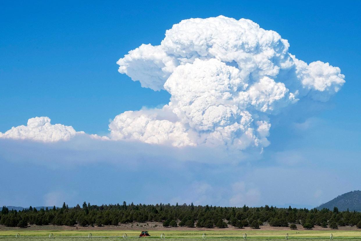
PAYTON BRUNI/AFP via Getty A pyrocumulus cloud from the Bootleg Fire in Oregon
As the Western United States continues to experience dry, hot weather conditions, experts are keeping a watchful eye on the wildfires and their impacts, which are now hitting the East Coast.
On Wednesday, the Dixie Fire broke out in Northern California's Butte County, according to an incident report from CalFire. In just five days, fire officials say the blaze has burned 59,984 total acres and is only 15 percent contained.
Meanwhile, up north in Oregon, the Bootleg Fire has been burning since early July, tearing through 388,359 acres of land with just 30 percent currently contained, per a report from InciWeb. It is the largest fire this year, NBC News reported.
While both fires rage on, scientists have noticed that pyrocumulonimbus clouds have formed in the respective states, bringing with them their own weather, according to the San Francisco Chronicle and the Associated Press.
PAYTON BRUNI/AFP via Getty A pyrocumulus cloud from the Bootleg Fire in Oregon
Pyrocumulus clouds, which are also called "fire clouds," form when the hot, moist air over the fire rises into the atmosphere and condenses into droplets, the AP reported.
They are often found above large columns of smoke near wildfires and look like large, dirty, gray clouds because of the ash and particles that gather inside them, according to the outlet.
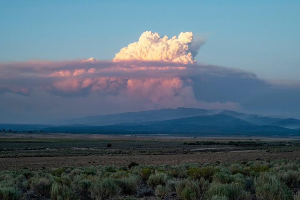
But it's those clouds' big brother, the pyrocumulonimbus cloud, or the "fire-breathing dragon of clouds," that meteorologists are more concerned by due to its ability to generate its own weather, per the AP.
Pyrocumulonimbus clouds form when incredibly hot air and strong winds collide with the moisture in the atmosphere, according to the Chronicle. These clouds have the ability to form a "fire tornado" on the ground by generating their own dry lightning, hail and hot winds, the AP reported.

EPA-EFE/Shutterstock A pyrocumulus cloud billowing from the Bootleg Fire
RELATED: Extreme Heat Wave in Western U.S. to Shatter Records and Affect More Than 40 Million People
According to the Chronicle, they also have "a vacuum effect within wildfires that can kick up erratic, ember-scattering winds, making conditions even more hazardous for firefighters on the ground."
David Peterson, a meteorologist with the Naval Research Laboratory in Monterey, told the Chronicle that the pyro-clouds act "like a giant chimney, taking smoke from the ground and injecting it to the altitude of a jet aircraft."
In California, a pyrocumulonimbus cloud produced by the Dixie Fire shot 31 lightning bolts as firefighters were on the ground on Monday, the Chronicle reported. A massive thunderstorm with rain showers was also reported in the area, per the outlet.
#Dixie wildfire was producing some
pyro cumulonimbus this afternoon within the plume of smoke from between 3:30 pm to present. Currently 4:30 pm. #Cawx pic.twitter.com/ytXYS2eixS— NWS Sacramento (@NWSSacramento) July 19, 2021
RELATED: What to Know About the Deadly Wildfires Ravaging the West Coast - and How You Can Help
Later that day, Robert Baruffaldi, a National Weather Service meteorologist, told the outlet that the 41,000-foot pyro-cloud was reported producing light rain in the area near Lake Almanor.
"At that size, they start generating their own lightning, hail, tornadoes — all the things a normal thunderstorm can create," he explained to the Chronicle. "Some of them get really intense."
A pyrocumulonimbus cloud was also spotted forming near the Bootleg Fire in Oregon last Wednesday, with the National Weather Service calling the formation "extremely dangerous for firefighters."
The #BootlegFire is now producing lightning within its explosive pyrocumulus cloud. As this fire creates its own weather, the volatile nature makes it extremely dangerous for firefighters. Smoke continues to pour into E Oregon & Idaho.#ORwx #IDwx #OregonFires pic.twitter.com/Xew8ixZ2oh
— NWS Boise (@NWSBoise) July 17, 2021
Experts say the fire clouds are becoming more common with the intensity and frequency of the Western U.S.'s wildfires and the impacts of climate change, the AP reported.
The U.S. Naval Research Laboratory also confirmed in a news release Friday that a "record number" of the clouds have been spotted in North America this summer, in areas including Montana and British Columbia, according to the outlet.
"The [Bootleg] fire is so large and generating so much energy and extreme heat that it's changing the weather," Marcus Kauffman, a spokesman for the state forestry department, told the New York Times. "Normally the weather predicts what the fire will do. In this case, the fire is predicting what the weather will do."
It's #TimelapseTuesday, and this imagery from the #GOESEast 🛰️ shows how #wildfire smoke (the grayish-haze compared to the stark white clouds) has been spreading across North America from July 15-19. pic.twitter.com/p2bOMrjNEQ
— NOAA Satellites (@NOAASatellites) July 20, 2021
As firefighters continue to grapple with the clouds while attempting to put out the blazes, the smoke from these fires has reached the East Coast.
In New Hampshire, ABC affiliate WMUR reported that haze from the wildfires had traveled east and was spotted in the state.
Smoke was also visible Tuesday in New York City and Washington, D.C., causing air quality alerts to be issued, NBC News reported.
Given the weather circumstances, officials urged people to stay alert and take caution with the air quality, especially for those in sensitive groups, according to the outlet.
"The smoke will also mean hazy skies & spectacular sunsets for many," the National Weather Service added in a tweet.

