Road to Mount St. Helens observatory closed indefinitely after ‘catastrophic’ landslide
A popular observatory near Mount St. Helens is indefinitely closed as engineers evaluate a massive landslide that blocked State Route 504.
Johnston Ridge Observatory, located within Mount St. Helens National Volcanic Monument, overlooks the north side of the mountain that collapsed in a 1980 eruption.
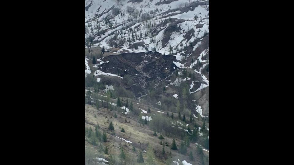
SR 504, which leads to the observatory, closed Sunday evening due to a debris slide that covered the upper portion of the roadway and washed away Spirit Lake Outlet Bridge. A dozen people and a dog had to be evacuated from the observatory by helicopter following the landslide.
It’s unclear when the roadway may reopen again, according to a Tuesday news release from the Washington State Department of Transportation. The debris fell about 2,000 feet from a hillside adjacent to the highway and caused “catastrophic damage” to the 85-foot bridge span, according to WSDOT.
“Additional safety analysis is needed, but due to the ongoing geological instability in the area, it’s too soon to tell when we’ll be able to safely do that work,” said Brad Clark, WSDOT Southwest Region Maintenance Manager. “We appreciate everyone’s patience during this emergency.”
Travelers on SR 504, also known as Spirit Lake Memorial Highway, cannot travel past milepost 43 near the Science and Learning Center at Coldwater. In addition to the observatory, the release says travelers cannot access Coldwater Lake.
The U.S. Forest Service says the following trails are closed as well.
Lakes Trail #211
Coldwater Trail #230
Hummocks Trail #229
Birth of Lake Trail #246
Boundary Trail #1 also is not accessible from Mount St. Helens area.
No detours are available, and the public is strongly advised to avoid the area of the SR 504 closure for “everyone’s safety,” according to the release.
WSDOT is coordinating with the U.S. Forest Service, U.S. Army Corps of Engineers, U.S. Geological Survey and Skamania and Cowlitz counties to evaluate slope conditions. Once that’s done, the release says workers may begin taking steps to stabilize the slope as well as clear and rebuild the roadway and bridge.
Officials have not yet determined the cause of the landslide. However, they suspect the recent heatwave dramatically melted snowpack, oversaturating the soil and overfilling the channels of the slopes. The release says debris likely joined high water, which built up and broke free. This all rolled downstream and washed out the bridge and roadway.
Alerts about closures for the area can be found on the Gifford Pinchot National Forest website.
WSDOT also keeps an updated real-time travel map of all state roads on its website.
Mount St. Helens, located within Gifford Pinchot National Forest, exploded on May 18, 1980, leaving 57 people dead or missing. Two years after the explosion, the federal government established the 110,000-acre National Volcanic Monument for research, recreation and education. About 750,000 people visit the various sites in the monument each year.
Johnston Ridge Observatory sits near the camp site of David Alexander Johnston, a U.S. Geological Survey volcanologist who died in the eruption. It is about 50 miles east of Castle Rock.
The observatory features interpretive displays that show geologic events leading up the eruption, according to the U.S. Forest Service.

