Predicting Earthquakes Anywhere on Earth with GPS

Most of the time we take for granted that the Earth is stable beneath our feet, so the characters of La Brea (streaming now on Peacock) might be forgiven for not being prepared when a sinkhole swallowed them up along with a few blocks of downtown Los Angeles.
As of now, sinkholes, volcanoes, and earthquakes often come with little or no warning, alerting you only when the ground begins moving beneath you. But could that change?
Can earthquakes be detected?
Existing warning systems for earthquakes provide, at best, a few minutes of early warning and that’s only if you’re a ways away from the epicenter. If you happen to be standing over the bullseye, there is no warning for you. But there might be in the future, according to a recent study published in the journal Science.
RELATED: Transforming Yellowstone’s Earthquake Vibrations into Music
Detecting Earthquake Precursors with GPS
Despite the best efforts of scientists all over the world, we haven’t succeeded in finding a reliable alarm bell for a looming earthquake, but that doesn’t mean one doesn’t exist. Researchers suspected that if such a precursor signal did exist, they might be able to find it in the global positioning system (GPS) stations spread along known fault lines.
Those GPS stations collect position data for the land they’re standing on, with an accuracy of a few millimeters, every five minutes. If there is any slippage happening on the fault before the actual quakes strike, it should be revealed in the GPS data. To find out, researchers gathered the GPS data for the 48-hour period leading up to 90 earthquakes with magnitude seven or greater, which occurred over the last 20 years.
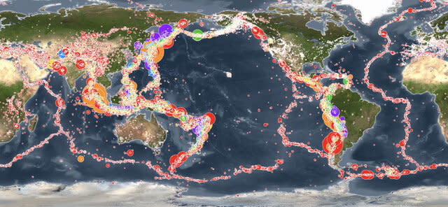
All the recorded earthquakes from Jan. 1, 2001 - Dec. 31, 2015 are shown on this global map. Credit: Pacific Tsunami Warning Center
All told, they gathered more than 3,000 sets of data, spanning the two days leading up to big quakes. Then they stacked all of their 48-hour time series on top of one another to see if anything stood out. Most of the leadup to a quake was uneventful, just featureless data noise, but researchers found a clear signal of increased land movement beginning two hours before a quake. That suggests there is a signal, but we don’t have the resolution to see it in real time.
RELATED: Weird water dynamics fuel deep earthquakes and fist-sized diamonds
The signal stands out in the stacked data only because they’re looking at so many observations all at the same time. It would be like looking for an object that’s not moving in a still photograph. You can’t really tell who or what is standing still in a single snapshot, but if you take a few dozen or a few hundred and stack them together, the things that are moving and the things that aren’t moving become abundantly clear.
Of course, you typically want early warning systems to actually provide early warnings. At present, that isn’t possible even if future research confirms the presence of a precursor signal for earthquakes. It’s always easier to see something in retrospect and it’s unclear if the research will actually translate into a useable system.
There is also some bias in the location of GPS stations. Some faults and some areas are more heavily observed than others. Which means that even if the system worked today, it would provide solid warnings for some places but not for others. More sensitive detectors, and more of them, might go a long way toward making two-hour earthquake warnings a reality.
Catch La Brea, streaming now on Peacock!

