How much snow will New York get Friday and Saturday? See projected inch counts
The National Weather Service issued a winter storm watch for parts of the Hudson Valley for Friday evening through Saturday evening. The watch, which is in effect for Westchester County and New York City, is in anticipation of accumulating snowfall through Saturday. Snow accumulation is expected for the rest of the Hudson Valley including, Rockland, Putnam, Dutchess, Orange, Ulster and Sullivan counties.
AccuWeather senior meteorologist Paul Walker said the first flakes will begin falling in the Hudson Valley region late Friday night, possibly not until after midnight, and continue through the day Saturday and into the evening.
Forecast: Winter storm could bring anywhere from an inch to a foot of snow in Hudson Valley
Are you too old to shovel snow?: If you're over 45, beware of heart attacks, doctor says
Storm prep: 5 essential ways to prepare for a snowstorm
The National Weather Service is still tracking the storm, but it made initial calls Wednesday evening.
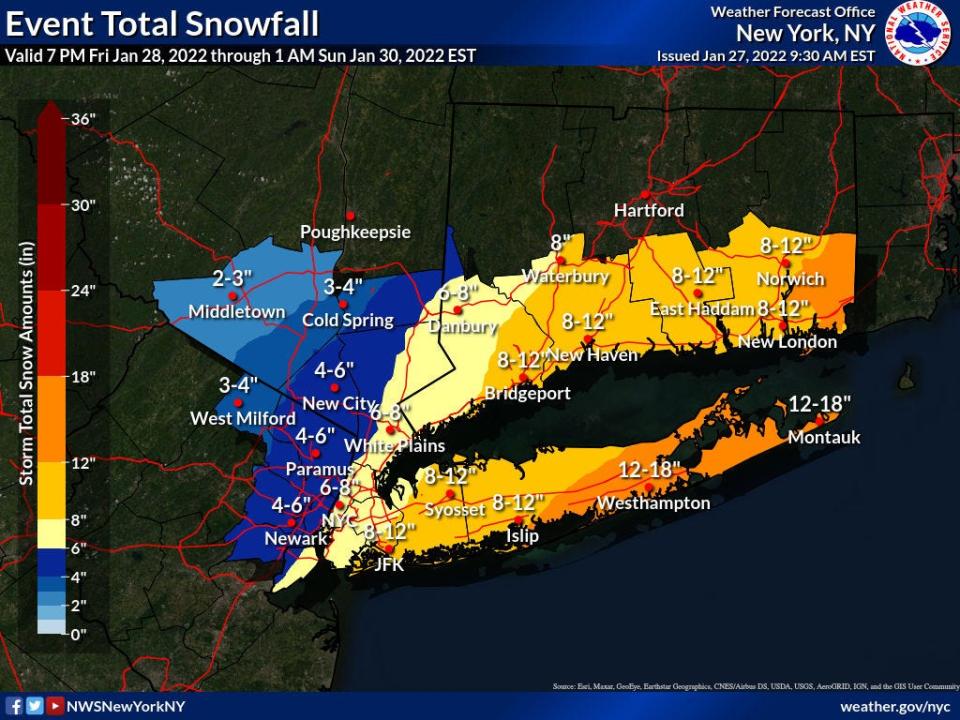
How much snow is expected?
Here's what the National Weather Service is calling for Friday and Saturday as of Thursday morning:
Westchester County
White Plains: 8-12 inches
Rockland County
New City: 6-8 inches
Orange County
Middletown: 3-4 inches
Port Jervis: 3-4 inches
Dutchess County
Poughkeepsie: 4-6 inches
Putnam County
Cold Spring: 4-6 inches
Ulster
Kingston: 3 inches
Sundown: 2-3 inches
Sullivan County
Monticello: 1-2 inches
This article originally appeared on Rockland/Westchester Journal News: New York snowfall forecast: How much snow will Hudson Valley get?

