This Magical Floating Tent Will Make The World Your Waterbed

Campers, rejoice! This floating tent is all you need for a night on the water.
Fly fishing outfitter Smithfly is debuting a product they call the Shoal Tent, which they say will turn any pond, creek or salt flat into your personal waterbed. The floating raft fits two people comfortably underneath an inflatable tent topper, with none of those pesky poles (the company says its three air chambers can stand up to high winds on their own). The floor is a 6-inch-thick air mattress of sorts, which lets you relax smack dab in the middle of nature.
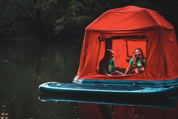

Camping retailers offer hammock tents aplenty, but floating abodes are harder to come by. This looks like the sturdiest and roomiest we’ve seen on the market yet.
The product description makes no mention of anchors, so we imagine you’d need to set up camp in a calm, current-free body of water in order to avoid a splashy “Parent Trap” moment.
Shoal Tent comes at a cost, however. It currently retails for $1,499 on Smithfly’s site, where you can pre-order it for shipping in late December or early January.
Also on HuffPost
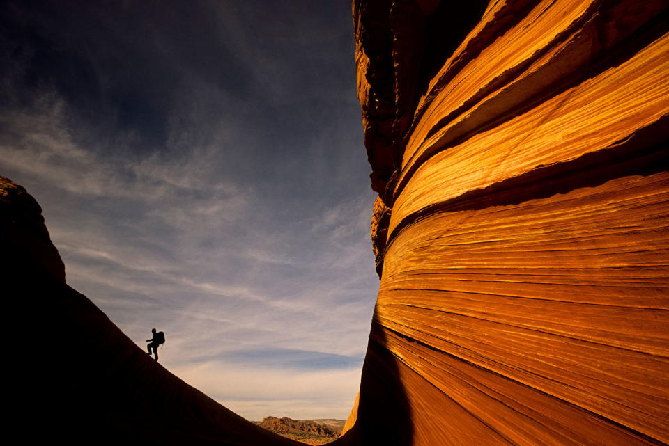
The Wave, Paria Canyon, Arizona-Utah
Wow Factor: Find the most unique and lovely feature carved into red sandstone desert canyons.
Do It: The sandstone formations and erosion-carved slot canyons of the Colorado Plateau are so stunning and varied, it’s hard to choose just one as the most photogenic. But the Wave, deep within the canyons of the Paria Canyon/Vermilion Cliffs Wilderness on the Arizona/Utah border, may just be the weirdest and most wonderful result of what ancient, uplifted red rock and eons of wind and water can create. Rain and flash floods began sculpting the Wave, exposing different grain layers of Jurassic-era sandstone in the canyon over millennia. Then wind finished the job, smoothing out a unique piece of natural art: a canyon that captures the undulating movement of water and wind over the rock. It’s also an accomplishment to get here—the easiest hike via Wire Pass Wash rambles through unforgiving sandstone desert, and there is no maintained trail to the Wave itself, so finding it requires GPS skills.
Don’t: Hike to the Wave without a permit. Part of the beauty of the place is that the crowds are limited thanks to a 20-person-a-day limit in the Coyote Buttes North Area.
Tire-Bouchon Pass, Taghia, Morocco

Wow Factor: Trek into one of the hardest spots to reach in North Africa.
Do It: The region around the Moroccan village of Taghia is the place to go if you want to get remote. It’s cut off from the rest of the world because it has no roads, and the Berber people here continue to live as they have for generations. It’s also a rock climber’s paradise that has attracted big names in the sport—including free-solo artist Alex Honnold and photographer and guide Kristoffer Erickson—to its soaring limestone walls. High in the Atlas Mountains, Taghia’s roughly 150 residents live at a relaxed pace (they only recently got on the electrical grid), despite the trickle of climbers who come here to escape the usual well-known crags and big walls. Erickson and his wife have built a house here and founded the Atlas Cultural Foundation to help support the local people, especially underserved women and children. You don’t need to be a top alpinist to enjoy the place, however: The most daring hike might be up the Tire-Bouchon Pass, which requires contorting up and down a dry waterfall choked with dead wood to reach the plateau of Tagoujimt n’Tsouiannt.
Don’t: Visit in winter when the mountains are coated in snow and Taghia is shadowed by the towering cliffs. During this season, the village receives less than an hour of sun during the day.
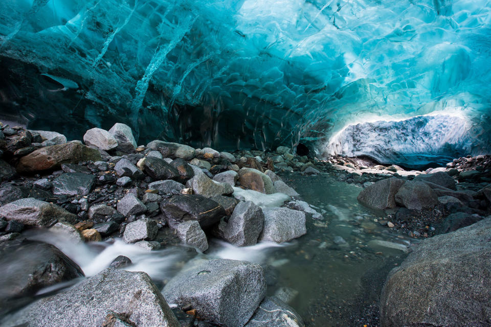
Mendenhall Ice Cave, Juneau, Alaska
Wow Factor: Hike underneath a glacier.
Do It: While the Mendenhall Ice Caves are just 12 miles (19.3 kilometers) from downtown Juneau, they are not particularly easy to reach. It requires either a paddle on a glacial lake and/or a hike down an unmarked trail and over the ice of the Mendenhall Glacier. The effort to reach this ever shifting fantasyland is well worth it: In the blue light of the caves, hikers wander underneath the melting terminus of the glacier. It’s a rare natural space, melting and changing and in danger of disappearing completely as the Mendenhall Glacier continues to recede—it is 2.5 miles (four kilometers) farther up the valley than it was in the mid-1700s, and soon it may no longer connect to the waters of Mendenhall Lake. For now, however, the most photographed ice cave gives those who can reach it a look into just what happens in the terminus of this moving sheet of ice. Weird formations and drips of water carve out a transitory place that few humans ever see.
Don’t: Visit without an ice axe, crampons, and glacier travel knowledge. The glacier is always changing and always dangerous, with crevasses that could trap unwitting, unprepared hikers.
Boiling Lake, Morne Trois Pitons National Park, Dominica

Wow Factor: Peer into the bubbling cauldron of one of the largest hot springs on the planet.
Do It: Volcanic forces are still busy at work forming Dominica, the northernmost of the Windward Islands, and unlike so many Caribbean Edens, the island is not overrun by bland package tourism. Lush rain forest and steaming fumaroles cover the flanks of the active Morne Trois Pitons volcano. Here Boiling Lake, 200 feet (61 meters) wide, bubbles and steams in a volcanic cleft. The hike in to view the second largest boiling lake on Earth—the water temperature has been measured at just under 212°F (100°C )—from the rocky outcrop above rambles through rough terrain, dipping down to river valleys in the cloud forest before breaking into volcanic plains covered in lichen and moss. But the main attraction is the lake itself, which has been left in its wild state, unencumbered by railings and interpretive claptrap. The temperature of the lake can change, however, and in recent years it has been nothing but steaming mud or just tepid water.
Don’t: Jump in. Even though the lake has cooled enough that foolish souls have bathed in the waters, you will cook. Instead, cool yourself off in the Titou Gorge at the end of the hike.
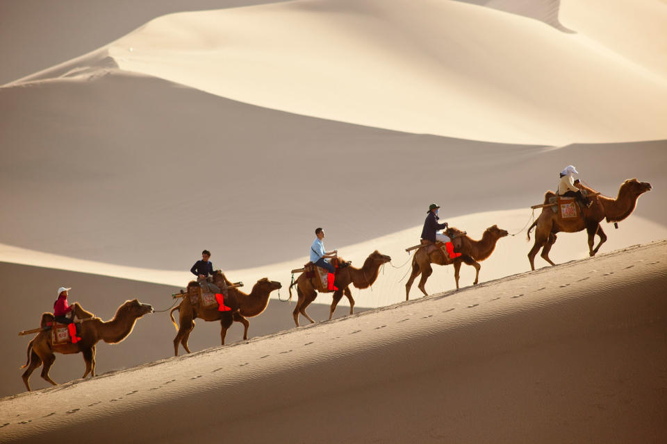
Mingsha Sand Dunes, Dunhuang, China
Wow Factor: Hear the music of the desert.
Do It: The sands of the 203-square-mile (526-square-kilometer) Taklimakan Shamo continue to expand and build into megadunes near the ancient outpost city of Dunhuang. The most impressive of these sand mountains is Mingsha, also known as the singing sand dune or echoing sand dune because the grains blowing over the top of the dune make an eerie music, which gets even louder if you slide down the dune’s sides. The height of the highest dune here is ever changing but usually towers about 820 feet (249.9 meters) above the town, looking like a massive wave about to roll in and break over it. Many trek up the dunes on two-humped Bactrian camels, but it’s a more intimate experience to hike it and hear the music of the desert wind—and then play on the way down (local outfitters even provide sleds). At the base of the dune lies Crescent Lake, a spring-fed oasis that has escaped the blowing sand in a wind-protected depression. It can bustle with tourists, however.
Don’t: Forget extra water.
Isla del Sol Traverse, Bolivia
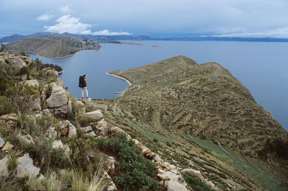
Wow Factor: Check out sweeping views of the Andes from a lonely island in the middle of the highest navigable lake on Earth.
Do It: According to myth, Lake Titicaca is where the Inca god Viracocha rose from the waters after a massive flood and began to create light, the world, and the first humans. That feels entirely plausible from the shores of Isla del Sol, the roadless island in the midst of the southern end of the lake’s expansive blue. The island can be reached only by ferry, and there are no roads or cars here, just dirt tracks and well-maintained trails that the island’s 800 inhabitants use to travel across Isla del Sol and reach its tiered agricultural system. While the tourist trade here can be intense, it’s worth it to hike the place where the sun supposedly hid during the legendary flood, walk through ruins and down steps that once led to a city that predated the Inca, and gaze across the deep blue of this lake at the roof of a continent. Finish off the walk with a quick dip in the lake.
Don’t: Forget to acclimatize. Lake Titicaca sits at 12,507 feet (3,812 meters).
Trift Bridge, Gadmen, Switzerland
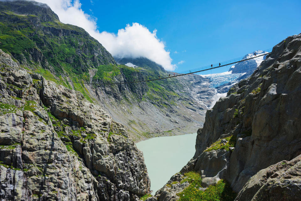
Wow Factor: Stare into a receding glacier and hang above the abyss on the longest suspension bridge in the Alps.
Do It: The Trift Bridge is almost as much of an extreme amusement park ride as it is a hike. This Swiss engineering marvel stretches for 558 feet (170 meters) and hangs 300 feet (91.4 meters) above Triftsee, a milky blue lake. If you can calm your nerves enough and look around while shifting with the breeze and each careful footstep in the middle of the bridge, you can gaze into the heart of the Trift Glacier, which is receding rapidly due to a warming climate. In fact, the harrowing Trift Bridge was first built in 2004 to reach the Trift mountain hut, since the glacier is melting so rapidly that hikers can no longer travel across its tongue.
Don’t: Even think about crossing this span if you get vertigo. Ironically, the current, stronger version of the Trift Bridge was built in 2009 to replace the rickety 2004 bridge.
Half Dome, Yosemite National Park, California
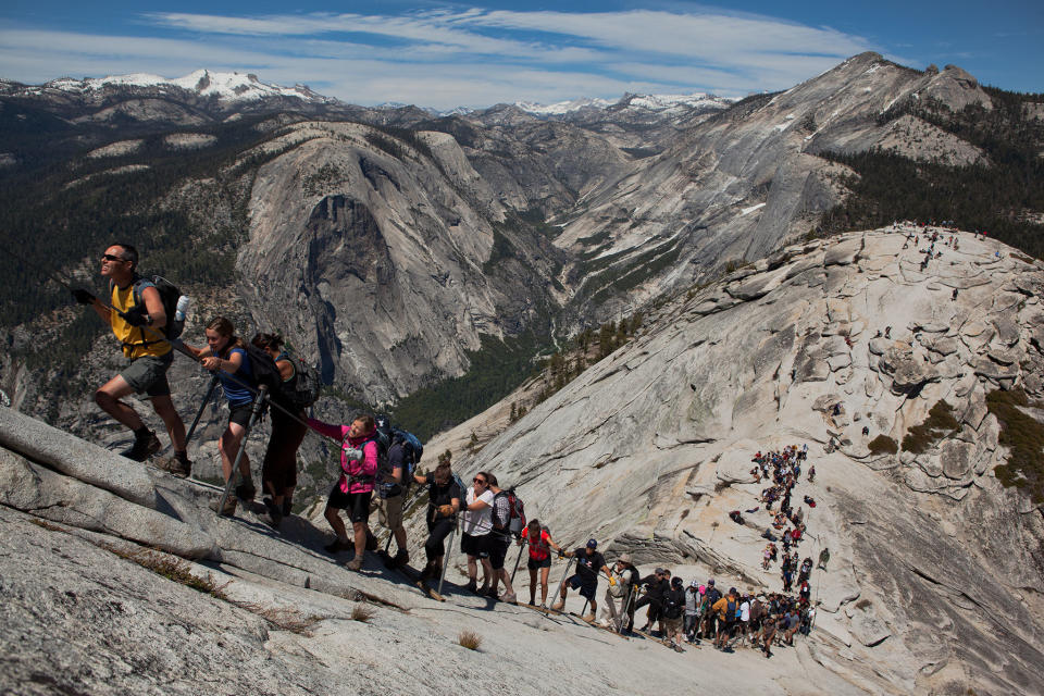
Wow Factor: Hang on for dear life to "hike" to the top of a big-wall climbing objective.
Do It: While Yosemite’s Half Dome may be one of the most important targets for big-wall rock climbers on the planet, it’s also possible to hike to the summit—sort of. The famed 400-foot (121.9-meter) cable route leads those without the skills to climb up the massive chunk of granite that rises 5,000 feet (1,524 meters) above the valley floor, but it’s one harrowing ascent. Hikers hold on to the two cables for dear life with the void looming below. OK, it’s not that bad, and according to the National Park Service, “since 1919, relatively few people have fallen and died on the cables.” The danger certainly does not stop thousands of visitors from heading up the route each year. Don’t discount the rest of the hike, either. It’s a big, long slog up 4,800 vertical feet (1,463 meters) in some of the park’s deepest wilderness just to reach the cables.
Don’t: Head up the cables when bad weather is looming. The route is as exposed as it gets and can be deadly in lightning storms or when the rock is wet.
Caves and Broken Top Loop Trails, Craters of the Moon National Monument, Idaho
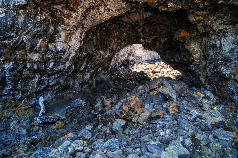
Wow Factor: Scramble through lava tubes and around volcanic formations in one of the most inhospitable landscapes in the American West.
Do It: Unlike classic stratovolcanoes, the lava rock fields and weird formations of Craters of the Moon formed when a rift tore open the earth: Magma oozed and erupted up in massive flows on the flat grasslands of the Snake River Plain. At the time, the Yellowstone hot spot—the massive, active volcanic caldera that makes up most of Yellowstone National Park—sat under this part of Idaho, and lava poured up from massive cracks, cooling into the same aa and pahoehoe rock being formed as lava cools in Hawaii today. The result is one of the most hostile playgrounds on the planet, a 400-square-mile (643.7-square-kilometer) labyrinth of cooled lava turned into tunnels and caves and rock that rips apart hiking boots. These two short hikes from the visitors center take you deep enough into this blasted, oddly beautiful wasteland of cinder cones and caves, some with year-round ice (permits are required to enter the caves).
Don’t: Wander too far off the trail. The lava formations create a maze that seems innocent from the outside but can be impossible to trace your way out of later. In 2013, two women who wandered off-trail here perished in the lava.
Mount Bromo, Bromo-Tengger-Semeru National Park, East Java, Indonesia
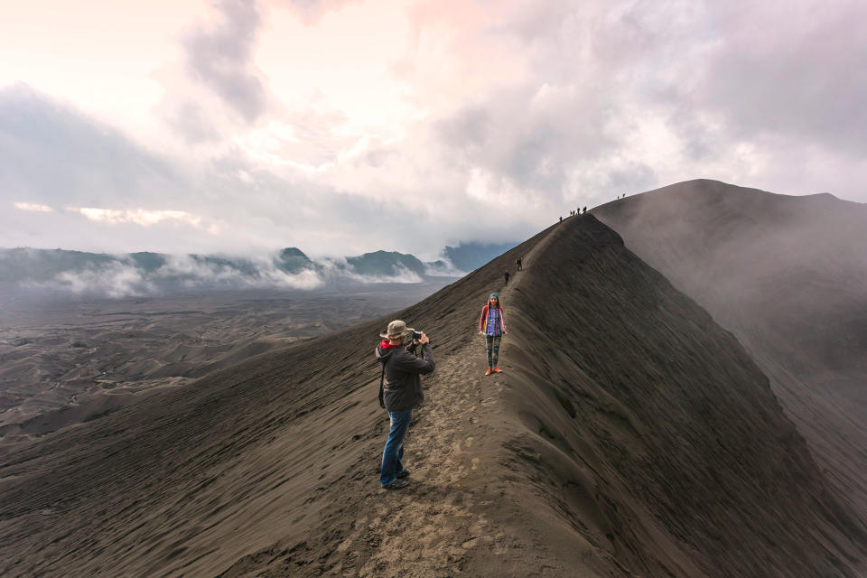
Wow Factor: Climb to the rim of an active volcano.
Do It: A perfect crater belching sulfurous steam, 7,641-foot (2,329-meter) Mount Bromo rises along with five other volcanoes from a flat sea of sand inside the massive Tengger caldera. Hiking to the rim of this moody giant (it is still quite active, as are many of the surrounding volcanoes) puts you in the midst of a primeval landscape, with the perfect cone of nearby 12,060-foot (3,675.9-meter) Mount Semeru simmering on the horizon. While the final climb up the sides of the volcano may be tough, the real trudge is through the laut pasir, the undulating sea of volcanic sand and ash that fills most of the larger caldera. It’s not all desolation, however; the sea of sand also houses the Pura Luhur Poten temple, built out of black stone by the native Tenggerese people, a pocket Hindu population in the largest Muslim country in the world. On August 14, the Tenggerese gather here and then toss offerings into Mount Bromo’s crater. A full tour includes a sunrise hike up Mount Penanjakan, which offers sweeping views of the caldera, and up the cone of dormant, 8,005-foot (2,439.9-meter) Mount Batok.
Don’t: Go without checking with Bromo-Tengger-Semeru National Park for conditions. Mount Bromo erupted as recently as 2011, and more activity in 2015 closed the trails.
Love HuffPost? Become a founding member of HuffPost Plus today.
This article originally appeared on HuffPost.

