Magic Mountain Closes As Snow Begins To Fall North Of Los Angeles; Disneyland, Universal Studios Hollywood Staying Open
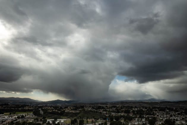
Six Flags Magic Mountain in Santa Clarita north of Los Angeles closed today due to “inclement weather,” according to a park statement. Local station KTLA reported its radar showed, “lower level snow in areas of Simi Valley, Santa Clarita, La Crecenta and La Cañada Flintridge” at about 5 a.m. this morning.
Radar indicates lower elevation snow in areas of Simi Valley, Santa Clarita, La Crescenta and La Cañada Flintridge this morning. Track your phone, tablet or PC: https://t.co/kR2JMdLfe9 pic.twitter.com/wPWvdzGez5
More from Deadline
— KTLA (@KTLA) February 23, 2023
It’s not just snow and/or rain park officials have to consider. Wind is a major point of concern with the incoming storm, especially given the height of some of the park’s attractions.
Magic Mountain sits at about 1,150 feet above sea level. Its Goliath roller coaster, for example, climbs 235 feet in the air, and with winds there at 37 mph, per the National Weather Service, and 70 mph at nearby (but much higher) Magic Mountain Truck Trail, one gets the sense of how added elevation increases wind velocity in the region.
Visit https://t.co/AhG51cHMRa for additional park hours. pic.twitter.com/ObBGnlwkxh
— Six Flags Magic Mountain (@SFMagicMountain) February 23, 2023
The park’s web site indicates that it will be open tomorrow and Saturday but, given that the storm’s impacts are expected to worsen in the next 36 hours, it’s likely that status will change. In fact, a Euro Model cited by another local outlet, CBS Los Angeles, shows over a foot of snow falling in the next 36-48 hours.
Hollywood sign powder run? pic.twitter.com/zV2cluoFC9
— Skip M (@vespadodger) February 23, 2023
Other parks in the region remain open. Universal Studios Hollywood, which sits at just over 700 feet, has no plans to close, Deadline hears. Ditto Disneyland in Anaheim.
Disney’s parks unit, of course, has extensive experience with modifying operations due to inclement weather and even caring for guests during hurricanes. Disneyland Resort officials adjust outdoor park offerings — like shows and parades — in both Disneyland California Adventure if weather becomes untenable. Those decisions are usually left until very close to showtime. As of this morning, all the parks’ offerings were a go. If inclement weather causes a parade to be canceled, there is typically a rainy day cavalcade of characters to take its place.
By mid-morning Thursday, hail had been reported in locations including Pasadena and Long Beach, while light rain fell in many other areas, leading to a damp but manageable morning commute. Forecasters warned that unusually low snow levels could endanger motorists on mountain passes by later in the day. In fact, chains were already being required in parts of La Cañada Flintridge.
“For today (Thursday) and tonight just scattered light showers with rates generally a tenth of an inch per hour or less,” read a statement from the National Weather Service.” More shower activity than yesterday but still mostly on the light side. Main thing today continues to be the low snow levels which will result in some impacts to roads through the mountains, even in areas that don’t often get snow, such as Cuesta Pass in (San Luis Obispo), possibly San Marcos Pass above Santa Barbara, and Highway 14 between Santa Clarita and the Antelope Valley.” CalTrans was already putting sand on the 14 in hopes of breaking down ice and snow more quickly.
Santa Barbara? Is that you? A blizzard warning goes into effect in SB County mountains tomorrow morning. This is from our live camera this morning. #castorm #snow #SantaBarbara #weather #ice pic.twitter.com/JsiQZPNJvC
— Alys Martinez (@AlysMartinezTV) February 23, 2023
Forecasters said the snow level will drop as low as 1,500 feet Thursday, but it will increase to at least 2,000 feet by late Friday morning.
The winter storm is expected to intensify by late Thursday and into Friday. The NWS issued a rare blizzard warning that will be in effect for the Los Angeles County mountains from 4 a.m. Friday to 4 p.m. Saturday. Forecasters said up to 5 feet of snow could accumulate in the mountains above 4,000 feet, accompanied by wind gusts topping 80 mph that will create “near zero visibility.” Higher elevations could see as much as 8 feet of snow, with accumulations of 6 to 12 inches possible at elevations between 2,000 and 4,000
feet, “including most major mountain passes.”
According to the NWS Los Angeles office, the blizzard warning is the first issued in the area since 1989, when a warning was also issued for the L.A. County mountains.
Ahead of that, a winter storm warning will be in effect in the mountains until 4 a.m. Friday for the mountains, thanks to anticipated “low elevation snow, strong winds and very cold wind chills.” In the Antelope Valley, a winter weather advisory will be in effect until 10 a.m. Friday, with forecasters anticipating 3 to 6 inches of snow in the foothills and 1 to 3 inches on the valley floor, with winds gusting to 45 mph.
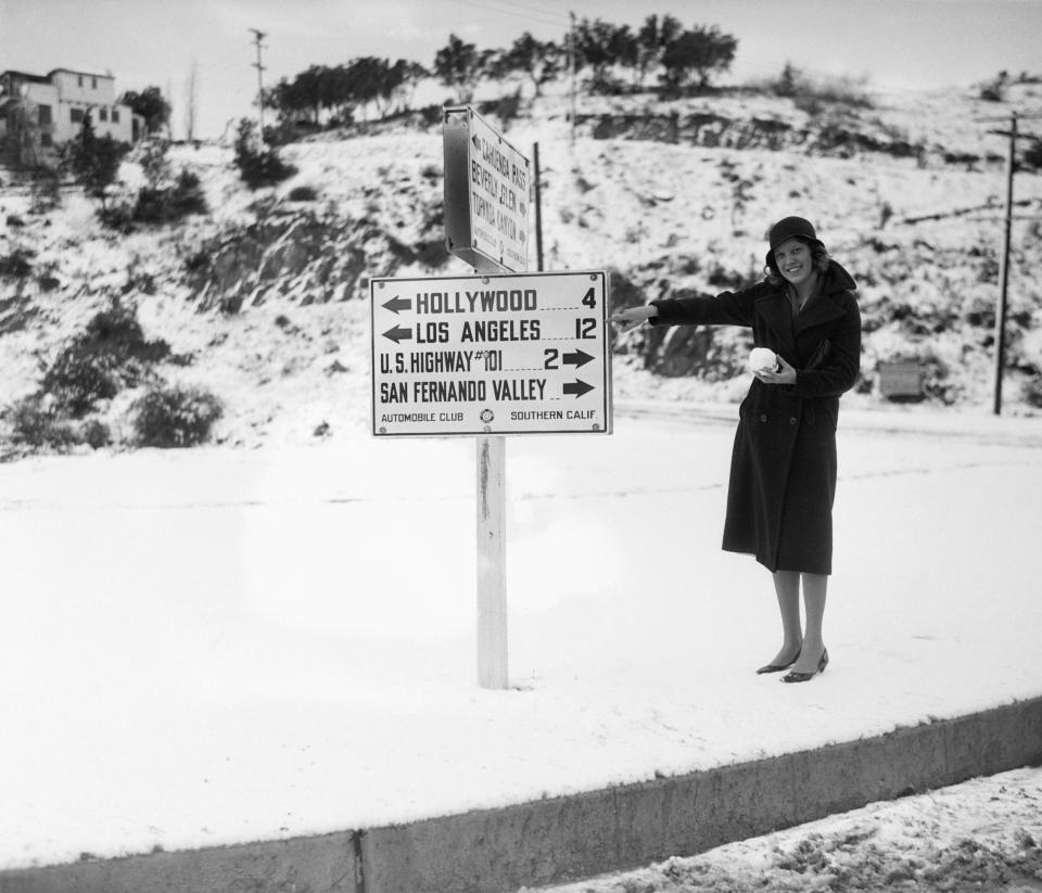
Forecasters said temperatures will remain chilly Thursday, with coastal and valley areas hovering in the 40s and 50s. The snow level could fall as low as 1,500 feet in the foothills, with the possibility of accumulating snow on the Grapevine section of the Golden State (5) Freeway. For reference, the Hollywood Sign sits about about 1,600 feet. Snow fell nearby back in 1939.
When the brunt of the storm begins to arrive Thursday, all major mountain passes will be at risk of snow, while other areas could get up to a half-inch of rain.
By Thursday night, however, things will begin to worsen.
“This system will bring a broad swath of moderate to locally heavy rain and snow (to) the area,” according to the NWS. “Snow levels will fluctuate quite a bit as the southerly flow will raise levels to about 4,500 feet briefly on Friday afternoon. This could create a mixture of rain/snow at the I-5 Grapevine area before precipitation turns back to all snow Friday evening.”
Coastal and valley areas could get between 2 and 5 inches of rain during the storm by Saturday night, with 5 to 7 inches possible in the foothills.
“Flooding of small streams and urban areas will be possible with these amounts and a few main stem rivers may overflow their banks,” according to the NWS. “Peak rainfall rates will generally be 0.25 to 0.75 inches per hour, but locally around an inch in thunderstorms and foothills to lower mountain slopes, where it is not snowing. These rates are capable of creating shallow mud and debris flows in and below recent burn scars.”
A flood watch will be in effect from Friday morning through Saturday afternoon for Los Angeles County beaches, the coastal region including downtown, the L.A. County mountains, Santa Monica Mountains and the San Fernando, Santa Clarita and San Gabriel valleys.
A flood watch will also be in effect in Orange County, covering inland areas and the Santa Ana Mountains and foothills.
But snow will be the bigger story of the storm, with the low elevation snow level contributing to what could be “the largest amount of 24-48 hour snowfall seen in decades, likely rivaling the 1989 storm, for our Ventura and Los Angeles County mountains,” according to the NWS.
“Snowfall of this rate and amount could lead to damage to structures and trees with an immense threat of avalanches, especially in the eastern San Gabriel Mountains by Saturday,” forecasters warned.
Temperatures will be in the 40s and 50s in most of the area, although they will drop into the 30s in the mountains and some valley areas, particularly at night, and into the 20s in the Antelope Valley.
High winds will make it feel even colder. Forecasters said strong winds will impact the entire region Friday and Friday night, strongest in the mountains and deserts. Gusts of 55 to 75 mph are anticipated in those areas, contributing to the blizzard-like conditions.
“Winds may drop off Saturday, so the Blizzard Warning may be downgraded early for some areas,” according to a NWS forecast. “Expect whiteout conditions at times within the Blizzard Warning, mainly above 3,500 to 4,500 feet in elevation. Significant blowing and drifting of snow combined with the whiteout conditions will make driving very difficult to impossible, including for rescue crews.
“The incredible amount of snow combined with the strong wind will lead to extreme avalanche conditions along steeper terrain and at lower elevations than we typically experience in southern California. The most significant threat for avalanches is typically within 24 hours of new snowfall. The heavy snowfall will increase risk of downed trees and power outages and can cause damage to roofs which have shallow slopes.”
City News Service, contributed to this report.
Best of Deadline
Sign up for Deadline's Newsletter. For the latest news, follow us on Facebook, Twitter, and Instagram.

