LIVE UPDATES: Hurricane conditions from Ian expected Wednesday morning in Manatee County
Find the latest live updates for Wednesday here.
Mandatory evacuations have been extended in Manatee County and now include Zones A and B — which includes about 120,000 households — as Hurricane Ian is expected to make landfall near Venice in Sarasota County.
Voluntary and highly recommended evacuation order was also issued for Zone C.
The orders were announced on social media just after 9 a.m. Tuesday after the forecast track shifted the storm east.
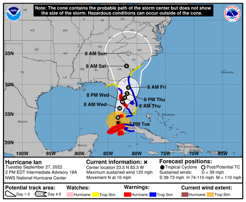
Hurricane Ian reemerged from Cuba as a Category 3 storm with 120 mile per hour winds and is regrouping over the Gulf of Mexico.
Here’s the latest forecast update.
Forecast update
Hurricane Ian’s potential landfall point continued to shift south with an 11 p.m. update from the National Hurricane Center.
The storm is still predicted to approach the west coast of Florida on Wednesday as a major hurricane — likely a Category 4 storm — but the center of the storm is now forecast to strike in the Charlotte Harbor area, south of Port Charlotte and north of Fort Myers.
A tropical storm watch north of Altamaha Sound to South Santee River is upgraded to a tropical storm warning; otherwise, no changes to the Gulf Coast’s watches and warnings were made.
Storm surge estimates for Bonita Beach to Chokoloskee also increased slightly, from 6 to 9 feet to 6 to 10 feet.
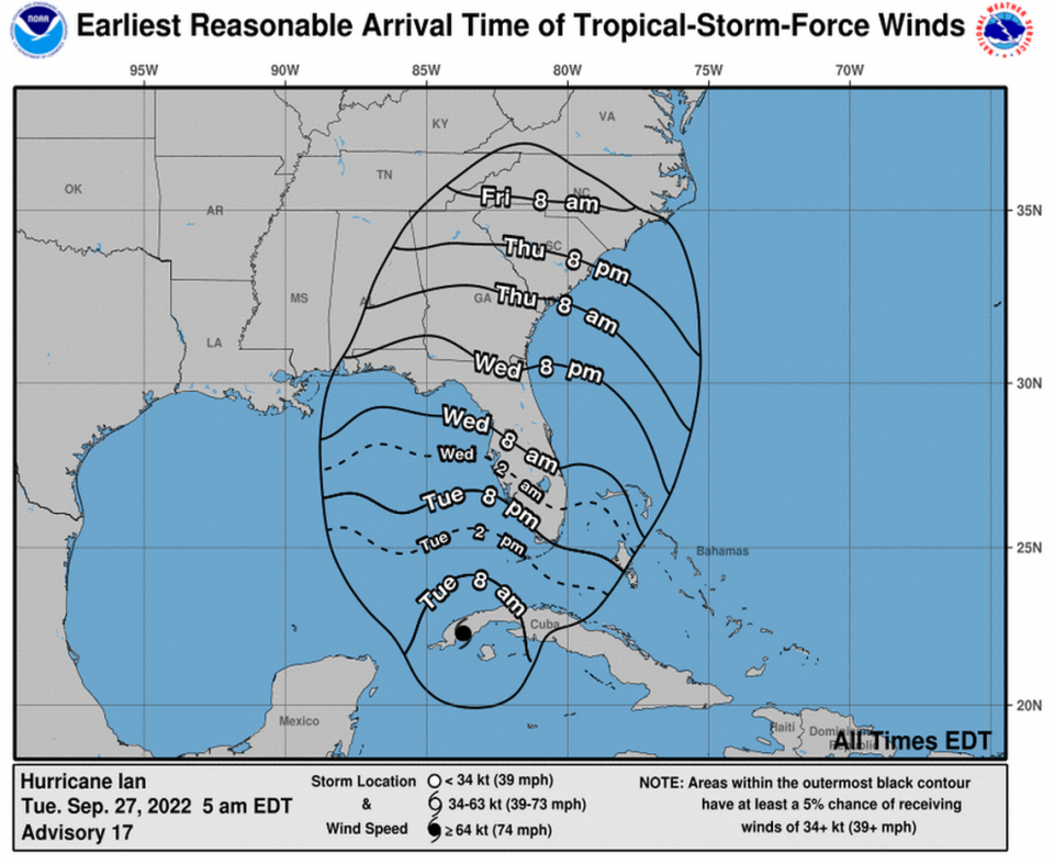
For all areas within the hurricane warning zone, including Manatee and Sarasota counties and Tampa Bay, tropical storm-force winds could possibly arrive overnight; hurricane conditions are expected by Wednesday morning.
— 11 p.m.
Storm surge predictions change
Hurricane Ian remains on track to impact the west coast of Florida as a major hurricane on Wednesday, with landfall currently predicted north of Port Charlotte.
As Hurricane Ian’s track and potential landfall point have shifted southward, forecasters have adjusted storm surge predictions for the west coast of Florida.
Tampa Bay, Anna Maria Island and Manatee County, previously expected to see the highest levels of surge, are now estimated to see maximum surge of 4-6 feet. Even at these lower levels, Ian still threatens local coastal areas with severe and life-threatening surge, the National Weather Service warns.
Meanwhile, maximum surge estimates from the middle of Longboat Key south to Bonita Beach, including Sarasota and Charlotte Harbor, have increased to 8 to 12 feet. Further south, maximum surge estimates for Bonita Beach to Chokoloskee are 6 to 9 feet.
Forecasters have continuously warned that Ian has an unusually high level of uncertainty in its track, and additional shifts could bring more changes to the storm surge forecast.
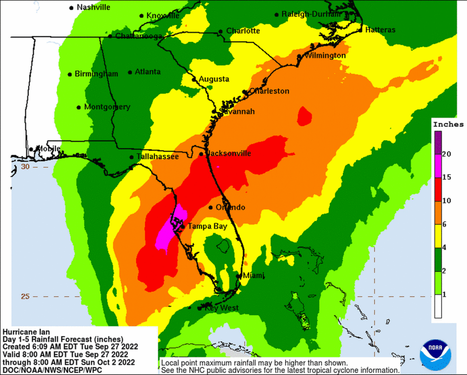
Heavy rains could also spark flash flooding and river flooding throughout Manatee County. Major flooding is forecast for the Manatee River, including Myakka Head at SR 64 and Rye Bridge, starting Wednesday morning until further notice, the National Weather Service said Tuesday night.
— 8 p.m.
Forecast update
Hurricane Ian is restrengthening as it continues on a path towards Southwest Florida. Its track has again shifted slightly southward, according to the National Hurricane Center, causing hurricane and storm surge warnings to be expanded.
A hurricane warning now includes Chokoloskee to Anclote River, including Tampa Bay; a storm surge warning is in effect from the Suwannee River southward to Flamingo, including Tampa Bay, Bradenton and Sarasota.
Landfall is now projected for north of the Port Charlotte area on Wednesday afternoon. But forecasters stress that the track could continue to change, and everyone in the storm’s vicinity should be prepared for impacts.
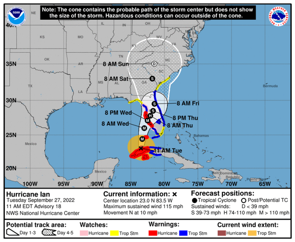
The storm was still a Category 3 hurricane at 5 p.m. with sustained winds of 120 miles per hour. It is about 230 miles south of Sarasota and 50 miles south-southwest of the Dry Tortugas. It is expected to continue gaining steam over the Gulf, and it could potentially make landfall as a Category 4 hurricane, forecasters warned.
— 5 p.m.
Ian intensifying in Gulf waters
Hurricane Ian has begun to re-intensify as the Category 3 storm moves north at 10 miles per hour and has maximum sustained winds of 120 miles per hour, according to the National Hurricane Center.
As of the 2 p.m. update, Hurricane Ian is about 265 miles south of Sarasota and 85 miles south-southwest of the Dry Tortugas.
Radar is showing a lot of lightning around the eye of Hurricane Ian, which “is not a good sign,” Bay News 9 Chief Meteorologist Mike Clay said.
With the current track bring the eye of the storm onshore in Venice, the forecast shows Manatee County could see an unprecedented storm surge of 5 to 10 feet above ground level. Near the eye wall, storm surge could reach 10 to 15 feet.
“Venice is not that far from us. The storm can wobble again,” Manatee County Deputy Director Steve Litschauer said during a news briefing.
— 2 p.m.
Manatee County closes sandbag locations
Just before 2 p.m., Manatee County announced that they had closed all sandbags locations.
“Due to unprecedented demand and delivering over 200,000 plus sandbags, our supplies have been exhausted at all locations,” they announced on Twitter.
FPL preparing response to Ian
Florida Power and Light has thousands of trucks and crews staged at the Sarasota Fairgrounds, 3000 Ringling Blvd, Sarasota in preparation for Hurricane Ian’s aftermath.
Widespread power outages are expected as the center of the Category 3 storm is now forecast to come ashore near the Sarasota or Bradenton area.
“Severe weather, including heavy rain, flooding and high winds, is expected to cause widespread outages throughout Florida’s western and northern peninsula over the next few days,” a statement from FPL said. “They will be deployed into the field as needed for restoration, safely and quickly as possible, and in some cases even in between bands of bad weather.”
— 1 p.m.
Forecast update
Ian has passed over Cuba and is expected to remain more intact through landfall than previously forecast, meaning it would turn northeast quicker and not move as slowly, the National Hurricane Center said in its 11 a.m. update.
“However, it should be emphasized that this track remains very uncertain, with a typical spread in the steering features leading to big speed and track differences down the line, not to mention the oblique angle of approach to Florida,” the NHC said.
Landfall was adjusted further south near Venice and moved up by 6-12 hours to overnight Wednesday. But there are no major changes to Bradenton and Manatee County’s forecast as it is a large and powerful storm that is expected to be nearly Category 4 strength at landfall.
Ian is now a Category 3 and faces conditions favorable for strengthening over the Gulf.
“While the (wind) shear should increase by tomorrow, it isn’t expected to be enough to significantly weaken the hurricane before landfall,” the NHC said.
— 11 a.m.
Eastbound traffic curfew
Beginning at 4 p.m., there will be no westbound access to Anna Maria Island from Cortez Road and Manatee Avenue.
Two new shelters open
Two more emergency shelters at Buffalo Creek Middle School and Haile Middle School — making a total of 17 shelters in Manatee County now open ahead of Hurricane Ian.
All hurricane shelters open:
Nolan Middle School (Special Needs)
Braden River High School (Pet Friendly)
Manatee High School (Pet Friendly)
Mills Elementary School (Pet Friendly)
Bayshore Elementary School
Freedom Elementary School
Gullett Elementary School
Harvey Elementary School
Lee Middle School
Myakka City Elementary School
Miller Elementary School
McNeal Elementary School
Rogers Garden Elementary School
Williams Elementary School
Willis Elementary School
Buffalo Creek Middle School
Carlos E. Haile Middle School
Bradenton homeless shelter being evacuated
With mandatory evacuation orders in place for Zones A and B, The Salvation Army is evacuating its homeless shelter, 1204 14th St. W., near downtown Bradenton.
“Due to typical flooding in this area, it was determined that the safest course of action for clients and staff is to evacuate the premises,” spokeswoman Kelly French said in a news release.
People are being taken to the shelters at Rogers Garden Elementary School or Manatee High School unless they have found somewhere else safe to stay.
Once Hurricane Ian passes and the building is deemed safe, people will be allowed back in the shelter.
— 10 a.m.
Ian expected to reemerge over the Gulf
Hurricane Ian is expected to reemerge over the Gulf of Mexico water Tuesday morning as the current track has the storm making landfall as a Category 3 just north of Palmetto and Bradenton.
As of the 8 a.m. update, Hurricane Ian is currently a Category 3 hurricane, with maximum sustained winds of 125 miles per hour.
Ian made landfall over western Cuba early Tuesday, where it is battering the coast with high winds and life-threatening storm surge. The forecast has it intensifying to a Category 4 storm as it moves into the more favorable gulf waters. but later weakening back to a Category 3 hurricane as it approaches the Tampa Bay area.
The hurricane is moving north at 12 miles per hour, but is expected to slow down as it makes way north along Florida’s west coast.
Hurricane-force winds currently extend out 35 miles from the center and tropical-storm-force winds extend outward up to 115 miles.
The shift in the storm’s path overnight resulted in watches and warnings being extended Tuesday morning.
— 8 a.m.

A Hurricane warning now extends from Bonita Beach in Lee County to Anclote River in Pinellas County, including Tampa Bay. A tropical storm warning was issued from the Anclote River to the Suwannee River in the Big Bend area.
Hurricane Warning for Anna Maria Island, coastal Manatee County
WIND
Equivalent Cat 3 Hurricane force wind
Peak Wind Forecast: 100-120 mph with gusts to 145 mph
Window for Tropical Storm force winds: early Wednesday morning until early Friday morning
Window for Hurricane force winds: Wednesday morning until Thursday afternoon
Remaining efforts to protect life and property should be urgently completed. Prepare for catastrophic wind damage.
Move to safe shelter before the wind becomes hazardous.
POTENTIAL IMPACTS: Devastating to Catastrophic
Structural damage to sturdy buildings, some with complete roof and wall failures. Complete destruction of mobile homes. Damage greatly accentuated by large airborne projectiles. Locations may be uninhabitable for weeks or months.
Numerous large trees snapped or uprooted along with fences and roadway signs blown over.
Many roads impassable from large debris, and more within urban or heavily wooded places. Many bridges, causeways, and access routes impassable.
Widespread power and communications outages.

STORM SURGE
Life-threatening storm surge possible
Peak Storm Surge Inundation: The potential for 7-10 feet above ground somewhere within surge prone areas
Window of concern: Begins early Wednesday morning
Plan for extreme life-threatening storm surge flooding greater than 9 feet above ground.
Evacuation efforts should soon be brought to completion before driving conditions become unsafe.
Leave immediately if evacuation orders are given for your area to avoid being cut off from emergency services or needlessly risk lives.
POTENTIAL IMPACTS: Devastating to Catastrophic
3 FT surge above high tide begins to flood homes along the Manatee River.
3 FT surge above high tide can begin to overtop Anna Maria Island.
4 FT surge above high tide begins to flood homes near Interstate 75 and the Manatee River.
6 FT surge above high tide floods areas south of Port Manatee to U.S. 41.

FLOODING RAIN
Flood Watch is in effect
Peak Rainfall Amounts: Additional 10-15 inches, with locally higher amounts
Emergency plans should include the potential for extreme flooding from heavy rain. Evacuations and rescues are likely.
Urgently consider protective actions from extreme and widespread rainfall flooding.
Heed any flood watches and warnings. Failure to take action will likely result in serious injury or loss of life.
POTENTIAL IMPACTS: Devastating to Catastrophic
Extreme rainfall flooding may prompt numerous evacuations and rescues.
Rivers and tributaries may overwhelmingly overflow their banks in many places with deep moving water. Small streams, creeks, canals, and ditches may become raging rivers. Flood control systems and barriers may become stressed.
Flood waters can enter numerous structures within multiple communities, some structures becoming uninhabitable or washed away. Numerous places where flood waters may cover escape routes. Streets and parking lots become rivers of raging water with underpasses submerged.
Driving conditions become very dangerous. Numerous road and bridge closures with some weakened or washed out.
TORNADO
Situation is somewhat favorable for tornadoes
If your shelter is particularly vulnerable to tornadoes, prepare to relocate to safe shelter before hazardous weather arrives.
If a tornado warning is issued, be ready to shelter quickly.
POTENTIAL IMPACTS: Limited
The occurrence of isolated tornadoes can hinder the execution of emergency plans during tropical events.
A few places may experience tornado damage, along with power and communications disruptions.
Locations could realize roofs peeled off buildings, chimneys toppled, mobile homes pushed off foundations or overturned, large tree tops and branches snapped off, shallow-rooted trees knocked over, moving vehicles blown off roads, and boats pulled from moorings.

