Live updates: Bradenton prepares as path of potential Cat. 4 hurricane Ian shifts east
Find the latest Monday updates for Hurricane Ian here.
Tropical Storm Ian remains on a path toward Florida, but forecasters at the National Hurricane Center say it’s still too early to tell which direction the storm will go.
Here’s what weather officials say it’s important to know Sunday:
▪ Cat. 4: Ian is so far forecast to be an extremely dangerous Category 4 storm with maximum winds of 130 mph over the water. Conditions could weaken it before landfall, but it will still be very destructive for the areas in the cone and well outside of it.
▪ Large storm: Ian is also forecast to have a large wind field. That means even if it stays out over the Gulf, damaging wind and rain could still affect the entire west side of Florida and inland.
▪ Uncertain path: The two major forecasting models still show different paths for Ian, but they are coming closer to agreement. The National Hurricane Center path splits the difference. Everyone along the Florida Gulf Coast should be prepared.
Here are the latest local updates:
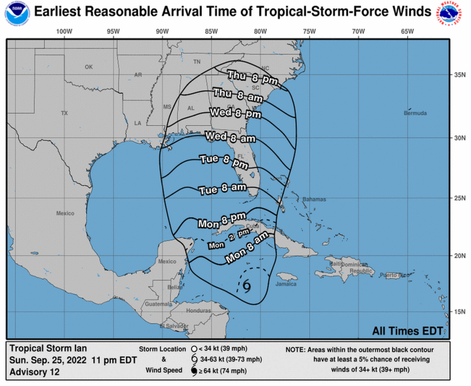
11 p.m. Sunday: Ian strengthening as track shifts further east
Tropical Storm Ian has made the northwest turn that forecasters predicted, and the system is strengthening as it approaches Cuba late Sunday night, an 11 p.m. NHC update said.
Meanwhile, the storm’s track for later this week has shifted slightly more to the east with a potential landfall on the west coast of Florida on Thursday.
But forecasters stress that it is still too soon to predict which route the storm will take in several days, and Ian’s forecast has a higher level of uncertainty than most tropical storms. Southwest Florida and the Tampa Bay area remain in the cone of uncertainty.
“Regardless of Ian’s exact track and intensity, there is a risk of dangerous storm surge, hurricane-force winds, and heavy rainfall along the west coast of Florida and the Florida Panhandle by the middle of this week, and residents in Florida should ensure they have their hurricane plan in place,” the NHC advisory said.
The west coast of Florida could begin to feel tropical storm-force winds by Tuesday, the latest NHC models show.

9:30 p.m. Sunday: Prep now, top emergency official says; USF cancels classes
It’s not too late to get prepared for a potential hurricane Ian, Florida’s top emergency official advised on Sunday.
“Right now, they need to prepare,” Florida Division of Emergency Management Kevin Guthrie told Mike Boylan of Mike’s Weather Page in a video interview Sunday. “It’s not just about the winds and the storm surge. You need to be aware of the tornadoes. You need to be aware of the flash flooding. It’s going to impact everybody.”
Guthrie encouraged residents to make an emergency plan, double check supplies and confirm their evacuation zone.
“Listen to your local emergency manager. If they call for an evacuation, do that.”
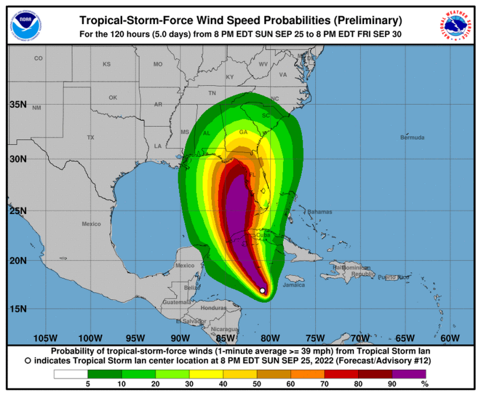
Guthrie also warned of a potential storm surge of 8-16 feet in various parts of west Florida based on recent models.
Also of note, University of South Florida Sarasota-Manatee has canceled classes Monday through Thursday.
Meanwhile, State College of Florida Manatee-Sarasota will remain open Monday. The college will issue an announcement about closures for the rest of the week at 6 p.m. Monday.
6 p.m. Sunday: Manatee, Sarasota schools will be open Monday
All School District of Manatee County schools will be open normal hours on Monday. Parents should stay tuned for updates about potential closures later this week.
“The School District will continue its close collaboration and cooperation with local Emergency Management officials on decisions regarding the rest of the week,” spokesman Michael Barber said in a news release Sunday evening.
Sarasota County Schools will also be open Monday.
“As the track of storm approaches our region there is a possibility that all public school will close on Tuesday, September 27 for shelter openings,” a 4 p.m. update from Sarasota County Schools said.
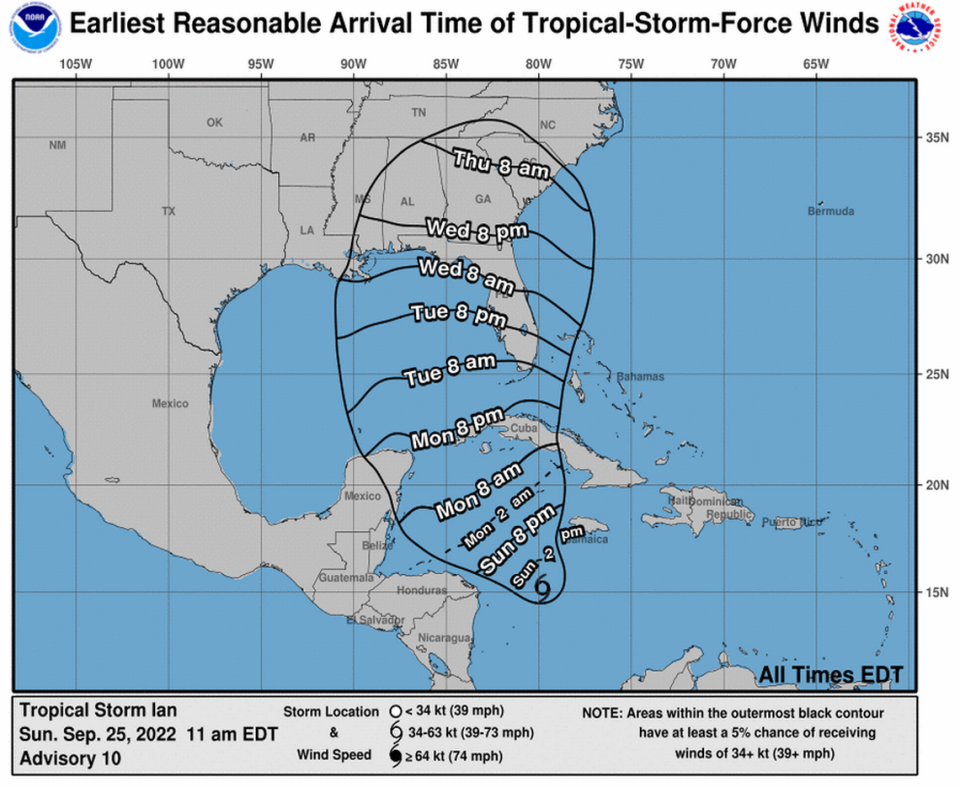
5 p.m. Sunday: Ian’s track shifts east; watch issued for Keys
A 5 p.m. update from the NHC shows Tropical Storm Ian’s track shifting slightly east toward the Gulf Coast of Florida and Tampa Bay area.
The forecasting model that had been predicting landfall in the Panhandle has moved east in the past few cycles, the Hurricane Center said.
But weather experts are asking residents not to focus on the exact path, as hurricane impacts could be felt across much of Florida.
“You can’t be too fixated on this cone and it moving around a little bit. ... Ian is going to be a large and powerful and powerful hurricane in the eastern Gulf of Mexico and spread its impacts over a large portion of the Florida peninsula,” Jamie Rhome, NHC acting director, said in a livestream update Sunday.
The storm is still predicted to get stronger overnight, then strengthening is expected to accelerate. Forecasters predict Ian will become a hurricane Monday and a major hurricane on Tuesday after it passes over Cuba.
“A generally northwestward motion is expected tonight, followed by a north-northwestward motion on Monday and early Tuesday as it moves across the northwestern Caribbean Sea and near or over western Cuba,” the NHC said.
“From there, the track guidance still diverges at days 3-5 as Ian is forecast to move northward across the eastern Gulf of Mexico.”
A tropical storm watch is now in effect for the lower Florida Keys, which means that tropical storm conditions are possible within 48 hours. Hurricane forecasters predict 1-3 feet of storm surge there.
The next update is at 8 p.m.


2 p.m. Sunday: Ian to strengthen, turn northwest later this evening
The latest 2 p.m. Tropical Storm Ian update from the NHC predicts the storm will continue strengthening later tonight before becoming a hurricane by early Monday.
Meteorologists also say Ian will become a major hurricane by early Tuesday before it reaches western Cuba.
The storm is expected to turn toward the northwest later this evening.
Light crowds on Coquina Beach as residents prepare for potential impacts of soon-to-be Hurricane Ian. #tropicalstormian #manateeready pic.twitter.com/WdwJxKWONG
— Jessica De Leon (@JDeleon1012) September 25, 2022
11 a.m. Sunday: Bradenton declares a state of emergency
The city of Bradenton has declared a state of emergency in response to the threat of Tropical Storm Ian, which is expected to strengthen into a hurricane before making landfall along Florida’s west coast later this week.
The Bradenton City Council held a brief meeting Sunday morning where they voted unanimously to approve the emergency resolution. By approving a local state of emergency, city officials become eligible for state and federal emergency resources.
Bradenton’s action follows a similar move taken by the Manatee Board of County Commissioners in an emergency meeting Saturday afternoon.
City Administrator Rob Perry said city officials have begun reviewing emergency operations and preparing for the impact of the storm. The latest 11 a.m. forecast says Ian’s Florida landfall remains unclear.
“Right now, the cone is all the way from Ft. Myers to the Alabama-Florida border and that’s about 250 miles of uncertainty, so we won’t know, but we do need to be prepared,” Perry said.

“We want to be prepared for anything at all,” added Mayor Gene Brown.
Long lines for sandbags
In West Bradenton, the Bradenton Police Department warned that the distribution of sandbags is causing delays between Cortez Road and 21st Avenue West along 59th Street West and 51st Street West, near the entrances to GT Bray Park.
Some folks in line for sandbags at G.T. Bray say they’ve been in line for three hours. @bradentonherald @RCCallihan pic.twitter.com/wutGIpE1Ik
— Tiffany Tompkins (@tompkinscondie) September 25, 2022
GT Bray is one of several sandbag distribution locations. Police urged residents to avoid the area unless they are picking up sandbags.
TRAFFIC ALERT
The city is issuing sandbags in preparations for the incoming storm and it's creating traffic blocks between Cortez Rd W and 21st Ave W along 59th St W and 51st St W by the entrances to GT Bray Park. Please avoid the area unless you're picking up sandbags.— Bradenton Police (@BradentonPD) September 25, 2022
While Ian’s exact path has yet to be determined, public safety officials are warning residents to take the proper precautions. Even if the Bradenton area is not within the direct path of the storm, most of the state is likely to be affected by hurricane-force winds, heavy rain and possible storm surge flooding.
— National Hurricane Center (@NHC_Atlantic) September 25, 2022
“We do anticipate that Ian, especially later today and tonight, will commence the intensification process and become a hurricane,” Jamie Rhome, the acting director of the NHC, said in a livestream update Sunday morning.
8 a.m. Sunday: Tropical Storm Ian could make landfall Friday
Storm trackers say Ian continues moving west-northwest toward Cuba at about 12 mph, with maximum sustained wind speeds near 50 mph. According to the NHC, the storm will pass southwest of Jamaica before making a slight turn to the north.
In the next 48 hours, Ian is expected to undergo rapid strengthening. It could become a major hurricane before it reaches Cuba and continues strengthening in the Gulf of Mexico on its way to Florida, meteorologists said.
The latest forecast track has also pushed back Ian’s expected arrival in Florida. Earlier forecasts predicted the storm might make landfall as a hurricane in Southwest Florida by Wednesday, but the latest model shows Ian might not make landfall until Friday.
However, residents are still expected to brace for the impact of a significant storm. South Florida is still likely to see tropical storm-force winds, heavy rain and storm surge flooding as a result of the Ian.
LIVE TODAY!
We're still tracking #Ian. WATCH hurricane expert @GregPostel share what we know now.
Key takeaway: remain vigilant! pic.twitter.com/QMYvZrmNTv— The Weather Channel (@weatherchannel) September 25, 2022
5 a.m. Sunday: Ian is expected to become a hurricane
In a 5 a.m. forecast advisory on Sunday, NHC experts said Tropical Storm Ian is expected to become a hurricane at some point today, but because the eye of the storm has not fully formed, its path is unclear. However, the cone of uncertainty still includes Manatee, Sarasota and the Tampa Bay Area.
“Ian is expected to remain a major hurricane when it moves generally northward across the eastern Gulf of Mexico during the middle of the week, but uncertainty in the long-term track and intensity forecast is higher than usual,” the NHC wrote.
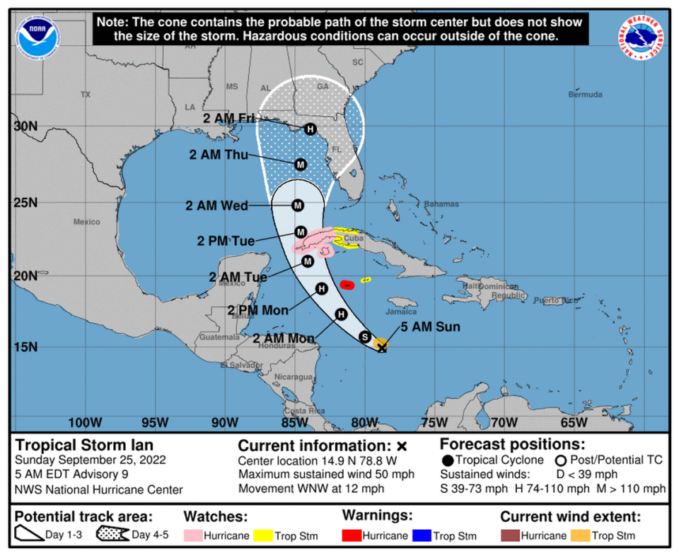
The latest hurricane modeling forecasts show a 200-mile spread of where Ian could make landfall in Florida. As of Sunday morning, another National Oceanic and Atmospheric Administration hurricane surveillance mission is underway, which is expected to help nail down the track of the storm.
Meteorologists say Ian is moving at about 12 mph toward Cuba with maximum sustained wind speeds of 50 mph. While approaching the island, the storm is expected to rapidly intensify and continue toward Florida’s west coast as a major Category 4 hurricane.
In Manatee County, local public safety officials have urged residents to continue monitoring Ian as they put together a hurricane plan. Sandbags are available at several locations around town, as well.
Here are the 5 am EDT Sunday Key Messages for Tropical Storm #Ian. Follow the latest at https://t.co/tW4KeGdBFb pic.twitter.com/PrHODJ0sMi
— National Hurricane Center (@NHC_Atlantic) September 25, 2022

