NJ weather update: Snow in northwest, ice in west, and gusts and flooding at Shore
MOUNT HOLLY — Snow, ice, coastal flooding and high winds will make travel hazardous across much of New Jersey from Sunday night into Monday, according to the National Weather Service.
Forecasters predict winds of 25 to 35 mph with gusts up to 50 mph along coastal Ocean County, eastern and western Monmouth and southeastern Burlington counties.
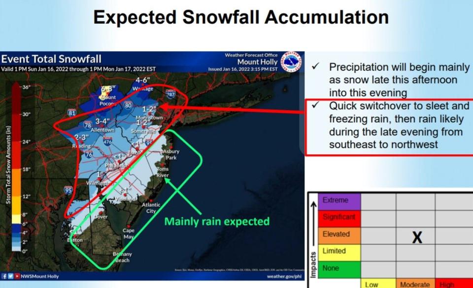
In northern New Jersey, residents could see as much as six inches of snow.
On Sunday evening, the weather service expanded its Winter Weather Advisory into Philadelphia's eastern suburbs in New Jersey and placed New Jersey's northern Atlantic coastline under a Coastal Flood Warning due to expected moderate flooding in low-lying areas of Monmouth and Middlesex counties.

"Gusty winds could blow around unsecured objects," the forecast stated. "Tree limbs could be blown down and a few power outages may result. Use extra caution when driving, especially if operating a high profile vehicle. Secure outdoor objects."
Precipitation would begin as snow, and then quickly change to sleet and freezing rain before warming to rain across much of central and southern New Jersey, according to the weather service.
"Minor tree and line damage will be possible for coastal locations Sunday night as wind gusts of 40 to 50 mph are expected," according to the summary.
Snow, wind and rain coming: Gov. Murphy warns residents to stay off the roads
Northern New Jersey
North-central New Jersey should brace to two to four inches of snow and a glaze of ice while strong and damaging wind gusts move across the region into Monday morning.
Flooding is likely in eastern counties with low-lying areas, whereas northwestern New Jersey will be primarily impacted by ice and snow on Sunday night. Snow amounts could increase in the northwestern part of the state.
Ice amounts as thick as a quarter-inch are possible in the northwest areas of the state, while lesser amounts are more likely in northeast New Jersey. Travel will be hazardous.
High winds could bring down trees limbs and powerlines and lead to power outages, according to the weather service.
While about an inch of snow is expected to have fallen in Paramus by Monday, about five inches are possible in West Milford, according to forecasters.
Central New Jersey
Freezing rain and sleet are likely west of the Interstate 95 corridor. Up to a tenth-of-an-inch of ice is possible on cold roadways and sidewalks.
Wind gusts of up to 40 mph could lead to downed tree limbs and powerlines and subsequent power outages.
About one to two inches of snow is possible in Somerville, Somerset County, with lesser amounts to the south.
Jersey Shore
No snow or ice is expected along the Shore, but the region should prepare for high winds with gusts up to 50 mph. High winds could lead to power outages across the region.
Middlesex and northern Monmouth counties are under a Coastal Flood Warning through Monday. Moderate flood levels are expected in low-lying areas.
In some Jersey Shore towns, officials asked residents to take precautions.
In Berkeley, Mayor Carmen Amato reminded residents not to park on roads to allow for salting, sanding and possible plowing, and offered parking at the township's recreation building on Route 9 or Central Regional Middle School for residents who wanted to move their cars out of low-lying sections of town.
Asbury Park and Neptune Township sent email alerts warning of flooding "on the most vulnerable roads in coastal and bayside communities, and along inland tidal waterways."
South Jersey
The outer Philadelphia suburbs could see icing of roads and cold surfaces and a dusting of snow, making travel conditions hazardous. Areas south and east are more likely to see heavy rain instead.
Minor flooding is possible along the southern Atlantic coast, with spotty minor flooding expected along the Delaware Bay.
Tree and power line damage is possible along the coast and Delaware Bay, where wind gusts will be between 40 and 50 mph through Monday, according to the weather service.
Alex N. Gecan covers local news and unsolved mysteries for the Asbury Park Press. You can reach him at 732-547-1365 or agecan@gannettnj.com, or follow him on Twitter @GeeksterTweets.
This article originally appeared on Asbury Park Press: NJ weather Sunday: Snow ahead for some, wind and flooding elsewhere

