Hurricane Hilary May Have Peaked As Cat. 4 With 145 mph Winds, Forecast To Hit L.A. Late Sunday; Tropical Storm Watch Issued For Much Of Southern CA
UPDATED, Friday at 2:30 p.m. with latest windspeed, graphics: In a rare occurrence, the remnants of Hurricane Hilary is forecast to hit Southern California and possibly Los Angeles this weekend with tropical storm-force winds (39-73 mph) and very heavy rain.
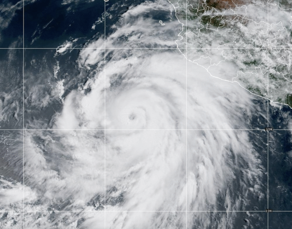
What began as Tropical Storm Hilary off the coast of Mainland Mexico strengthened into a hurricane early Thursday. Over the next 24 hours, the storm’s maximum sustained windspeed rapidly intensified from 75 to 145 mph by Friday morning, making Hilary a strong Category 4 hurricane. The latest 2 p.m.update from the National Weather Service indicated the maximum sustained winds had dropped to 130 mph. That’s at the bottom end of Cat 4.
More from Deadline
Hurricane Hilary Affecting Los Angeles-Area Events: MLB Games Shifted; Theme Parks Monitoring Storm
Michael Cieply: Warnings Are Up For A Stormy Film Awards Season
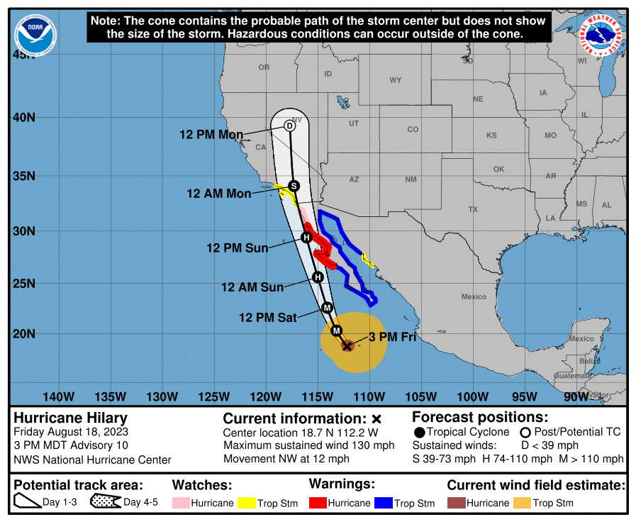
By Sunday, Hilary is expected to become a lesser hurricane and then potentially hit Southern California and Los Angeles with tropical storm-force winds, especially at higher elevations, later in the day. The storm was about 360 miles SSW of Cabo San Lucas by late morning on Friday.
Late Thursday, NWS update also shifted the predicted path of the storm eastward, which could bode well for coastal population centers such as L.A., Orange County and San Diego. But that could mean that drier regions inland face the center of the storm plowing right over them, dropping a full year’s worth of rain in 24-48 hours.
More substantially, for the first time it has the track over Southern California with the letter “S” attached. That means Hilary is expected to still be a tropical storm while roughly over San Diego County. See track map below.
Here is more on the storm’s direction from the National Weather Service:
Hilary is moving toward the west-northwest near 14 mph (22 km/h), and this general motion is expected to continue through tonight. A turn toward the northwest is expected Friday morning, followed by a turn toward the north-northwest and north on Saturday. On the forecast track, the center of Hilary will approach the Baja California peninsula over the weekend.
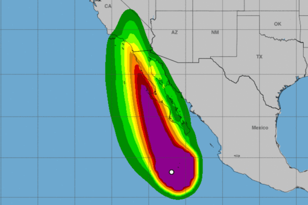
Currently, per the NWS, “Hurricane-force winds extend outward up to 60 miles (95 km) from the center and tropical-storm-force winds extend outward up to 275 miles.”
The updated wind cone (featured as this story’s main image) has an increased chance of tropical storm-strength winds hitting the San Diego area and inland Southern California.
There is also an outside chance of what’s known as a “wet” Santa Ana event, which could bring increased winds, as the circulation pushes north.
Here is the 11 p.m. Thursday National Weather Service forecast chart for the storm’s path:
Only one full-blown tropical storm has hit the coast of California in recorded history: the Long Beach tropical storm that made landfall near San Pedro in 1939, according to the NWS. No tropical cyclone has made landfall in California at hurricane intensity in recorded history.
Earlier today, the National Weather Service issued the first-ever tropical storm watch for Southern California. Per NWS, “A Tropical Storm Watch means that tropical storm conditions are possible within the watch area, generally within 48 hours.”
Two factors tend to keep Southern California safe from such storms: colder sea surface temperatures, which take their fuel away, and upper-level steering winds in the eastern Pacific. This year’s El Niño event means ocean temperatures are much warmer than usual, with the water in Malibu registering 70 degrees today. Normally, 67 or 68 degrees is the warmest coastal ocean temperatures get in the summer in Los Angeles.
Still, hurricane tracks are tricky to predict, especially days out. A recent National Weather Service forecast for Hilary indicates: “There remains a very large spread in the ultimate track so this remains a very low confidence forecast in terms of the track as well as the impacts. However, having said that, virtually all the GEFS ensemble members show moderate to heavy rain amounts, especially south of Point Conception.”
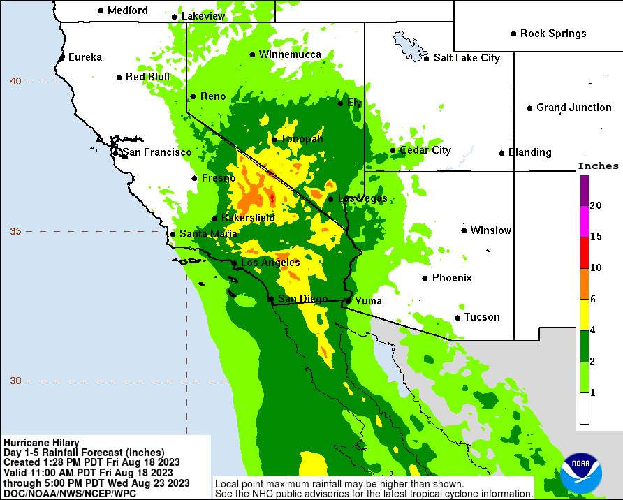
That rainfall currently is pegged at a large accumulation for summer in Southern California with, per the NWS, “several solutions at or above 2.5″ and as high as 2.9” and “100 percent chance of rain” for much of Los Angeles. So the probability of a very anomalous rain event is certainly increasing. The official rain total forecast currently is around 1″-2″ area-wide Sunday through Tuesday but with the potential for much higher (or lower) amounts depending on the actual track. But that’s the low end. “Rainfall amounts of 2 to 4 inches, with isolated amounts in excess of 8 inches, will be possible across portions of southern California and southern Nevada,” per the latest NWS update.
August is generally L.A.’s driest month, with an average annual rainfall of 0″.
Just before 4 p.m. Thursday, the NWS issued a flood watch for Los Angeles and Ventura Counties “from sunday afternoon through Monday evening.” According to the Weather Channel, flood watches have also been issued for much of San Diego, Orange, Imperial and Riverside Counties.
There could also be lightning which, if the storm hits some areas with wind but without rain, could create fire danger.
In terms of waves, the NWS indicates that Hilary “will bring the potential for hazardous marine conditions to all coastal waters starting this Sunday. While any wind/weather impacts from these systems over the local area are highly uncertain, long-period, steep, southerly swells and high surf will be possible during the upcoming weekend and beyond.”
Surf forecaster Surfline is predicting waves from 4-6 feet in Northern L.A. County and 8-10 feet in certain spots of Northern Orange County, like Surfside. Those estimates can drop radically in 24 hours, however, should the storm hew closer to the coast of Baja California — or rise considerably if Hilary were to move out further into Southern California’s swell window. Indeed, just Wednesday, Surfline was predicting 15-20′ surf in Northern L..A., which would have been an ultra-rare occurrence for the region in summer.
Here is Friday’s NWS Los Angeles forecast:
Hurricane Hilary will weaken to a tropical storm as it approaches Southern California this weekend. Flash flooding will be possible across the whole region, with rare and dangerous flooding possible across the mountains and deserts. Strong, tropical-storm-force winds will be possible Sunday through Monday, strongest over the mountains, valleys, and foothills of Los Angeles and Ventura Counties.
Hilary continues to slowly bend to the right, and the initial motion is northwestward or 315/10 kt. A general north-northwest to north motion with a steady increase in forward speed is expected tonight and through the weekend as the system is steered by pronounced steering flow between a strong subtropical ridge over the south-central U.S. and a mid- to upper-level low off the central California coast. The models have trended faster this cycle, and the NHC forecast has followed suit. Based on the latest forecast, the core of Hilary is expected to be very near the central portion of Baja California Saturday night and move inland over southern California by Sunday night. It should be noted that strong winds and heavy rains will occur well ahead of the center.
Fluctuations in the hurricane’s strength are expected through tonight, but Hilary is expected to begin weakening on Saturday as it moves over progressively cooler SSTs and into an environment of increasing shear and drier air. The NHC intensity forecast is lower than the previous one, partially due to the lower initial intensity, and a little higher than the HCCA and IVCN models.
KEY MESSAGES:
Heavy rainfall associated with Hilary will begin well in advance of the center, from the Baja California Peninsula into the Southwestern United States. Preparations for the impacts of flooding from rainfall should be completed as soon as possible, as heavy rain will increase ahead of the center on Saturday. In the Southwestern United States, flash, urban, and arroyo flooding is expected, with the potential for dangerous and locally catastrophic impacts.
Hurricane conditions are expected within portions of the hurricane warning area along the west-central coast of the Baja California Peninsula Saturday night and are possible in the Hurricane Watch area.
Tropical storm conditions are possible by late Sunday in portions of southern California where a Tropical Storm Watch is in effect.
Large swells generated by Hilary will affect portions of the coast of southwestern Mexico, the Baja California peninsula, and south California over the next few days. These swells are likely to cause life-threatening surf and rip current conditions.
Best of Deadline
SAG-AFTRA Interim Agreements: Full List Of Movies And TV Series
2023 Premiere Dates For New & Returning Series On Broadcast, Cable & Streaming
Sign up for Deadline's Newsletter. For the latest news, follow us on Facebook, Twitter, and Instagram.

