Half of Kal-Haven Trail to close. Path in Portage opens. And e-bikes in national parks?
Want to ride the full, 34-mile length of the Kal-Haven Trail from South Haven to Kalamazoo? Better do it before July 10. That’s the day that the 15-mile stretch from South Haven to Bloomingdale will close for resurfacing, not expected to reopen until sometime in early 2024, according to the Michigan Department of Natural Resources, which owns and maintains the trail.
The eastern half of this crushed-limestone path will remain open. Still, it’s never easy to give up a good section of trail, especially for the Kal-Haven, which was the first significant rail-trail in our area.
But what’s concerning folks who live nearest to the trail is that the work will mean removing the beloved Donald F. Nichols Covered Bridge over the Black River, 1.5 miles east of the South Haven trailhead, and replacing it with a standard bridge.
Jan. 25, 2023: Berrien County sets priorities for bike, boat and horse trails
You’ve no doubt snapped photos of the wooden structure if you’ve passed through it. Members of the group Friends of the Kal-Haven Trail are upset, as evident at their Facebook page. In media reports, their president has said they’re hoping and advocating for some form of the covered bridge to come back, though they agree with the DNR that the almost 30-year-old covered bridge, sitting on a 150-year-old railroad trestle, is beyond its serviceable life.
A DNR representative has said that the bridge’s timbers and materials will be saved for a possible future use. This year’s trail work is part of Gov. Gretchen Whitmer’s Building Michigan Together Plan with dollars from the American Rescue Plan.
The Friends group will hold an informal community gathering with light refreshments to bid goodbye to the bridge at noon July 9 at the South Haven trailhead, along Bailey Avenue north of Phoenix Street, where visitors are encouraged to walk or ride out to the bridge.
Gap paved in Marquette Greenway
A nearly one-mile section of paved trail opened in June in Portage, Ind., filling in yet another gap in what will be the 60-mile Marquette Greenway from Chicago to New Buffalo. The city built the trail with a grant from the state’s Next Level Trails program of more than $2.5 million.
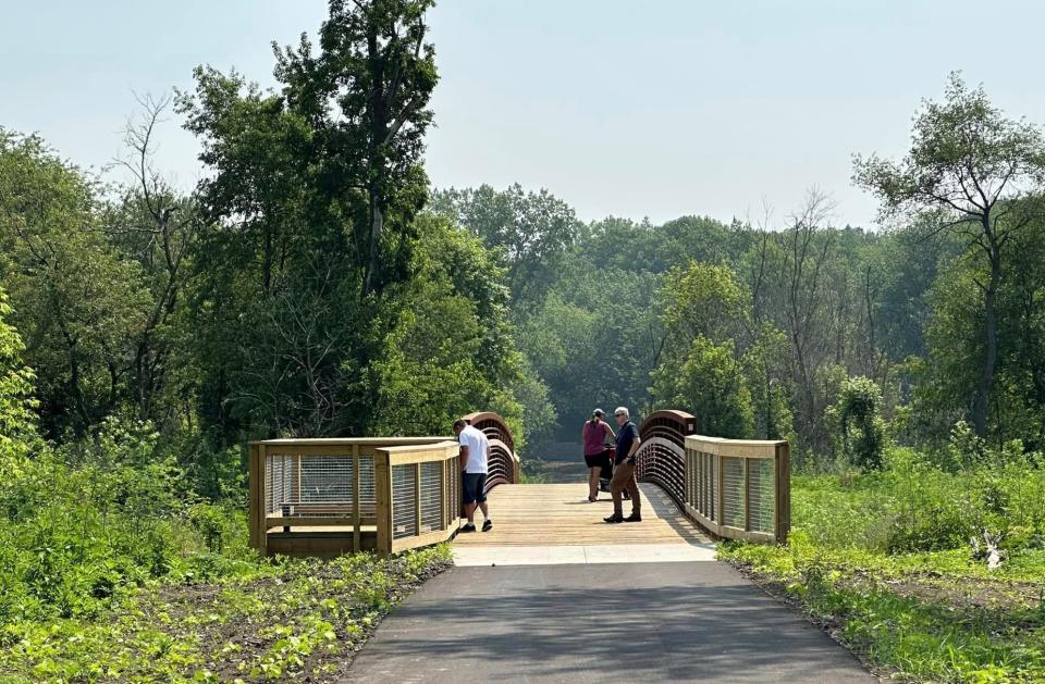
Portage Mayor Sue Lynch acknowledged that this latest piece was “short in distance and costly” but added, “The pedestrian bridge over Salt Creek was a monumental step forward in getting this section of the trail completed.”
Starting at the AmeriPlex business park just northeast of Interstate 94 and Indiana 249, the new trail travels east through Indiana Dunes National Park, crosses Salt Creek and connects with a 1.5-mile section of the Marquette Greenway in Burns Harbor that opened in 2021.
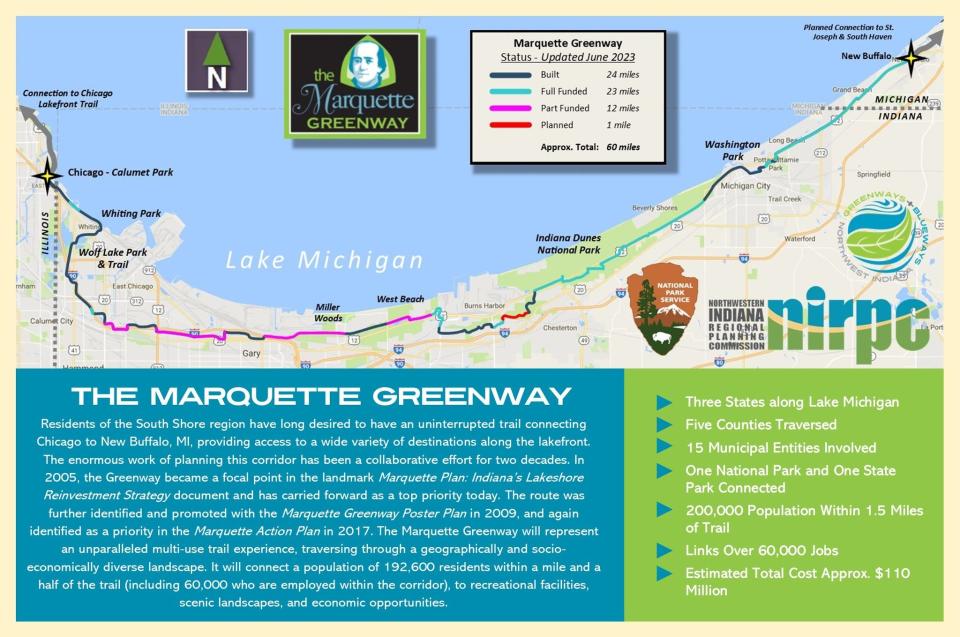
East and west of it, the Greenway has gaps yet to be filled and some completed trails; 24 miles have been built so far. Find a general map of the status attached to this story online.
E-bikes in national parks?
E-bikes have rapidly become a common — even expected — sight on local paved and mountain trails and city streets. But how prevalent should they be in our national parks? That’s what the feds are asking the public to chime in on by July 21. The National Park Service is asking whether or how much e-bikes should be allowed on trails and administrative roads where traditional bikes are allowed in national parks.
June 6, 2022: What you need to know about e-bikes: 3 kinds, who rides them and local regulations
The NPS, of course, is looking at a much broader span of parks than we generally see here in Michiana or at the Indiana Dunes National Park. Think about the 424 units of the National Park Service, each of them unique, ranging from “parks” to “monuments” to “seashores,” depending on the last word in their names. In a 47-page document on this assessment, it spells out the different considerations, including how electric-assisted bikes might affect soils, from grassy meadows to deserts to coastal areas to tropical rain forests.
The NPS is considering two options: 1) do nothing or 2) its preference, which is to allow each park superintendent the discretion to set the policy, based on the site.
E-bikes provide an electric boost (and access) to riders who are limited by disability or illness. They also provide a longer riding range for cyclists, going further than their bodies would physically ride. We may always have folks who are strong enough to pedal on their own but use e-bikes to avoid heart- and brain-healthy exercise. That’s their choice. We just need to be mindful that, if the bike boosts our speed or momentum, we ride respectfully of fellow trail users and wildlife.
There are three e-bike classes: Class 1 goes up to 20 mph. Class 3 goes up to 28 mph. But Class 2, which goes up to 20 mph, also adds a throttle where the motor pushes you along, even without pedaling.
To read more about the NPS assessment and leave your comments by July 21, visit https://parkplanning.nps.gov/e-bikes. Or mail comments to Electric Bicycle Programmatic EA, National Park Service, 1849 C Street NW, MS-2472 Washington, DC 20240.
∎ E-bikes on Indiana trails: As a related side note, the Indiana Natural Resources Commission this year approved a change in state regulations that permits Class 1 e-bikes on mountain bike trails in state parks. The state had already been permitting this, though on a trial basis. Now it’s permanent.
Blotchy bass syndrome
Ever caught a fresh-water bass with black, inky spots on its skin, fins or mouths? That may be blotchy bass syndrome. And the Indiana Department of Natural Resources encourages your help in documenting cases of them on black bass.
The DNR says that researchers used to think that these spots were caused by exposure to the sun or by the stress of fishing, temperature or pollution. But more recently they’ve found a family of viruses in bass whose bodies were in poor condition and had the spots.
To help, you need to download the MyCatch app from Angler’s Atlas and register for the company's “Blotchy Bass Bonanza,” with prizes in this citizen science project, which runs through Feb. 29, 2024. Snap photos of all bass that you catch, blotchy or not, preferably on a measuring board, and upload them to the app. The Bonanza includes smallmouth, largemouth, rock, spotted, suwanee and redeye bass.
The study is part of a larger project by the U.S. Geological Survey. Read more about it in a link in this column online.
Extra jaunts
∎ Women and girls walking: There’s a free weekly walking club for women and girls of all ages at 6 p.m. Wednesdays this summer on the Mishawaka Riverwalk, hosted by the city parks department. Meet at the Ball Band Biergarten at Beutter Park. You can walk the full 3.1 miles or whatever portion you can.
∎ First Friday ride and tacos: Meet up for a group ride at 6 p.m. July 7 on the mountain bike trail at Soldiers Memorial Park in LaPorte, then socialize afterwards at the trailhead and head downtown for Taco Fest, where restaurants will be participating with live music, food and beer.
Find columnist Joseph Dits on Facebook at SBTOutdoorAdventures or 574-235-6158 or jdits@sbtinfo.com.
This article originally appeared on South Bend Tribune: Kal-Haven Trail closes bridge replaced Marquette Greenway Portage grows

