There's a chance of snow on Christmas in Eugene
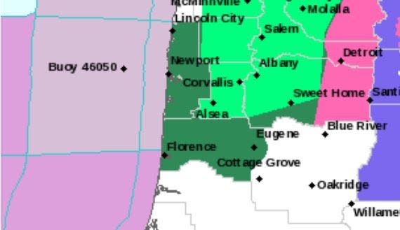
Holiday season travel looks to be wet this week in lower elevations in Lane County and all of western Oregon, with rain expected every day and a chance of snow reaching the Willamette Valley floor on Christmas Day.
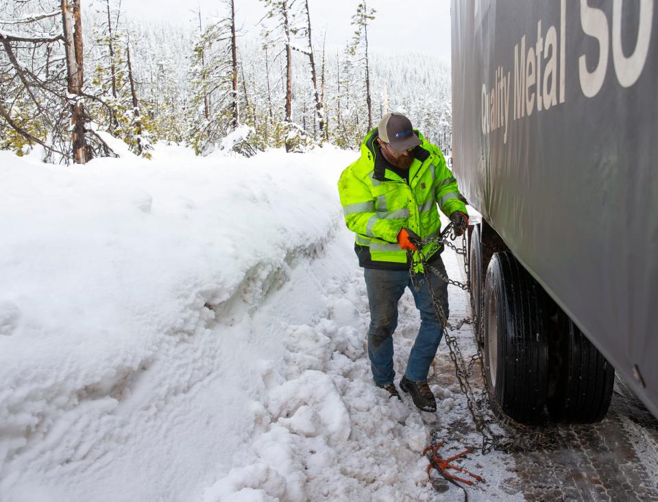
In the upper elevations, expect travel to be slowed and made hazardous by heavy snow starting Tuesday night through Thursday on the Willamette Pass (Highway 58) and Santiam Pass (Highway 20). The National Weather Service issued a winter storm watch for Tuesday night and Wednesday on both passes.
Saturday (Christmas Day) and Sunday forecasts show a mix of snow and rain in Eugene.
The rain will let up a little bit Tuesday, with mostly cloudy skies during the day, with a high of 48. A warm front Tuesday night is expected to usher in between a quarter and a half-inch of rain through Wednesday. Then the temperatures are expected to cool down.
While the Portland area received some snow last weekend, the south Willamette Valley could see its first flakes Saturday, according to NWS Meteorologist Briana Muhlestein, although the forecasts could change by then.
"The likelihood of snow accumulation on Christmas is increasing with recent forecast runs," she said.
Snow levels are expected to drop to 600 feet on Christmas Day, she said. Temperatures also are expected to drop to below freezing Saturday night, Muhlestein said, meaning if snow melts during the day it could refreeze and make driving difficult Sunday.
Snow accumulation is expected to continue further east in the south Cascade Range, and Willamette Pass is forecast to get less than a half-inch of snow Tuesday, and 1 to 3 inches Wednesday.
Travel for the holidays
Drivers traveling north to Washington state or south to California should be ready for rain and snow through the weekend, as weather forecasts are developing. The National Weather Service's forecast said "unsettled weather persists over the Pacific Northwest."
The Cascade Range from Northern California up into Washington are under a winter storm watch. Similarly, the coast and valley areas are expecting rain daily.
The Oregon Department of Transportation advises drivers to take extra time traveling during weather that can quickly change to poor driving conditions.
"The best advice at this point is to know where you're going and the conditions before you go, and take a look at Tripcheck.com," ODOT spokeswoman Angela Beers Seydel said.
Weekend rain causes rises in Siuslaw River, Mapleton
The forecasts continue an already wet weekend that brought flood watches and warnings as well as recording 2.32 inches of rain Sunday at the Eugene Airport, according to the National Weather Service.
A flood warning was issued for the the Siuslaw River and Mapleton on Monday, indicating minor flooding in low-lying areas, along with some structures along the banks in and near Mapleton, the NWS said. The river crested around 10 a.m. Monday, with water rising up to 17.78 feet.
The weather service reminded drivers that they should not attempt to drive around barricades or through flooded areas and instead to turn around. "Most flood deaths occur in vehicles," the NWS stated.
It appears the Mapleton area dodged the 18-foot mark for flooding, which is when minor impacts begin, according to the NWS. Since 10 a.m. Monday the water level has been gradually going down, but NWS meteorologist David Bishop said drivers and residents should remain cautious.
"As you can see it's getting close, but it's looking like it might have turned over," Bishop said. "Definitely be cautious about it and be observant."
The flood watch advised residents to stay alert for the increased danger of a flood warning, and said those living in areas prone to flooding should be prepared to take action should flooding develop.
Aside from flooding, the heavy rain also led to a landslide that closed all lanes of Highway 126 about 10 miles west of Florence at around 4 p.m. Monday.
An estimated 200 yards of mud, trees and rocks were blocking the road following the landslide, ODOT said in a news release, noting the closure is expected to last into the evening.
Over a three-day period, Florence received 6.53 inches of rain measured at the Florence Municipal Airport, going back to Friday afternoon. The city also recorded 3.84 inches of total rain from Saturday afternoon through Sunday, the most in a 24-hour period going back to October 2016.
Muhlestein said tributaries and roads with poor drainage are the most at risk of flooding and one Eugene resident posted a photo Sunday of the Fern Ridge bike path experiencing significant flooding and said Arthur Street nearby was also flooded.
Muhlestein said a cold front that brought rain had been expected to move out of the area sooner, but instead lingered and led to increased flooding.
"It’s kind of been undulating across the Willamette Valley, which has produced a lot of standing water," she said.
Louis Krauss covers breaking news for The Register-Guard. Contact him at lkrauss@registerguard.com, and follow him on Twitter @LouisKraussNews.
This article originally appeared on Register-Guard: Travel watch: Snow expected to make landfall in Lane County this week

