Some coastal evacuations have started in West Florida ahead of Hurricane Ian. What are evacuation zones?
Mandatory evacuations have begun on the west coast of Florida as Hurricane Ian threatens to hit the state as a major hurricane, category 3 or greater, according to forecasts.
The greatest danger in a hurricane is the storm surge, the dome of water pushed ashore by hurricane-force winds that can be more destructive than the winds themselves. And our state is mostly flat and surrounded on three sides by water.
When a storm is heading to your area, be ready to leave, especially if you live in a coastal area. If you live in a zone that has been ordered to evacuate, do it immediately. It helps to know your evacuation zone and where you'll go ahead of time.
Hurricane Ian: 'Floridians up and down Gulf Coast' warned as Hurricane Ian strengthens, could reach Category 4
WeatherTiger: Hurricane Ian: Three scenarios, with divergent levels of destruction to Florida
National Hurricane Center: Latest updates, analyses on Hurricane Ian
What are hurricane or flooding evacuation zones and what do they mean?
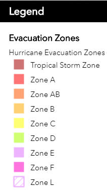
Evacuation zones are areas designated by local and state emergency management as being too dangerous for residents to remain. Hurricane evacuation zones are lettered in increasing levels of vulnerability starting with Tropical Storm Zone and then Zone A to Zone F.
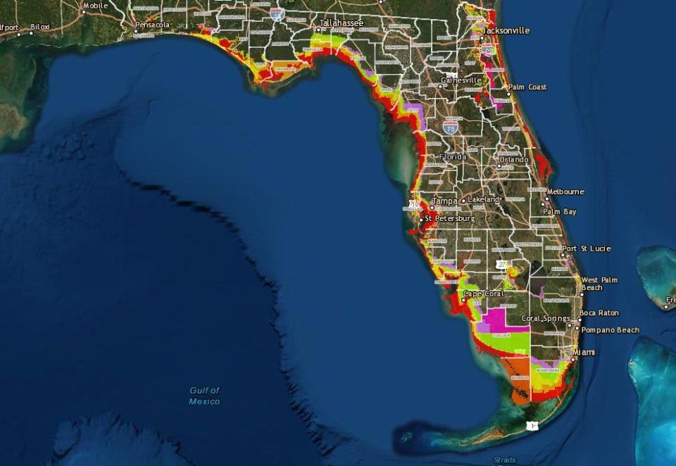
How do I find my evacuation zone?
You can see the zones where evacuations have been ordered, or search for your address, here.
Interior counties do not have designated evacuation zones.
You can see county-by-county maps of storm-surge zone maps based on the most recent studies here, but these are intended for general reference to give you an idea of what to expect in your area.
What are low-lying areas? Do I live in a low-lying area?
Evacuation orders are often issued for "low-lying areas." There isn't a map of Florida's low-lying areas, but there is a map marking "flood zones," which are areas known to flood during storm surges or heavy rain. You can search FEMA's Flood Map by address to see if you're in one of their listed flood zones.
How do I find my Florida hurricane evacuation route?
You can check the map of evacuation zones to find safe routes out. You should also monitor your county's Emergency Management Center for the latest information, evacuation notices and warnings.
The Florida Division of Emergency Management has maps of county evacuation routes here.
C. A. Bridges is a Digital Producer for the USA TODAY Network, working with multiple newsrooms across Florida. Local journalists work hard to keep you informed about the things you care about, and you can support them by subscribing to your local news organization. Read more articles by Chris here and follow him on Twitter at @cabridges
This article originally appeared on Sarasota Herald-Tribune: Hurricane Ian: What are Florida evacuation zones, what do they mean?

