8 feet of snow? Storm train could deal deathblow to wildfire season


A beast of a bomb cyclone will take shape just off the coast of the northwestern United States and western Canada later this week, and AccuWeather forecasters say it will rival, in some aspects, the intensity of strong hurricanes from the Atlantic this season. The powerful storm will bring dangerous and damaging impacts up and down the West Coast, but the precipitation it will deliver to parts of California, Oregon and Washington is greatly needed.
The storm will have some tropical origins.
Satellite imagery indicates that the moisture associated with this storm train will be transported all the way from India and other parts of southeast Asia across the northern Pacific and into the western U.S., according to Senior Meteorologist and Manager of Forecasting Technology Mike Doll. Energy from former Severe Tropical Storm Namtheun, which churned over the western Pacific, will join forces with a non-tropical system sitting over the northern Pacific on Wednesday, according to AccuWeather Meteorologist Randy Adkins.
Rapid strengthening will result. As the storm comes together a few hundred miles off the coasts of Washington and British Columbia, its intensification could easily surpass the criteria for bombogenesis.
Meteorologists define a bomb cyclone as a rapidly strengthening storm with a central pressure that plummets by 0.71 of an inch of mercury (24 millibars) or more within 24 hours. The process is referred to as bombogenesis. As the pressure drops rapidly in the center of the storm, air rushes in to replace the vacuum created in the atmosphere and can produce damaging winds.
The central pressure of the storm is forecast to dip to approximately 28 inches of mercury (948 millibars), putting the bomb cyclone at or even below the intensity level of Hurricane Larry, which was a long-lived and intense cyclone that churned across the Atlantic in early September. At peak strength, Larry was a major Category 3 hurricane with maximum sustained winds of 125 mph and higher gusts. Its central pressure dropped as low as 28.20 inches of mercury (955 millibars).
 |
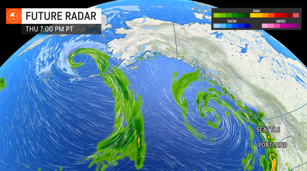
Future radar shows the bomb cyclone off the coast of western Canada on Friday evening. (AccuWeather) |
It will not, however, come close to the strength of Hurricane Ida, which, at its peak, was a strong Category 4 storm with a minimum central pressure of 27.43 inches of mercury (929 millibars).
Damaging winds are possible from the northwestern tip of Vancouver Island, British Columbia, and the Haida Gwaii archipelago in British Columbia as the storm rapidly intensifies at midweek. In this area, wind gusts of 40-60 mph are expected with an AccuWeather Local StormMax™ of 80 mph as the storm's associated cold front charges eastward, Adkins explained.
The monster storm will be packed with plenty of moisture and wind energy, and act as a catalyst for other storms that will target the Pacific coast of the U.S. and Canada. Each storm will have its own level of strengthening but will likely not rise to the same intensity of the offshore bomb cyclone.
As the circulation of the bomb cyclone ramps up, winds and wave action will increase over the coastal Northwest into Thursday and as far away to the north as the Aleutian Islands on Friday, where NOAA's Ocean Prediction Center is forecasting waves as high as 48 feet.
"Strong wind gusts of 40-50 mph can also be expected for coastal sections of Washington and Oregon into Thursday, but with the center of the bomb cyclone forecast to remain offshore, wind damage will be relatively minor and will certainly pale in comparison to the bomb cyclone from Thanksgiving week in 2019," Adkins added.
Conditions are likely to remain stormy in the coastal Northwest into next week and are forecast to expand southward through the coast of Southern California into next week.
 |
As the pattern evolves and more storms spin southeastward across the Pacific, the rounds of rain and mountain snow will ramp up significantly.
Snow will fall at varying elevations over the course of several days as each storm blows through. Up to a couple of feet of snow could pile up across the highest elevations of the Cascades and Olympics through the middle of next week. Farther south, an AccuWeather StormMax™ of 8 feet of snow is predicted over the highest ridges and peaks in the central and northern Sierra Nevada.
The heavily traveled Donner Pass along I-80 in California, about 40 miles west of Reno, Nevada, will see a changeover to snow late Sunday night, and heavy snow will continue to fall through Monday night. There is the potential for 1-2 feet of snow and locally higher amounts, which could shut down travel for a time along the major highway.
The snow that accumulates in the mountains may provide bonus runoff into streams this fall or next spring, should snowpack remain in place through the winter. Significant drought caused several of California's critical reservoirs to reach historic lows this year.
Each storm will bring a period of heavy precipitation, but it will be the storm hitting from Sunday to Monday that is most likely to produce a firehose effect, a phenomenon known as an atmospheric river. This stream of intense moisture from the Pacific is likely to take aim primarily at Northern California, though some precipitation will make it into southern Oregon and parts of central California.
 |
Northern and central parts of California could pick up 4-8 inches of rain from Sunday to Tuesday morning alone. The StormMax™ during that timeframe is predicted to be 16 inches. Through the duration of the stormy period, rain totals may approach 8-12 inches in Northern California with a StormMax™ of 20 inches.
 |
AccuWeather Meteorologist Alex DaSilva said the storm has the potential to "be a tremendous shot in the arm due to the long-term drought in the region." As of Oct. 12, 2021, 46% of California was in exceptional drought, the highest level of drought severity, according to data from the U.S. Drought Monitor.
The unfolding stormy pattern will knock temperatures down and may also effectively shut down the wildfire season in much of California, just as other storms earlier this autumn and late this summer have done in the coastal Northwest, DaSilva added.
While all of the storms will have their benefits, one of the coming storms, in particular, could be especially problematic.
By Monday, soaking rain as far south as coastal areas in Southern California will begin falling, including spotty showers across some of the desert areas.
"Storms prior to the 'big one' early next week will prime the landscape and set the stage for quick runoff with the big storm carrying the potential for enough rain to cause widespread flash flooding and mudslides, especially in, but not limited to the burn scar areas in Northern California, Oregon and Washington," AccuWeather Senior Meteorologist Joe Lundberg said.
More than half of all of the rain in the week-long pattern and the majority of the high-country snow in California may fall during that single storm early next week.
People with homes built along the hillsides in recent burn scar locations will need to be extra vigilant with the stormy pattern unfolding into early next week. As the rounds of rain soak the ground, the topsoil can become progressively unstable.
Forecasters also warn motorists never to attempt to drive through flooded roads. The reasons include, but are not limited to, the risk that the water may be deeper than it appears, water may still be rising and road surfaces can wash away beneath floodwaters.
Large waves are likely to sweep southward along the coast of Southern California later this week to next week and are likely to be a boon to surfers, but large breakers and strong rip currents will pose dangers to bathers.
The stormy pattern will bring rain and hazards to some communities along the West Coast, particularly in California, and it could be a bellwether of what's to come this winter.
"The pattern unfolding this week to next week may be one of the biggest series of storms for the rainy season for California, but there is still potential for a couple of bigger storms over the winter," AccuWeather Lead Long-Range Forecaster Paul Pastelok said.
For the latest weather news check back on AccuWeather.com. Watch AccuWeather Network on DIRECTV, DIRECTVstream, Frontier, Spectrum, fuboTV, Philo, and Verizon Fios. AccuWeatherNOW is streaming on Roku and XUMO.
