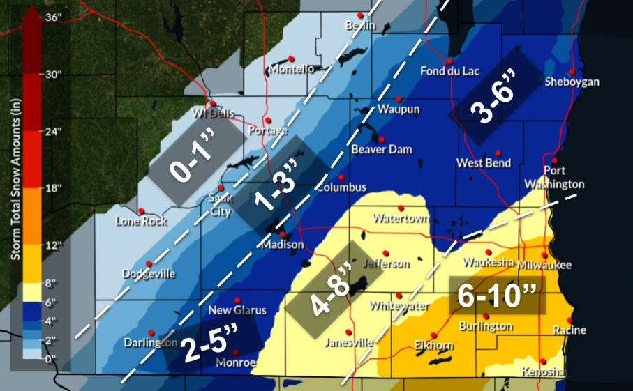
Winter storm warning issued for the Milwaukee area, expect 6 to 10 inches of 'heavier snow'
Wisconsin will see some late March snow as a system moving northeast from Texas looks like it is tracking into the Badger state.
As the storm nears, the National Weather Service has issued a winter storm warning for southeast Wisconsin counties from 4 a.m. to 1 p.m. on Saturday, and a winter weather advisory for the surrounding counties.
The National Weather Service predicts the Milwaukee area could be getting anywhere from 6 to 10 inches of snow. Here’s what you need to know.
6 to 10 inches are possible for Milwaukee, Waukesha, Racine, Kenosha
Snow is expected to move in Friday night and linger into Saturday afternoon, but the peak period for most of the state will be from 6 a.m. to 1 p.m. on Saturday when low temperatures will provide the best chance for accumulation.
According to the weather service, areas closer to the lake are also expected to have a higher chance of seeing more significant snowfall numbers as Waukesha, Milwaukee, Walworth, Kenosha, Racine counties are under a winter storm warning. Jefferson and Rock counties were added to the warning late Friday night.
Here is the evening update for our latest thinking regarding the impending winter storm. We have expanded the Winter Storm Warning further west (Rock & Jefferson) as a secondary band appears more likely bring increased snowfall. #wiwx #swiwx pic.twitter.com/TEaYXW1T7l
— NWS Milwaukee (@NWSMilwaukee) March 25, 2023
"We're expecting heavier snow to set up across southeast Wisconsin, that might waver a little bit north or south," said meteorologist JJ Wood with the weather service.
The surrounding counties like Dodge and Washington will see less snow, but still a significant amount of heavy snow, Wood said. Those areas are under a winter weather advisory.
In Fox Valley, accumulating snow looks likely, but not as significant, as 2 to 4 inches are predicted. Again, areas closer to the lake will have a higher chance of seeing more significant snow totals as Oshkosh, Appleton, Green Bay and Manitowoc all have at least a 50% chance of seeing 4 inches of snow.
Temperatures expected to be near freezing, will result in heavier snow
Wood expects temperatures across the state to be in the mid- to low-30s, nearing freezing. The mild temperatures will result in more accumulation.
"That's one of the reasons why we're expecting heavy, wet variety. ... This will be very heavy snow to shovel," Wood said.
The grassier areas will see more accumulation than roadways due to the mild temperatures but Wood said still expect "slippery" and "slushy" roads on Saturday morning.
Wisconsin weather radar
Our subscribers make this reporting possible. Please consider supporting local journalism by subscribing to the Journal Sentinel at jsonline.com/deal.
DOWNLOAD THE APP: Get the latest news, sports and more
This article originally appeared on Milwaukee Journal Sentinel: 6 to 10 inches of snow expected in parts of southeast Wisconsin

